
From the editors:
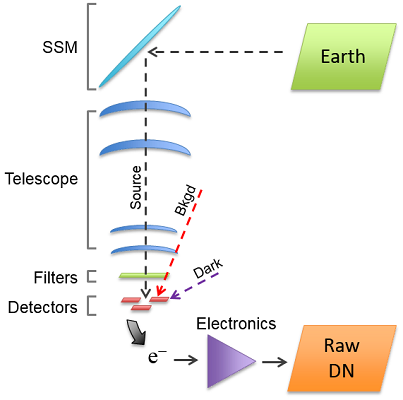
Landsat 8 (formerly LDCM) was launched on February 11, 2013. There are two new sensors on Landsat 8: the Operational Land Imager (OLI) and the Thermal Infrared Sensor (TIRS). Unlike historically used whisk broom scanners (as on the ETM+ sensor on Landsat 7), these new sensors are examples of push broom technology. In addition to having new instruments that have their individual characteristics and calibrations, the change in sensor technology produces significant differences in data characteristics and quality. This Special Issue aims to provide the user community with a good understanding of the radiometric and geometric properties of the Landsat 8 instruments and their data. This understanding will enable the community to effectively use the data in conjunction with data from other earlier Landsat sensors.
View 18 open access papers on topics such as:
OLI Design
OLI Spectral Characterization
OLI Absolute Radiometric Calibration and Traceability
OLI Radiometric Characterization
OLI Radiometric Cross calibration
OLI Spatial Performance Characterization
OLI Geometric Characterization and Calibration
TIRS Design
TIRS Spectral Characterization
TIRS Absolute Radiometric Calibration and Traceability
TIRS Radiometric Characterization
TIRS Radiometric Cross calibration
TIRS Spatial Performance Characterization
TIRS Geometric Characterization and Calibration
Landsat 8 integrated data product geometric performance
Landsat 8 Image Assessment System
Further Reading:
+ Visit Landsat 8 Remote Sensing Special Issue
+ Landsat Ghostbusters—How the Landsat Calibration Team Caught a Ghost
+ Keeping Cal

Be Part of What’s Next: Emerging Applications of Landsat at AGU24
Anyone making innovative use of Landsat data to meet societal needs today and during coming decades is encouraged to submit and abstract for the upcoming “Emerging Science Applications of Landsat” session at AGU24.


