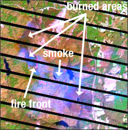
Source: USGS

- Approximately 6,000 acres of burned area is visible from space. On February 11, the U.S. Geological Survey’s satellite, Landsat 7, captured an image of the fires south of Richmond and Petersburg, Virginia. The blue area near the bottom of the image represents smoke from the flames. The maroon regions are recently burned areas and the orange color on the edge of the maroon areas indicates active fires at the time of the image.
Landsat 7 flies at an altitude of approximately 445 miles and has a 16 day cycle for complete global coverage of the land mass of the planet. Fire fighters, disaster management teams and state and local officials frequently use the satellite images to monitor location, extent and condition of burned areas.


