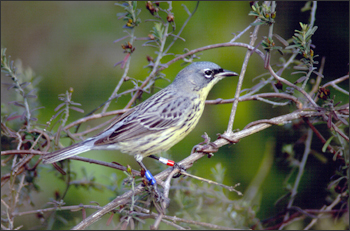
The U.S. Fish and Wildlife Service listed Kirtland’s warblers as endangered in 1967 after a startling decline of over 50 percent in less than ten years. The little birds prefer to nest on the ground amidst large areas of relatively young jack pine trees, and these trees need fire to reproduce. When fires were dramatically suppressed in the 1960s across northern Michigan, Wisconsin and southern Ontario, the warbler’s habitat became scarce.
After an intensive recovery program that focused both on combating invasive cowbirds and managing controlled forest burns, and thus creating warbler-friendly jack pine habitat, the Kirtland’s warbler made an impressive comeback. By 1995 their numbers had tripled.
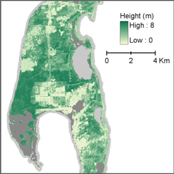
But those extensive efforts only occurred at the Kirtland’s summer home, so a team of researchers reviewed the conditions of many a warbler’s winter home – the Bahamian island of Eleuthera. They did this by painstakingly putting together Landsat data to create cloud-free images of the isle’s forest cover.
Tropical islands typically have cloud cover, so the team compiled many Landsat images with scenes where the clouds were in different places into one image of clear forest, said Eileen Helmer. She’s a member of the Landsat Science Team for the U. S. Geological Survey (USGS) and works for the U.S. Department of Agriculture Forest Service International Institute of Tropical Forestry.
The researchers did this not just once, but ten times, obtaining a record that spans a 30-year time period. According to Helmer, this allows them to tell how long it had been since the forest was last disturbed by fire, crops or grazing.
What the scientists discovered was that, like in their summer homes, Kirtland’s warblers are found in young forests. On Eleuthera, these forests only occur after a disturbance of some sort – like fire, clearing for agriculture, or grazing. And grazing turns out to be a disturbance the warbler can live with just fine. Old forest whose underbrush has been munched on by goats provides the most suitable habitat for warblers, said Helmer.

The results, published in this month’s issue of Biotropica, suggest that goat grazing stunts the forest regrowth, so that the tree height doesn’t exceed the height beyond which important fruit-bearing forage tree species are shaded out by taller woody species. Helmer said that understanding how and where the warbler’s winter habitat occurs will help conservation efforts in the Bahamas.
Helmer said that a unique feature of warbler’s winter habitat is that the age of this forest correlates very strongly with its height. By tracking the age of the forest after a disturbance, she and her team determined forest height at different times. Helmer said they used image time-series data from Landsat and the Advance Land Imager (ALI) sensor aboard the Earth-Observing 1 (EO-1) satellite to essentially ‘stack’ many images over time. This project is the first time that forest height profiles have been successfully mapped by satellite imagery at a medium resolution that shows a broad area but still resolves human impacts on the land. As in the warbler case, understanding how a forest is put together in three dimensions is important for ecological studies. Helmer adds that this tool may be applied elsewhere around the world due to Landsat’s global coverage and policy of free access to data. Helmer will discuss mapping forest height at the American Geophysical Union conference in San Francisco on Friday, Dec. 9.
Source: Aries Keck, NASA Goddard and Rachel Headley, USGS EROS
Further Information:
+ Satellite Data Shows that Kirtland’s Warblers Prefer Forests After Fire, NASA Earth

How Early Astronaut Photographs Inspired the Landsat Program
In the 1960s, NASA was pioneering a new era of human spaceflight—and astronaut photography—that would change Earth observation forever.


