Search
Close this search box.

Time is of the Essence When Monitoring Dryland Floods

Time is of the Essence When Monitoring Dryland Floods

By Laura E.P. Rocchio, Landsat Communication and Public Engagement Team

The Murray-Darling Basin study area
The Murray-Darling Basin is located in southeast Australia. This image shows satellite coverage of Landsat and Sentinel-2 over the study area. The basin’s major rivers and water bodies are shown in blue and elevation derived from the Shuttle Radar Topography Mission range from green (low) to red (high). Image credit: Tulbure et al., 2022

A bird’s-eye perspective is essential for monitoring floods—deadly and costly natural hazards. Today, satellites are our most reliable tool for detecting and tracking floods and other changes in surface water extent over large expanses of land through time.

A paper published in the ISPRS Journal of Photogrammetry and Remote Sensing earlier this year, demonstrated that more frequent satellite observations, such as those of the Harmonized Landsat Sentinel-2 (HLS) dataset, are needed to fully capture flood dynamics in regions experiencing short-lived, ephemeral flooding.

The authoring team, led by Mirela Tulbure from North Carolina State University’s Center for Geospatial Analytics, used Australia’s Murray-Darling Basin to assess the impact of satellite image collection frequency on automated flood-detection. The Murray-Darling Basin—home to more than 2.3 million people—is a water-stressed, drought-prone river basin in southeast Australia with many competing demands for its limited water supply.

Ibis and egret colony in the Yantabulla Swamp, Australia
An egret and ibis colony in the Yantabulla Swamp, which is found within the Murray-Darling Basin in southeast Australia. Climate change–induced drought threatens both the wetland and its wildlife inhabitants. Timely satellite-based inundation information can help water managers distribute limited water resources. This photo was taken as part of an aerial waterbird survey conducted by the University of New South Wales Sydney. Photo credit: Richard Kingsford, Center for Ecosystem Science, UNSW Sydney

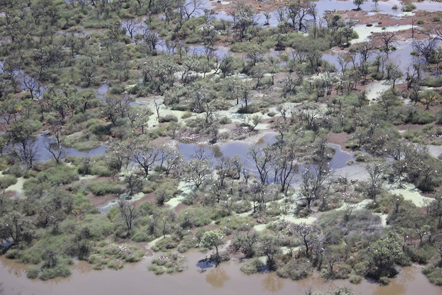
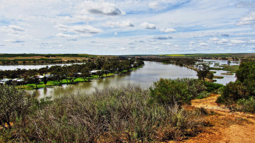
The dryland basin produces a third of the country’s food supply and is home thousands of biologically diverse wetlands, 200 recognized as nationally significant, and 16 internationally protected under the United Nation’s Ramsar Convention. River flow volume in the Murray-Darling basin varies significantly from year-to-year, long droughts are often broken by periods of intense, flood-producing rainfalls. The floods are ephemeral in nature, coming and going quickly, and easily missed without frequent satellite observations.

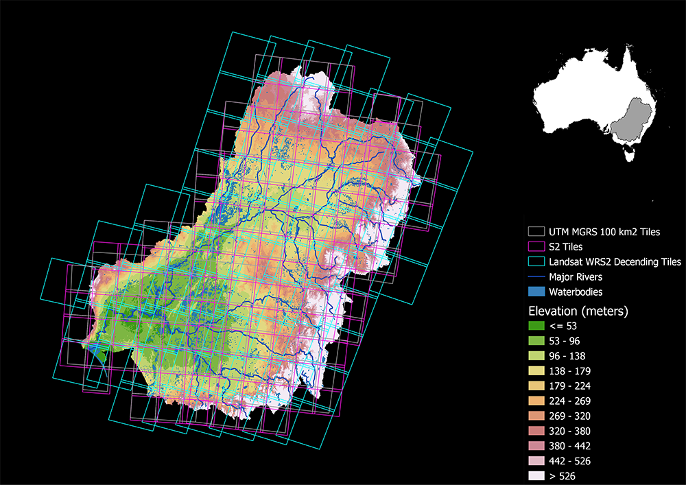
Landsat 8 by itself observes a given swath of Earth every 16 days (together with Landsat 9 that same swath is observed every 8 days*); the European Space Agency’s Copernicus Sentinel-2 system with its two satellites observes a given swath every 5 days; and together Landsat 8 and the two Sentinel-2 satellites observe a given location every 3- to 4-days.

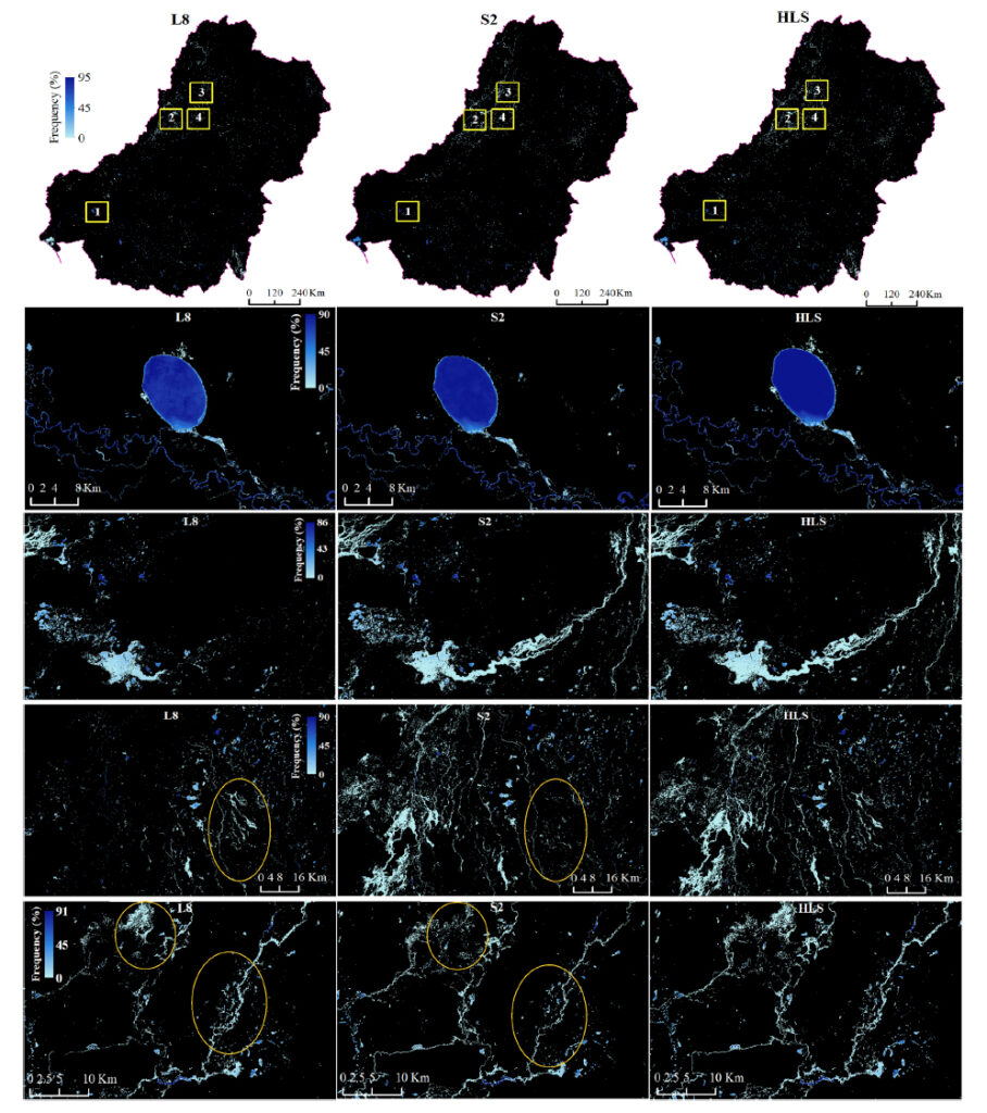
The study design quantified surface water and flooding in the basin during 2019, the driest and hottest year on record, using the HLS dataset in three different ways: (1) just Landsat 8 data, (2) just Sentinel-2 data, and (3) the combined HLS data product. An automated detection technique (relying heavily on the shortwave infrared spectral information captured by the satellites, and several water extraction and vegetation indices) was used to discriminate water from non-water areas.

As expected, the combined HLS data product with its 3- to 4-day repeat observations captured more flooding events than either Landsat or Sentinel-2 alone. In dryland locations like the Murray-Darling basin where floods appear and dissipate rapidly, cloud-cover and satellite overpass frequency combine to determine if the flood event will be captured—the HLS dataset was shown to be a firm step forward for better quantification of such ephemeral flooding in such locations.

Surface water and flooding frequency in the Murray-Darling Basin
A comparison of surface water and flooding events in Australia's Murray-Darling Basin caught by Landsat 8, Sentinel-2, and the HLS combination. Image credit: Tulbure et al., 2022

*The HLS dataset now also includes data from Landsat 9, launched on Sept. 27, 2021.

Of note: The authors conclude that more frequent satellite observations (also referred to as better satellite temporal resolution) is imperative to fully capture flood behavior, making ready-to-use harmonized satellite products like HLS very valuable to flood mapping work.

They also emphasize the need for visible, near infrared, and shortwave infrared spectral information (they state that thermal infrared information helped too by enabling better cloud mask creation).

The authors also advocate for smaller than 30-meter spatial resolution to cut down on “mixed pixels” (satellite pixels that are only partially covered by water and therefore spectrally ambiguous when trying to classify as water covered or not).

In many ways, this paper’s findings echo the Landsat Data User surveys conducted by NASA and USGS during the architecture formulation phase of Landsat Next. A higher temporal resolution was the highest user-requested improvement for the next generation Landsat satellites, followed by higher spatial and spectral resolution requests.

Photo of Murray River near Younghusband, Australia
The Murray River as it winds through wetlands and the town of Younghusband in South Australia. Photo credit: Clarko1959, Pixabay

Banner Image Caption: An egret and ibis colony in the Yantabulla Swamp, which is found within the Murray-Darling Basin in southeast Australia. Climate change–induced drought threatens both the wetland and its wildlife inhabitants. Timely satellite-based inundation information can help water managers distribute limited water resources. This photo was taken as part of an aerial waterbird survey conducted by the University of New South Wales Sydney. Photo credit: Richard Kingsford, Center for Ecosystem Science, UNSW Sydney

On Key

Recent Posts

On Key

Related Posts