Search
Close this search box.

USGS Opens Door to Landsat 9 Data

USGS Opens Door to Landsat 9 Data

Source: U.S. Geological Survey

Landsat 9 image of Anchorage, AK
False color image of the Anchorage, Alaska area, as observed by Landsat 9 on November 20, 2021. The image was built using infrared, red, and blue bands of the electromagnetic spectrum. Image credit: Landsat 9

At this time, USGS Landsat 9 Collection 2 Level-1 and Level-2 data will be made available for download from EarthExplorerMachine to Machine (M2M), and LandsatLook. Initially, USGS will provide only full-bundle downloads. USGS will provide single band downloads and browse images, and Landsat 9 Collection 2 U.S. Analysis Ready Data shortly thereafter. Commercial cloud data distribution will take 3-5 days to reach full capacity.

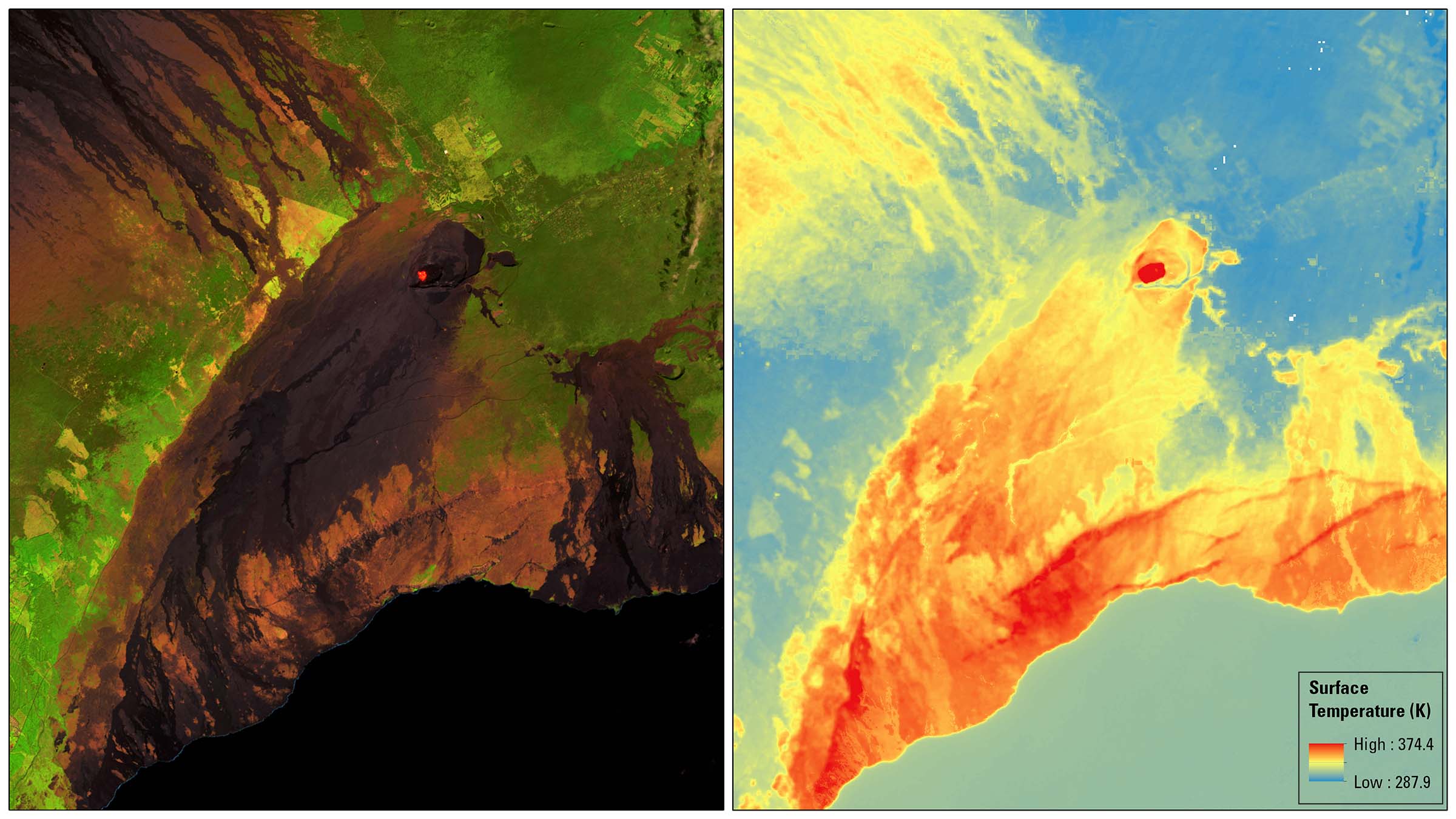
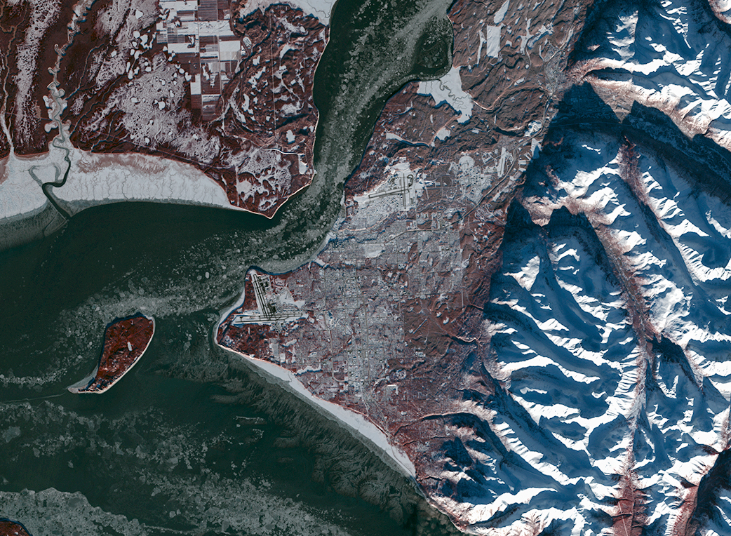
The recently deployed Landsat 9 satellite passed its post-launch assessment review and is now operational. This milestone marks the beginning of the satellite’s mission to extend Landsat’s unparalleled, 50-year record of imaging Earth’s land surfaces, surface waters, and coastal regions from space. Landsat 9 launched September 27, 2021, from Vandenberg Space Force Base in California. The satellite carries two science instruments, the Operational Land Imager 2 (OLI-2) and the Thermal Infrared Sensor 2 (TIRS-2). The OLI–2 captures observations of the Earth’s surface in visible, near-infrared, and shortwave-infrared bands, and TIRS-2 measures thermal infrared radiation, or heat, emitted from the Earth’s surface.

Landsat 9 image and surface temperature map of Kilauea in Hawaii
These images of Hawaii’s Kilauea Volcano, captured on January 25, 2022, show two of the USGS science products built from imagery collected by the Landsat 9 satellite. The left image shows Landsat surface reflectance, a product that removes atmospheric interference to best mirror on-the-ground conditions, as recorded here in the short-wave infrared, near infrared and red bands of the electromagnetic spectrum. On the right is the same image seen through the lens of the Landsat surface temperature product, which records temperature in Kelvin. Image credit: Landsat 9

Landsat 9 improvements include higher radiometric resolution for OLI-2 (14-bit quantization increased from 12-bits for Landsat 8), enabling sensors to detect more subtle differences, especially over darker areas such as water or dense forests. With this higher radiometric resolution, Landsat 9 can differentiate 16,384 shades of a given wavelength. In comparison, Landsat 8 provides 12-bit data and 4,096 shades, and Landsat 7 detects only 256 shades with its 8-bit resolution. In addition to the OLI-2 improvement, TIRS-2 has significantly reduced stray light compared to the Landsat 8 TIRS, which enables improved atmospheric correction and more accurate surface temperature measurements. 

All commissioning and calibration activities show Landsat 9 performing just as well, if not better, than Landsat 8. In addition to routine calibration methods (i.e., on-board calibration sources, lunar observations, pseudo invariant calibration sites (PICS), and direct field in situ measurements), an underfly of Landsat 9 with Landsat 8 in mid-November 2021 provided cross-calibration between the two satellites’ onboard instruments, ensuring data consistency across the Landsat Collection 2 archive. 

Working in tandem with Landsat 8, Landsat 9 will provide major improvements to the nation’s land imaging, sustainable resource management, and climate science capabilities. Landsat’s imagery provides a landscape-level view of the land surface, surface waters (inland lakes and rivers) and coastal zones, and the changes that occur from both natural processes and human-induced activity.  

“Landsat 9 is distinctive among Earth observation missions because it carries the honor to extend the 50-year Landsat observational record into the next 50 years,” said Chris Crawford, USGS Landsat 9 Project Scientist. Partnered in orbit with Landsat 8, Landsat 9 will ensure continued eight-day global land and near-shore revisit.” 

Since October 31, 2021, Landsat 9 has collected over 57,000 images of the planet and will collect approximately 750 images of Earth each day. These images will be processed, archived, and distributed from the USGS Earth Resources Observation and Science (EROS) Center in Sioux Falls, South Dakota. Since 2008, the USGS Landsat Archive has provided more than 100 million images to data users around the world, free of charge. 

Landsat 9 is a joint mission between the USGS and NASA and is the latest in the Landsat series of remote sensing satellites. The Landsat Program has been providing global coverage of landscape change since 1972. Landsat’s unique long-term data record provides the basis for a critical understanding of environmental and climate changes occurring in the United States and around the world.  

The data from Landsat 9 is available for anyone to download. With both Landsat 9 and Landsat 8 in orbit, there will be high-quality, medium-resolution images of Earth’s landscapes and coastal regions every eight days. Video credit: NASA’s Goddard Space Flight Center

Banner Image Caption: Natural color image of Eleuthera Island, the Bahamas, as seen by Landsat 9 on January 18, 2022. Between Landsat 8 and Landsat 9, the Landsat program delivers complete coverage of the Earth’s surface every eight days. Image credit: Landsat 9

On Key

Recent Posts

STELLA Photos

STELLA Spring Webinar: April 15, 2024

STELLA users will talk about their experiences using the DIY spectrometer during this webinar. Panelists include Bianca Cilento (RIT), Karen Karker (SUNY), and Peder Nelson (OSU and NASA GLOBE Observer).

Read More »
On Key

Related Posts

STELLA Photos

STELLA Spring Webinar: April 15, 2024

STELLA users will talk about their experiences using the DIY spectrometer during this webinar. Panelists include Bianca Cilento (RIT), Karen Karker (SUNY), and Peder Nelson (OSU and NASA GLOBE Observer).

Read More »