
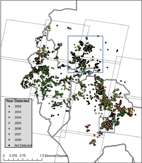
The international human rights community has used satellite imagery to monitor human right violations in troubled regions for years, but they largely rely on visual assessments of high-resolution commercial satellite imagery to verify eyewitness accounts. Marx has shown that spectral analysis of moderate-resolution Landsat data can detect burned villages in arid regions.
Using his analysis method and 650 Landsat images of Darfur, Marx documented the succession of burned villages during the conflict. Marx’s amassed information showed destruction on a near-biweekly basis instead of the traditional annual timeline. By putting together this new temporal information with geographic location, he has found that rebel groups who were not signatories of the ceasefire were most often responsible during ceasefire violations.
This research suggests that extent of human rights violations may be decreased in the future with routine monitoring of moderate-resolution satellite data. Authorities could be more rapidly alerted about burned villages (or other spectrally significant events) and take action to preempt similar violations in the region.
Further Reading:
+ A New Approach to Detecting Mass Human Rights Violations Using Satellite Imagery (pdf)
+ Using LANDSAT Data to Detect, Rather than Confirm, Mass Human Rights Violations, Directions Magazine
+ Satellite can spot razed villages in Darfur, Nature
Reference:

Saudi Arabia’s Desert Agriculture
In this animation of 2024 and January 2025, crop fields in Saudi Arabia cycle through their growing seasons.


