
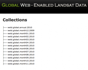
Each of the 13 directories shown on the collection page contain ~5000 to 8000 HDF files nested to MODIS land tile grids. A What You See Is What You Get (WYSIWYG) internet interface to browse and order these data in GeoTiff format will be available later this summer.
This data release is the beginning of a global WELD project suite that will provide monthly and annual Landsat 30m information for any terrestrial non-Antarctic location for six 3-year epochs spaced every 5 years from 1985 to 2010. All data will be NEX reprocessed.
Further Information:
+ About the WELD Project

Be Part of What’s Next: Emerging Applications of Landsat at AGU24
Anyone making innovative use of Landsat data to meet societal needs today and during coming decades is encouraged to submit and abstract for the upcoming “Emerging Science Applications of Landsat” session at AGU24.


