
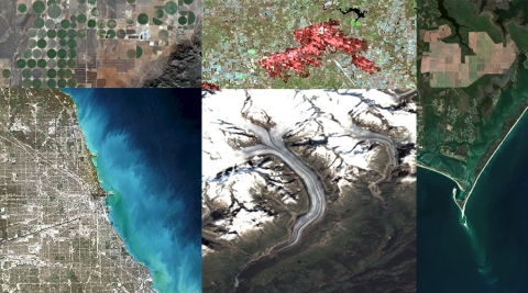
 On Thursday, May 19, 2022, NASA EarthData in collaboration with NASA EOSDIS gave an webinar about the Harmonized Landsat Sentinel-2 (HLS) project. HLS is a NASA initiative to produce seamless, harmonized surface reflectance data from the Operational Land Imager (OLI) and Multi-Spectral Instrument (MSI) aboard Landsat 8–9 and Sentinel-2 Earth-observing satellites, respectively, providing a global observation of the Earth’s surface at a 30-meter spatial resolution every 2–3 days.
These data are useful in a wide variety of applications, including agriculture, natural disasters, urbanization, and more. The webinar provided an introduction to HLS data; showed users how to find resources to work with the data; showcased demonstrations to visualize, search for, and access the data through NASA Worldview and Earthdata Search; and provided data use case examples and a demonstration of HLS data in the Fire Information for Resource Management System (FIRMS) tool to monitor fires and floods.
The webinar was presented by Danielle Golon of the LP DAAC and Brian Freitag from NASA Marshall.

Be Part of What’s Next: Emerging Applications of Landsat at AGU24
Anyone making innovative use of Landsat data to meet societal needs today and during coming decades is encouraged to submit and abstract for the upcoming “Emerging Science Applications of Landsat” session at AGU24.


