Landsat’s Role in Managing Ecosystems and Biodiversity
Our world is made of complex networks of living things and physical elements that constantly interact and affect each other. Such networks are known as “ecosystems.” Healthy and economically important ecosystems such as temperate forests, wetlands, grasslands, coastal zones, coral reefs, and rainforests all play roles in human life. For example, farm and rangeland ecosystems must be healthy to produce the grains and livestock on which we depend as a nation. Marine ecosystems depend on the health of land ecosystems, because coastal areas provide habitat needed to support the productivity and diversity of aquatic organisms. Landsat has brought valuable capabilities to ecosystem studies. Landsat instruments measure reflected light in visible and infrared wavelengths. Because plants reflect little visible light and a lot of infrared light when they are healthy, the measurement of both types of light simultaneously gives scientists a way to assess plant health and density over a landscape. Measurements are detailed enough while still covering a wide area that ecologists can expand their interpretations of local events and processes, such as an insect infestation in a specific forest, to a regional scale. This helps them to gauge the health of larger ecosystems. Because Landsat data are accurately mapped to reference points on the ground and adjusted for topographic relief, they can be integrated with other geographic data sets and models to explore more complex studies of ecosystems and biodiversity across space and time.
![A rural Tuscan landscape](https://landsat.gsfc.nasa.gov/wp-content/uploads/2020/03/Tuscany-rural-336668Pb-1.jpg)
Landsat Gives Epidemiologists Key Insights
How the fields of epidemiology and remote sensing intersect to help the public.
![Nereocystis luetkeana](https://landsat.gsfc.nasa.gov/wp-content/uploads/2020/03/20200305_nu1-1024x481-1.jpg)
Landsat Boosts Understanding of Climate Change’s Impact on Kelp
Landsat imagery shows that bull kelp canopy area can vary dramatically from year to year, and that long-term population trends vary from reef to reef.
![The coastal city of Zhuhai.](https://landsat.gsfc.nasa.gov/wp-content/uploads/2020/02/zhuhai-4651069_960_720-1.jpg)
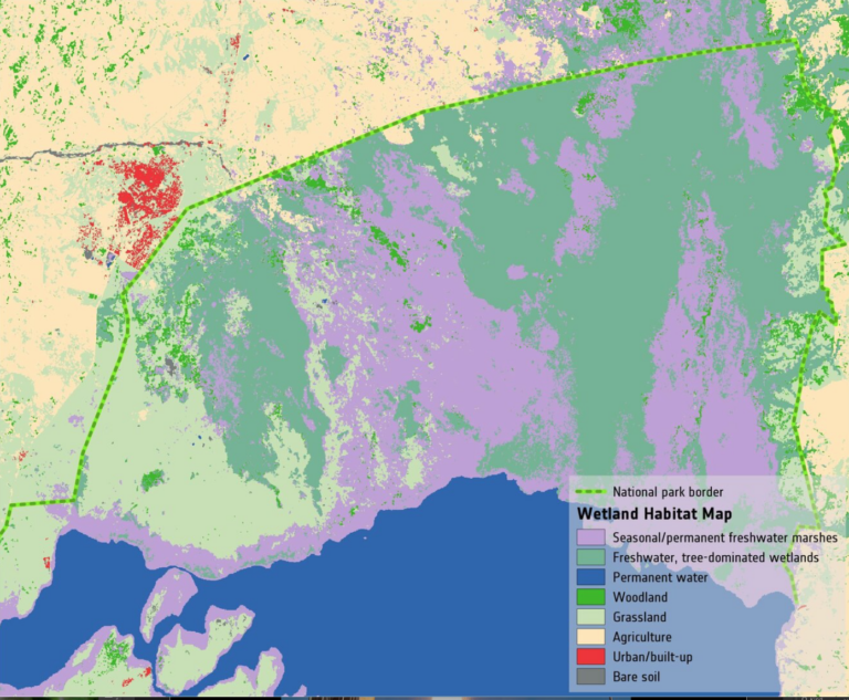
Landsat Provides “Complete Perspective” of Wetland Loss in China
Intertidal wetlands significantly contribute to China’s environmental and ecological diversity, but are facing unprecedented pressures from anthropogenic development, as well as the threat of future sea level rise.
![Children play near the Sesan River](https://landsat.gsfc.nasa.gov/wp-content/uploads/2020/02/sesan-750x500-1-300x200-1.jpg)
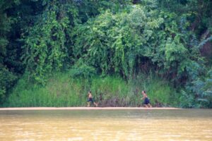
Hydropower Dams Cool Rivers in the Mekong River Basin, Landsat Shows
Researchers used Landsat satellites to track changes in surface water temperature for the Sekong, Sesan and Srepok rivers. Within one year of the opening of a major dam, downstream river temperatures during the dry season dropped by up to 3.6ºF.
![Map of Lake George habitat](https://landsat.gsfc.nasa.gov/wp-content/uploads/2020/02/MapofLakeGeorgeHabitat-768x633-1.png)
Space Key to Wetland Conservation
Wetlands worldwide are vanishing at an alarming rate. New satellite-informed maps produced by ESA’s GlobWetland Africa project show how satellite observations can be used for the effective use and management of wetlands in Africa.
![The photos here show what subnival ecosystems in Nepal’s Sagarmatha National Park](https://landsat.gsfc.nasa.gov/wp-content/uploads/2020/01/Anderson_etal2020-768x417-1.png)
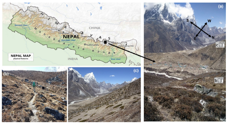
Landsat Reveals Expanding Plant Life in the Everest Region
Plant life is expanding in the area around Mount Everest, and across the Himalayan region, new research shows.