
Root of the Matter: A New Map Shows Decline of Life-Saving Forests
Contributor: Gretchen Cook-Anderson, NASA‘s Earth Science News Team Countless people clung to life in the branches of trees hemming the shorelines during the deadly 2004 tsunami that killed more than 230,000
Landsat-Based Publication Shows Glaciers Retreating in Asia
Source: Jessica Robertson and Jane Ferrigno, USGS Many of Asia’s glaciers are retreating as a result of climate change. This retreat impacts water supplies to millions of people, increases the likelihood
MSS Transition to LPGS Processing
Source: USGS Landsat Mission Website The Landsat project will begin processing MSS data on the Level-1 Product Generation System (LPGS) on September 15, 2010. This is the same system that creates
Hurricane Katrina: A NASA Satellite Video Retrospective
Landsat is featured in a NASA video retrospective on Hurricane Katrina showing the storm as captured by NASA satellites. Further Information: + Hurricane Katrina: A NASA Satellite Video Retrospective + Forests Damaged by Hurricane
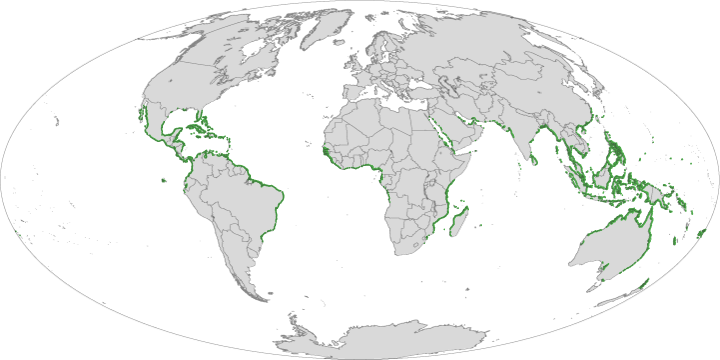
Landsat Enables World’s Most Comprehensive Mangrove Assessment
The most definitive map of Earth’s mangrove forests has been created with Landsat data. A group of scientists, led by Chandra Giri from USGS-EROS, has calculated that approximately 53,190 square
A Landsat Milestone: Three Million Free Scenes Distributed
USGS EROS has distributed over three million scenes for free via the internet since October 1, 2008. Source: + USGS Landsat website
Landsat Time Series Used to Map Tropical Dry Forest Height
A team of researchers led by Landsat Science Team member Eileen Helmer has used Landsat time series data to map forest height on the island of Eleuthera. In the past,
Technical Paper: The Thermal Infrared Sensor on LDCM
A team of scientists presented a technical paper explaining the design of the thermal sensor (TIRS) that will be flown on the Landsat Data Continuity mission at the 2010 IGARSS
Most Accurate Map of Antarctica's Landmass Made From Landsat Data
Antarctica may not be the world’s largest landmass — it’s the fifth-largest continent — but resting on top of that land is the world’s largest ice sheet. That ice holds
Root of the Matter: A New Map Shows Decline of Life-Saving Forests
Contributor: Gretchen Cook-Anderson, NASA‘s Earth Science News Team Countless people clung to life in the branches of trees hemming the shorelines during the deadly 2004 tsunami that killed more than 230,000
Landsat-Based Publication Shows Glaciers Retreating in Asia
Source: Jessica Robertson and Jane Ferrigno, USGS Many of Asia’s glaciers are retreating as a result of climate change. This retreat impacts water supplies to millions of people, increases the likelihood
MSS Transition to LPGS Processing
Source: USGS Landsat Mission Website The Landsat project will begin processing MSS data on the Level-1 Product Generation System (LPGS) on September 15, 2010. This is the same system that creates
Hurricane Katrina: A NASA Satellite Video Retrospective
Landsat is featured in a NASA video retrospective on Hurricane Katrina showing the storm as captured by NASA satellites. Further Information: + Hurricane Katrina: A NASA Satellite Video Retrospective + Forests Damaged by Hurricane
Landsat Enables World’s Most Comprehensive Mangrove Assessment
The most definitive map of Earth’s mangrove forests has been created with Landsat data. A group of scientists, led by Chandra Giri from USGS-EROS, has calculated that approximately 53,190 square
A Landsat Milestone: Three Million Free Scenes Distributed
USGS EROS has distributed over three million scenes for free via the internet since October 1, 2008. Source: + USGS Landsat website
Landsat Time Series Used to Map Tropical Dry Forest Height
A team of researchers led by Landsat Science Team member Eileen Helmer has used Landsat time series data to map forest height on the island of Eleuthera. In the past,
Technical Paper: The Thermal Infrared Sensor on LDCM
A team of scientists presented a technical paper explaining the design of the thermal sensor (TIRS) that will be flown on the Landsat Data Continuity mission at the 2010 IGARSS
Most Accurate Map of Antarctica's Landmass Made From Landsat Data
Antarctica may not be the world’s largest landmass — it’s the fifth-largest continent — but resting on top of that land is the world’s largest ice sheet. That ice holds
