News Archives
![Global Mangrove Map made with Landsat](https://landsat.gsfc.nasa.gov/wp-content/uploads/2022/07/global_tm5_mangroves.png)
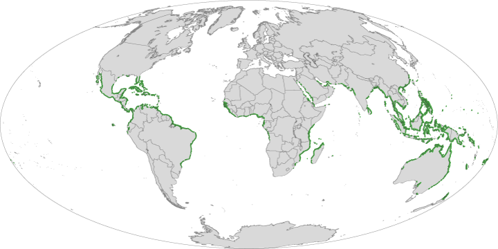
Landsat Enables World’s Most Comprehensive Mangrove Assessment
The most definitive map of Earth’s mangrove forests has been created with Landsat data. A group of scientists, led by Chandra Giri from USGS-EROS, has calculated that approximately 53,190 square
A Landsat Milestone: Three Million Free Scenes Distributed
USGS EROS has distributed over three million scenes for free via the internet since October 1, 2008. Source: + USGS Landsat website
Landsat Time Series Used to Map Tropical Dry Forest Height
A team of researchers led by Landsat Science Team member Eileen Helmer has used Landsat time series data to map forest height on the island of Eleuthera. In the past,
Technical Paper: The Thermal Infrared Sensor on LDCM
A team of scientists presented a technical paper explaining the design of the thermal sensor (TIRS) that will be flown on the Landsat Data Continuity mission at the 2010 IGARSS
Most Accurate Map of Antarctica's Landmass Made From Landsat Data
Antarctica may not be the world’s largest landmass — it’s the fifth-largest continent — but resting on top of that land is the world’s largest ice sheet. That ice holds
Thune Amendment For Continued NASA-USGS Landsat Coordination
U.S. Senator John Thune had an amendment accepted today by the Senate Commerce, Science, and Transportation Committee to the 2010 National Aeronautics and Space Administration (NASA) Reauthorization Bill, which will
Study Using Landsat Finds Amazon Storm Killed Half a Billion Trees
A single, huge, violent storm that swept across the whole Amazon forest in 2005 killed half a billion trees, according to a new study funded by NASA and Tulane University.
ESA To Follow Landsat's Lead on Data Policy for its GMES Data
Space News has reported that the European Space Agency (ESA) is planning to offer data from its Global Monitoring for Environment and Security (GMES) project for no cost. The article sites
News Archives
Landsat at 2009 AGU Fall Meeting
At the annual fall AGU meeting in San Francisco, CA, Landsat was featured in 20 different scientific talks and posters featuring topics as diverse as the carbon cycle, glaciers, phenology,
Landsat 5 Anomaly
Source: USGS On Friday, December 18, 2009, the transmitter on Landsat 5 experienced technical difficulties. There has been no Landsat 5 data acquired since that time. The U.S. Geological Survey Flight
LDCM Proceeds to Final Design and Fabrication Phase
The NASA Agency Management Council confirmed that the Landsat Data Continuity Mission is ready to proceed to the final design and fabrication phase of mission development following a Dec. 16,
Ecosystem, Vegetation Affect Intensity of Urban Heat Island Effect
NASA researchers studying urban landscapes have found that the intensity of the “heat island” created by a city depends on the ecosystem it replaced and on the regional climate. Urban
USGS Technical Announcement: A New Album of Global Earth Imagery
Source: Ron Beck, USGS A new collection of selected Landsat earth images worldwide, Global Land Survey 2005 (GLS2005), is now available for free download to any user around the globe. Under
LDCM Spacecraft Passes Critical Design Review
Source: General Dynamics General Dynamics Advanced Information Systems successfully completed the Critical Design Review (CDR) for the NASA Goddard Space Flight Center’s Landsat Data Continuity Mission (LDCM) spacecraft which is
Landsat Calibration Meeting Held
Source: Brian Markham The Landsat Calibration Working Group held their semi-annual meeting in Tahoe City, Nevada on December 2-3, 2009. USGS/EROS Image Assessment System (IAS), NASA/GSFC Landsat Project Science Office,
Evaluating Mangroves After the 2004 Indian Ocean Tsunami
During the devastating 2004 Indian Ocean tsunami, more than 200,000 people lost their lives. Some coastal communities were shielded from the waves’ destruction by mangrove forests, which motivated efforts to
How Wetlands and Rice Paddies Affect the Spread of Bird Flu
In the mid-1990s, highly pathogenic avian influenza (bird flu) emerged in southern China. Severe outbreaks in the winter of 2005-2006 spread the virus, designated H5N1, across Asia, Europe, and Africa,