
USGS Landsat Archive Hits 8 Million
The USGS Landsat archive has reached eight million scenes.
App Helps Ecologists Map Vulnerable Ecosystems Within Minutes
A mapmaking app that can fast-track large-scale ecosystem analysis from months to minutes.
USGS Landsat Video: The Progress of Landsat Sensor Technology
Landsat sensor technology has come a long way since the days of the Return Beam Vidicon cameras on the first three Landsat satellites.
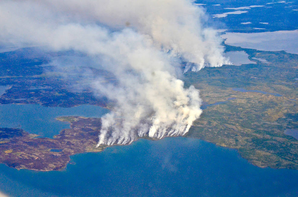
Fires, Floods and Satellite Views: Modeling the Boreal Forest’s Future
The 2014 megafires in Canada’s Northwest Territories burned 7 million acres of forest, making it one of the most severe fire events in Canadian history.
USGS, NASA Officials Cut Ribbon on New Landsat 7 Flight Operations Center
A ribbon-cutting ceremony for the new Landsat 7 Mission Operations Center (MOC) at the Goddard Space Flight Center was held this month.
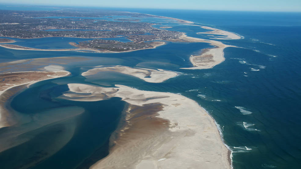
Landsat-based Global Study of World’s Beaches Shows Threat to Protected Areas
Using 30 years of Landsat data, a team of scientists and engineers from the Netherlands determined how Earth’s sandy beaches are changing.
Avalanches Becoming More Frequent and Powerful in Alaska, Landsat Shows
As global temperatures rise, melting permafrost is expected to cause more frequent and hazardous landslides.
Come Play with Us! Exploring America with Landsat for Earth Science Week 2018
A new 2018 Earth Science Week poster offers inspiring Landsat views of the American landscape and has a fun game of exploration on its reverse side.
Supraglacial Lakes Are Not Destabilizing Greenland’s Ice Sheets, Yet
Using Landsat 8 satellite images from 2014 to 2016, researchers have discerned when the lakes on Greenland’s Petermann ice tongue formed, their movement, and changes in surface extent across time.
In Focus: A Peek at Landsat 9's OLI-2 Instrument During Focal Plane Integration
Ball Aerospace recently shared some photos of its technicians working on OLI-2 in the cleanroom during focal plane integration.
Satellites Reveal Major Shifts in Global Freshwater
Earth’s wet land areas are getting wetter and dry areas are getting drier due to a variety of factors, including human water management, climate change and natural cycles.
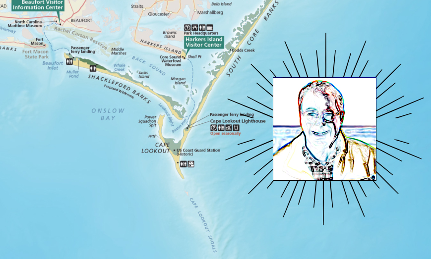
National Park Service Cartographer Tom Patterson Talks Landsat
National Park Service cartographer Tom Patterson’s mapmaking process often incorporates information from Landsat.
Landsat 9 Project On Track, U.S. General Accounting Office Assesses
The U.S. General Accounting Office reported on the Landsat 9 satellite project status as part of its 10th annual Quick Look at NASA’s major projects.
Watching A Quarter Century of North American Forest Dynamics with Landsat
Annual maps of the lower-48 United States produced from Landsat satellite data illustrate how these dynamic systems changed from 1986-2010.
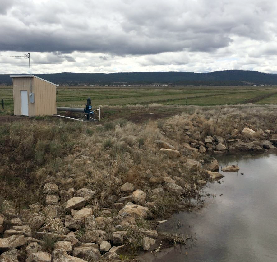
Solving the Riddle of Water Use in the Upper Klamath Basin
When it comes to water, when does less really mean more?
Landsat 9 Successfully Passes Its Critical Design Review
Review board gives high praise to Landsat 9 project for its mission status.
Recent Russian Arctic Glacier Loss Doubles From the Previous 60 Years
Geophysicists examining glacier changes in the Russian Arctic have found that the rate of ice mass loss has nearly doubled over the last decade when compared to records from the previous 60 years.
Supraglacial Lakes Are Not Destabilizing Greenland’s Ice Sheets, Yet
Using Landsat 8 satellite images from 2014 to 2016, researchers have discerned when the lakes on Greenland’s Petermann ice tongue formed, their movement, and changes in surface extent across time.
In Focus: A Peek at Landsat 9's OLI-2 Instrument During Focal Plane Integration
Ball Aerospace recently shared some photos of its technicians working on OLI-2 in the cleanroom during focal plane integration.
Satellites Reveal Major Shifts in Global Freshwater
Earth’s wet land areas are getting wetter and dry areas are getting drier due to a variety of factors, including human water management, climate change and natural cycles.
National Park Service Cartographer Tom Patterson Talks Landsat
National Park Service cartographer Tom Patterson’s mapmaking process often incorporates information from Landsat.
Landsat 9 Project On Track, U.S. General Accounting Office Assesses
The U.S. General Accounting Office reported on the Landsat 9 satellite project status as part of its 10th annual Quick Look at NASA’s major projects.
Watching A Quarter Century of North American Forest Dynamics with Landsat
Annual maps of the lower-48 United States produced from Landsat satellite data illustrate how these dynamic systems changed from 1986-2010.
Solving the Riddle of Water Use in the Upper Klamath Basin
When it comes to water, when does less really mean more?
Landsat 9 Successfully Passes Its Critical Design Review
Review board gives high praise to Landsat 9 project for its mission status.
Recent Russian Arctic Glacier Loss Doubles From the Previous 60 Years
Geophysicists examining glacier changes in the Russian Arctic have found that the rate of ice mass loss has nearly doubled over the last decade when compared to records from the previous 60 years.
