
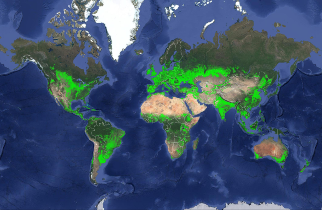
New Landsat-Based Map of Worldwide Croplands Supports Food and Water Security
A new map was released today detailing croplands worldwide in the highest resolution yet.

Uncharted Exhibit in Sioux Falls
Uncharted, a cartographic art installation, was on display for the 2017 Pecora 20 in Sioux Falls, South Dakota.
Significant Milestone in Improving Usability of Landsat Satellite Data
Improvements to the quality and usability of Landsat satellite data have been made with the release of a new USGS product called Landsat Analysis Ready Data.
Researchers Explore Causes of Land Cover Change in African Savannas
This study examined Landsat satellite data from the past 30 years to track broad land cover change in the Chobe district of Northern Botswana.
Landsat Talks—The Karkheh River as Seen by Landsat 1993-2002
Dr. Alan Belward describes water changes around Iran’s Karkheh River between 1993-2002.
Tracking Forest Change in Canada
Researchers used a time series of data from Landsat satellites to quantify areas burned or harvested across Canada.
Landsat 8 Thermal Data Ghost-Free After Stray Light Exorcism
Montanaro and Gerace’s stray light “exorcism” has now placed the Landsat 8 thermal bands in-line with the accuracy of the previous (ghost-free) Landsat thermal instruments.
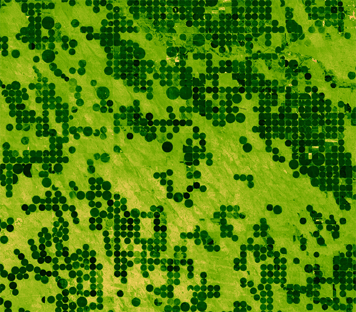
How Much Water Flows into Ag Irrigation? Landsat Knows
Researchers detail their use of satellite images to produce annual maps of irrigation.
New Landsat-Based Map of Worldwide Croplands Supports Food and Water Security
A new map was released today detailing croplands worldwide in the highest resolution yet.
Uncharted Exhibit in Sioux Falls
Uncharted, a cartographic art installation, was on display for the 2017 Pecora 20 in Sioux Falls, South Dakota.
Significant Milestone in Improving Usability of Landsat Satellite Data
Improvements to the quality and usability of Landsat satellite data have been made with the release of a new USGS product called Landsat Analysis Ready Data.
Researchers Explore Causes of Land Cover Change in African Savannas
This study examined Landsat satellite data from the past 30 years to track broad land cover change in the Chobe district of Northern Botswana.
Landsat Talks—The Karkheh River as Seen by Landsat 1993-2002
Dr. Alan Belward describes water changes around Iran’s Karkheh River between 1993-2002.
Tracking Forest Change in Canada
Researchers used a time series of data from Landsat satellites to quantify areas burned or harvested across Canada.
Landsat 8 Thermal Data Ghost-Free After Stray Light Exorcism
Montanaro and Gerace’s stray light “exorcism” has now placed the Landsat 8 thermal bands in-line with the accuracy of the previous (ghost-free) Landsat thermal instruments.
How Much Water Flows into Ag Irrigation? Landsat Knows
Researchers detail their use of satellite images to produce annual maps of irrigation.
