
 Landsat 8 (formerly the Landsat Data Continuity Mission, LDCM), a collaboration between NASA and the U.S. Geological Survey, provides moderate-resolution (15 m–100 m, depending on spectral frequency) measurements of the Earth’s terrestrial and polar regions in the visible, near-infrared, short wave infrared, and thermal infrared.
Landsat 8 provides continuity with the more than 40-year long Landsat land imaging data set. In addition to widespread routine use for land use planning and monitoring on regional to local scales, support of disaster response and evaluations, and water use monitoring, Landsat 8 measurements directly serve NASA research in the focus areas of climate, carbon cycle, ecosystems, water cycle, biogeochemistry, and Earth surface/interior.
++ Important TIRS calibration notice from USGS, April 25, 2017: “Stray light from far out-of-field has affected the Landsat 8 Thermal Infrared Sensor (TIRS) absolute calibration since launch. An algorithm to correct for this issue was developed and implemented into the processing system in February 2017.”
Additionally, Landsat 8 is required to return at least 400 scenes per day to the USGS data archive (150 more than Landsat 7), increasing the probability of capturing cloud-free scenes for the global landmass. Recently, Landsat 8 has been acquiring ~725/day and Landsat 7 has been acquiring ~470 scenes/day. That’s ~1195 new Landsat scenes per day into the USGS Landsat archive!
LDCM (Landsat 8) Communications Toolkit
- Download LDCM Toolkit PC (228 MB)
- Download LDCM Toolkit Mac (200 MB)
Landsat 8 Status and Launch Date
Landsat 8 is operating normally after its successful launch on February 11, 2013. Landsat 8 data are freely available from the USGS.
- Download LDCM Launch Brochure
- Download LDCM Brochure (with spectral band table)
NASA and USGS Roles
The Landsat 8 mission is a partnership between NASA and USGS that builds upon a strong relationship developed during previous Landsat missions. NASA’s expertise in Earth observation missions and USGS’s expertise in data archives and remote sensing data processing provides for a mutually beneficial partnership.
NASA’s Landsat 8 responsibilities include development of the OLI and TIRS instruments, spacecraft, launch vehicle, implementation of the USGS-funded Mission Operations Element, and mission on-orbit verification. NASA acquired most elements of the space segment from industry with Goddard Space Flight Center (GSFC) acting as the mission integrator and leading mission systems engineering.
TIRS was built in-house at GSFC and launch services were provided by Kennedy Space Center. The Landsat 8 mission operations center is at GSFC. USGS is providing the ground data processing systems which are located at the USGS Earth Resources Observation and Science (EROS) center.
USGS acquired the ground data processing systems from industry. The flight operations team is also provided by USGS through an existing NASA contract. USGS funds and leads the Landsat science team. Upon completion of on-orbit verification, USGS began to lead post-launch calibration activities, satellite operations, data product generation, and data archiving.
LDCM Launch Vehicle
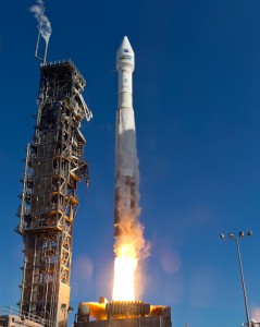 Launch services were provided by the NASA Kennedy Space Center (KSC). The launch vehicle was an Atlas-V rocket and was managed by KSC and procured from United Launch Alliance.
LDCM Ground System
The LDCM Ground System includes all of the ground-based assets needed to operate the LDCM observatory. The primary components of the Ground System are the Mission Operations Element, Collection Activity Planning Element, Ground Network Element, and the Data Processing and Archive System.
The Missions Operations Element (MOE) was provided by the Hammers Corporation. The MOE contract was awarded in September 2008. The MOE provides capability for command and control, mission planning and scheduling, long-term trending and analysis, and flight dynamics analysis. The overall activity planning for the mission is divided between the MOE and Collection Activity Planning Element (CAPE). The CAPE schedules activities on a path-row scene basis. The MOE converts CAPE-generated path-row scenes to observatory activities, schedules these and any other detailed observatory activities, and generates commands necessary to collect the identified scenes and operate the observatory. The Ground Network Element (GNE) is comprised of two nodes located at Fairbanks, Alaska and Sioux Falls, SD. Each node in the GNE includes a ground station that will be capable of receiving Landsat 8 X-band data.
Additionally, each station provides complete S-band uplink and downlink capabilities. The Data Processing and Archive System (DPAS) includes those functions related to ingesting, archiving, calibration, processing, and distribution of Landsat 8 data and data products. It also includes the portal to the user community. The Ground System, other than the MOE, is developed by USGS largely through their support service contract.
Learn about the Landsat Legacy project
NASA and USGS Roles
The Landsat 8 mission is a partnership between NASA and USGS that builds upon a strong relationship developed during previous Landsat missions. NASA’s expertise in Earth observation missions and USGS’s expertise in data archives and remote sensing data processing provides for a mutually beneficial partnership.
NASA’s Landsat 8 responsibilities include development of the OLI and TIRS instruments, spacecraft, launch vehicle, implementation of the USGS-funded Mission Operations Element, and mission on-orbit verification. NASA acquired most elements of the space segment from industry with Goddard Space Flight Center (GSFC) acting as the mission integrator and leading mission systems engineering.
TIRS was built in-house at GSFC and launch services were provided by Kennedy Space Center. The Landsat 8 mission operations center is at GSFC. USGS is providing the ground data processing systems which are located at the USGS Earth Resources Observation and Science (EROS) center.
USGS acquired the ground data processing systems from industry. The flight operations team is also provided by USGS through an existing NASA contract. USGS funds and leads the Landsat science team. Upon completion of on-orbit verification, USGS began to lead post-launch calibration activities, satellite operations, data product generation, and data archiving.
LDCM Launch Vehicle
Launch services were provided by the NASA Kennedy Space Center (KSC). The launch vehicle was an Atlas-V rocket and was managed by KSC and procured from United Launch Alliance.
LDCM Ground System
The LDCM Ground System includes all of the ground-based assets needed to operate the LDCM observatory. The primary components of the Ground System are the Mission Operations Element, Collection Activity Planning Element, Ground Network Element, and the Data Processing and Archive System.
The Missions Operations Element (MOE) was provided by the Hammers Corporation. The MOE contract was awarded in September 2008. The MOE provides capability for command and control, mission planning and scheduling, long-term trending and analysis, and flight dynamics analysis. The overall activity planning for the mission is divided between the MOE and Collection Activity Planning Element (CAPE). The CAPE schedules activities on a path-row scene basis. The MOE converts CAPE-generated path-row scenes to observatory activities, schedules these and any other detailed observatory activities, and generates commands necessary to collect the identified scenes and operate the observatory. The Ground Network Element (GNE) is comprised of two nodes located at Fairbanks, Alaska and Sioux Falls, SD. Each node in the GNE includes a ground station that will be capable of receiving Landsat 8 X-band data.
Additionally, each station provides complete S-band uplink and downlink capabilities. The Data Processing and Archive System (DPAS) includes those functions related to ingesting, archiving, calibration, processing, and distribution of Landsat 8 data and data products. It also includes the portal to the user community. The Ground System, other than the MOE, is developed by USGS largely through their support service contract.
Learn about the Landsat Legacy project
