
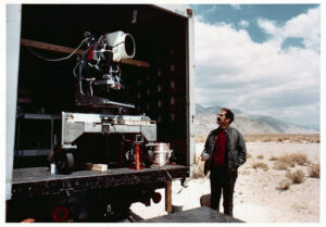
MSS You! Photos from a 1972 Road Trip
Two months before the launch of Landsat 1, the engineering model of the satellite’s multispectral scanner system went on a California road trip.

A Face Behind Landsat Images: Meet Dr. Valerie L. Thomas
Thomas managed the development of early Landsat image processing software systems and became the resident expert on the Computer Compatible Tapes that were used to store early Landsat imagery.
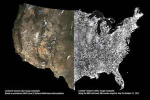
Now & Then: The History of Portrait U.S.A.
USGS released provisional Landsat surface reflectance products in December. Surface reflectance products correct for atmospheric distortions thereby providing “less hazy” images.
Looking at Cranberry Bogs with Landsat
Whether it’s cranberry relish, cranberry fluff, cranberry sauce, cranberry salad, or cranberry salsa you’ll be enjoying today, it’s fun to see where cranberries grow. A series of commercial cranberry beds can be seen on this Oct. 6, 1999 Landsat 7 image.
Over 20 Million Landsat Scenes Downloaded
Since 2008, all Landsat data—archived and newly acquired—have been available for free download. On September 16, 2014, users worldwide downloaded over 14,000 scenes from the servers at the USGS Earth Resources Observation and Science (EROS) Center. These downloads brought the total number of Landsat data downloads to more than 20 million.
Looking Back—The Millionth MSS Image
This Landsat (MSS) image, acquired by Landsat 2 on May 27, 1981 (WRS-1 Path 186 Row 26), marks the one-millionth MSS image acquired by the Landsat satellites. The image covers a 115×115-mile (185×185-km) area of the steppe (vast treeless plain) region of southwestern Russia. The large body of water on the south-central portion of the image is the Tsimlyanskoye reservoir, located approximately 60 miles (96 km) west of Volgograd (formerly Stalingrad) and 550 miles (885 km) south of Moscow.
