
Presentation title:
Environmental changes and microbiological health risks. Satellite-derived turbidity: an indicator of “health hazard” for surface water in West Africa (Bagre Lake, Burkina Faso).
What are the major findings of your research?
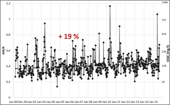
The NIR/Red reflectance ratio employed in this study allowed monitoring the turbidity and Surface Suspended Sediments Concentration (SSSC) of the Bagre Lake (Burkina Faso) up to the high values typically encountered in most of West Africa.
The results highlighted the strong link between turbidity, precipitation and land cover (vegetation fraction) with increasing turbidity from the early rainy season to the mid-season. In addition, the spatio-temporal analysis of the NIR/Red index in the different areas of the lake revealed the sediments are primarily transported from upstream to downstream areas between June and September (and not related to resuspension of lake sediments). A significant turbidity increase of about 20% was observed between 2000 and 2015, especially for the months of August to December.
What insight did you gain from Landsat that would have been impossible to glean otherwise?
The results for Landsat are preliminary. We confirm that the NIR/Red ratio (turbidity index) is well correlated with SSSC measured in situ. We hope that we will be able to document the spatial variations of turbidity and thus to better identify and map health hazard: areas where turbidity is high, as well as to document the resuspension processes and the impact of the lake tributaries.
How were MODIS, Landsat 7/8, and SPOT5 data used?
The study of turbidity (health hazard) requires a space-time monitoring to fine scale. MODIS is used to study the temporal variations, and Landsat 7/8 and SPOT5 Take 5 are used to study spatial variations.
Are you looking forward to using Landsat data together with Sentinel-2a and -2b?
Yes, because this high spatial resolution will permit to map more precisely health hazard (10 m and 5 days). Extension to other small water bodies is currently being performed.
Will your research help people in West Africa?
[Not yet], but we hope that eventually it will help people reduce microbiological health risks.
Co-authors:
Manuela Grippa
CNRS
Laurent Kergoat
GET Géosciences Environnement Toulouse
Jean_Michel Martinez
IRD Institute for Research and Development
Sylvain Pinet
CNES French National Center for Space Studies
Laetitia Gal
CNRS
Nogmana Soumaguel
IRD Institute for Research and Development
Anyone can freely download Landsat data from the USGS EarthExplorer or LandsatLook.
Further Reading:
+ Landsat at #AGU15


