
Ensuring the health and sustainability of the nation’s forests requires scientifically credible and timely information about the extent, location, health, and ownership of these forests and the possible effects of global climate change. Forest managers and policy makers need detailed data to assess sustainability, to make important business decisions, to evaluate wildlife habitat, and for many other things. The Northern Research Station’s Forest Inventory and Analysis (FIA) team provides information on northeastern, midwestern, and Great Plains forests.
Linking Land Use to Great Lakes Water Quality
Prioritizing investment of restoration dollars by predicting which watersheds will contribute to impaired water quality
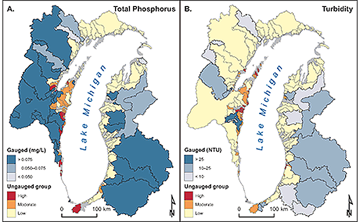
In the Lake Superior basins, phosphorus output increased with the amount of land used for agriculture, recent forest disturbance, and persisting forest cover; turbidity measurements increased with recent forest disturbance, the amount of land in agriculture, persisting forest, and urban land.
In the basins draining into Lake Michigan, phosphorus output was related to ecoregion, increased with urban land, and decreased with older forest disturbance and watershed storage; turbidity measurements increased in some ecoregions and with recent forest disturbance, and decreased as the amount of conifer forest increased.
Forest Service scientists used these relationships to identify and prioritize restoration areas in watersheds without observed in-stream data. This prioritization of watersheds will aid effective management of the Great Lakes Watershed and result in efficient use of restoration funds, leading to improved near-shore water quality.
Forest Land Estimates Improved by Novel Automated Mapping Technique Using Winter Satellite Imagery
New satellite-based estimates are consistent with plot-based data and suitable for filling the gaps between plots
Most automated satellite-based approaches for mapping forest lands rely on summer satellite imagery and are usually inconsistent with FIA plot-based estimates. Incorporating winter imagery in the mapping approach helps reduce the abundant false positives for forest and forest disturbance that frequently occur during the growing season, especially where forest is intermixed with wetland and agricultural landscapes.
Forest Inventory and Analysis (FIA) plot data provide invaluable information about the distribution and health of our nation’s forests to scientists and the public alike. Reliable estimates of forest lands between FIA field plots allow customers the opportunity to explore forest dynamics more confidently beyond the grid of FIA plots.
Forest Service scientists found that winter satellite imagery with the vegetation change tracker (VCT) could generate more reliable estimates of forest lands in the western Great Lakes area. These VCT data were consistent with those from plots.
The VCT is an automated forest mapping algorithm that exploits the Landsat archive to produce comprehensive maps of forest changes and is well-suited for filling in data gaps between FIA plots. Using winter imagery exploited sharp seasonal contrasts of forested and nonforested areas and enabled the removal of most false positives, providing an efficient and reliable option for filling in gaps between FIA plots. False positives for forest and forest disturbance are a serious problem for the gaps in many FIA data grids, especially in intermixed forest and wetland and agricultural landscapes.
Further Information:
+ Forest Service—Northern Research Center Research Highlights – Inventory, Monitoring, and Assessment


