[By Jon Campbell, U.S. Geological Survey] Orbiting Earth more than 400 miles away in space, far from human view; recording repeated images of land around the globe for more than 42 years; offering customers petabytes of historical and current data for free, the Landsat program of Earth observing satellites could be seen as the personification of the most single-minded office worker — tirelessly systematic, yes, but after so many years, perhaps less than dramatic.
What does that worker actually contribute after more than four decades on the job? Is he, she – in this case, it – still relevant to today’s market? What is the real value of the work?
Taking a hard look at the value of Landsat to the U.S. economy has been the ambitious goal of the Landsat Advisory Group of the National Geospatial Advisory Committee. This team of commercial, state/local government, and NGO geospatial information experts recently updated a critical review of the value of Landsat information that has recently been released to the public.
The bottom line to begin
What did this team of leading experts from places like Google, ESRI, and Stanford University find? Here is the bottom line at the top.
The economic value of just one year of Landsat data far exceeds the multi-year total cost of building, launching, and managing Landsat satellites and sensors.
This would be considered a stunning return on investment in any conventional business setting.
Read on to learn how the team came to this conclusion.
About Landsat
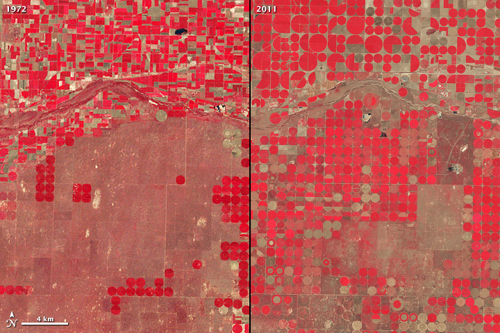
First launched in 1972, the Landsat series of satellites has produced the longest, continuous record of Earth’s land surface as seen from space. Carefully calibrated Landsat imagery provides the U.S. and the world with a long-term, consistent inventory of vitally important global resources.
Landsat images have been used by scientists and resource managers to monitor water quality, glacier recession, coral reef health, land use change, deforestation rates, and population growth. To give a few examples of Landsat’s many commercial applications, Landsat data has used to track the use of irrigation water, to assist drought-stricken California grape growers, and to contribute to the success of a forestry start-up company.
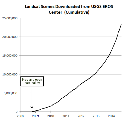
Landsat is a joint effort of USGS and NASA. NASA is in charge of developing remote-sensing instruments and spacecraft, launching the satellites, and validating their performance. USGS develops the associated ground systems, then takes ownership and operates the satellites, as well as managing data reception, archiving, and distribution. Since late 2008, when Landsat data was made available to all users free of charge, over 22 million Landsat scenes have been downloaded through the USGS-EROS website – and the rate of downloads is still increasing.
Prior studies
The Landsat Advisory Group reviewed previous studies of the value of Landsat. In 2013, the National Research Council found, “The economic and scientific benefits to the United States of Landsat imagery far exceed the investment in the system.” This conclusion echoed the results of studies done in 2007 by the American Society of Photogrammetry and Remote Sensing and in 2012 by Booz Allen Hamilton at the request of USGS.
These studies were followed by a report by the USGS in 2013, which featured a survey of 11,275 Landsat users on the uses and value of Landsat satellite imagery. This customer-oriented investigation found that the economic benefit of Landsat data for the year 2011 alone was estimated to be $1.70 billion for U.S. users and $400 million for international users resulting in a total annual value of $2.19 billion.
The value of free data: comparing apples to what?
Even though directly observed information about the Earth from Landsat is recognized around the globe as crucial to science, resource management, commerce, agriculture, and education, how does one begin to quantify the worth of free data? Further, these free data are often used for produce broad societal benefits, such as scientific research or the mitigation of natural hazards. Such benefits are particularly difficult to measure.
The Landsat Advisory Group tackled that challenge by considering the costs of alternatives to Landsat for current uses of the data. People use Landsat because it is more efficient than some other technology to accomplish the same decision support requirement. How would the information that Landsat provides be acquired if Landsat did not exist?
The team of experts outlined sixteen decision processes that would be significantly more expensive without an operational Landsat-like program. Many of these processes are associated with the U.S. government and save significant amounts of money compared to other methods of accomplishing the same objective. They also include non-governmental science applications where scarce research dollars cannot be wasted on inefficient technologies.
In conclusion
Landsat Applications and their Estimated Annual Efficiency Savings
1. USDA Risk Management Agency → over $100 million
2. U.S. Government Mapping → over $100 million
3. Monitoring Consumptive Agricultural Water Use → $20–$80 million
4. Monitoring Global Security → $70 million
5. Landsat Support for Fire Management → $28–$30 million
6. Forest Fragmentation Detection → over $5 million
7. Forest Change Detection → over $5 million
8. World Agriculture Supply and Demand Estimates → over $3–$5 million
9. Vineyard Management and Water Conservation → $3-$5 million/year
10. Flood Mitigation Mapping → over $4.5 million
11. National Agricultural Commodities Mapping → $1.9 million/year
12. Waterfowl Habitat Mapping and Monitoring → $1.9 million/year
13. Coastal Change Analysis Program → $1.5 million
14. Forest Health Monitoring → $1.9 million/year
15. NGA Global Shoreline → over $90 million (one time)
16. Wildfire Risk Assessment → $25-$50 million (one time)
These sixteen Landsat applications alone produce savings of $350 million to over $436 million per year for Federal and State governments, NGO’s, and the private sector. Further annual savings, societal benefits, and commercial applications are described in the Landsat Advisory Group report.
Estimated Productivity Savings from Uses of Landsat
Landsat is widely considered to be a crucial national asset, comparable to the satellite-based GPS system and National Weather Service satellites. Ready access to Landsat images supplies a reliable common record of Earth conditions that fosters the mutual understanding of environmental challenges by citizens, researchers, and decision makers worldwide.
The long, consistent view of Earth from space provided by Landsat sparks advances in science, enables more efficient natural resources management, and promotes profitable applications of the data in commerce and industry. In step with the National Research Council and other objective reviews, the non-federal Landsat Advisory Group has found that the broad benefits of Landsat far outweigh the cost.
Note: The Landsat Advisory Group is a subcommittee of the National Geospatial Advisory Committee, which is chartered under the Federal Advisory Committee Act (1972) to provide advice and recommendations related to the management of federal and national geospatial programs.