Now & Then: The History of Portrait U.S.A.
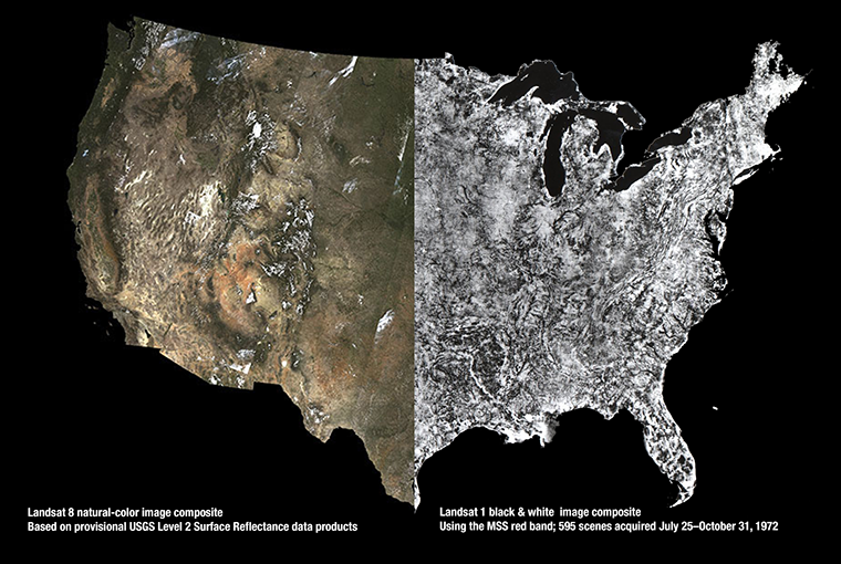
USGS released provisional Landsat surface reflectance products in December. Surface reflectance products correct for atmospheric distortions thereby providing “less hazy” images.

USGS released provisional Landsat surface reflectance products in December. Surface reflectance products correct for atmospheric distortions thereby providing “less hazy” images.
When viewed from space, clouds largely obscure the Earth. It isn’t a matter of time of day, angle or distance. It’s just the way it is – unless, of course, you are gazing at the planet using Google Earth. The story of how Google Earth offers images of the planet — without letting clouds get in the way — began in the foothills of the Santa Cruz Mountains in California.
On December 19 the TIRS instrument on Landsat 8 was reconfigured due to detection of anomalous current levels associated with the scene select mirror encoder electronics. Since that time substantial testing has been conducted to isolate the root cause of the problem and to evaluate options for returning to routine operations.
Turkana County in northwest Kenya has been reeling from several years of crippling drought. As a consequence, the nomadic peoples in the region have suffered. Livestock such as goats and cattle, the sole source of income for these pastoralists, have perished by the droves from starvation, and the resulting economic hardship has left many children malnourished. Many have also died from violent clashes over increasingly scarce resources.
The NASA Landsat 7 Project Scientist, Darrel Williams, was recently featured in the AgScience magazine of his alma mater. In an article titled “Oh! The Places We Go” reporter Maureen Harmon spoke to Penn State Ag Sciences graduates about the different directions of their careers.
Orbiting Earth more than 400 miles away in space, far from human view; recording repeated images of land around the globe for more than 42 years; offering customers petabytes of historical and current data for free, the Landsat program of Earth observing satellites could be seen as the personification of the most single-minded office worker — tirelessly systematic, yes, but after so many years, perhaps less than dramatic.
The United States Geological Survey (USGS) and the International Society for Photogrammetry and Remote Sensing (ISPRS) presented a number of prestigious awards during the Pecora 19 Symposium in conjunction with the Joint Symposium of ISPRS Technical Commission I and IAG Commission 4 in Denver, Colorado, November 17 – 20, 2014.
