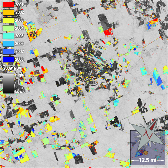
In a recent EarthSky interview, NASA Goddard scientist Doug Morton talks about the importance of Landsat data to carbon accounting and potential policies.
Podcasts:
• 90 second podcast interview (1.7 Mb)
• 8 min. podcast interview (13.9 Mb)
From EarthSky:
Doug Morton: To my knowledge, this is the first time we’re talking about negotiating an international agreement that’s fundamentally based on our ability to use the satellite data.
Doug Morton, of NASA’s Goddard Space Flight Center, is talking about how images taken by the Landsat satellite are being used as the scientific basis for an agreement that will be under negotiation at the U.N. Climate Change Conference in December 2010. The agreement is called REDD, for reducing emissions from deforestation and forest degradation – specifically, in tropical forests.
Doug Morton: Broadly speaking, its goals are to use market mechanisms – essentially paying countries to do the right thing – for either reducing their rates of deforestation or degradation. Degradation largely refers to logging, forest fires, and even fuel wood collection that occurs in tropical forests.
Morton uses Landsat images spanning forty years to see where forests are cleared, and whether they’ve grown back. Tropical forests store a huge amount of carbon, and Morton’s research suggests that deforestation is responsible for 12% of all greenhouse gas emissions from human activity. Morton said if REDD is included in a new climate treaty, Landsat and other satellites will be used to monitor countries’ progress in cutting their rates of deforestation.
Doug Morton: Fundamentally, we have to be able to know whether the rates of forest changes have increased or decreased, compared to past periods. And that’s where the Landsat archive comes into play. REDD, also called REDD+, is being negotiated at COP 16 from November 29 – December 10, 2010, in Cancun, Mexico.
Doug Morton: It’s really one of the areas of new negotiations for the UN climate change-related agreements. REDD is breaking new ground in its effort to bring in a new source of carbon mitigation for folks working on this issue of climate change mitigation in general.
Morton explained the idea behind REDD. The clearing of forests in tropical countries is driven by market forces, or the demand for forest land and products. Economic incentives offered by the international community for conserving forests would help deter deforestation.
Doug Morton REDD is trying to incentivize countries to take actions conserve tropical forests, to enhance the carbon stocks in those forests, and to promote things like sustainable forest management that would allow tropical forests to maintain their benefits for mitigating climate change.
Morton is able to monitor tropical forests using Landsat images. Each pixel of a Landsat image represents a fourth of an acre, he said, approximately the size of the smallest piece of land managed for agriculture in tropical forests. Many areas of new deforestation are much larger, and therefore easily mapped using Landsat data, Morton said.
Doug Morton: I use time series of Landsat data. Essentially that means that I take one satellite image each year, and I stack those up to look at the way in which an area changes through time. So the goal of my work is to look at when and how areas cleared, how long they’re used for agriculture, and if they’re abandoned, do they return to forests?
He said that Landsat’s ability to accurately distinguish land use from space makes it a valuable tool for monitoring countries’ progress, if REDD is included in the United Nations climate treaty.
Our thanks today to the NASA and USGS Landsat Program, creating an unparalleled record of Earth’s changing landscapes.
Source: Lindsay Patterson, EarthSky [external link]
Further Information:
+ EarthSky [external link]

Be Part of What’s Next: Emerging Applications of Landsat at AGU24
Anyone making innovative use of Landsat data to meet societal needs today and during coming decades is encouraged to submit and abstract for the upcoming “Emerging Science Applications of Landsat” session at AGU24.


