
The Hyperion Treatment Plant in Playa del Rey, California, is operated by the City of Los Angeles’ Bureau of Sanitation. The plant serves all of Los Angeles and several other cities, processing 258 million gallons (9.8 million liters) of sewage daily on average. Like many other wastewater plants on the California coast, Hyperion discharges treated wastewater, or effluent, into the Pacific Ocean. For more than 50 years, that effluent has flowed through a pipe that terminates 5 miles (8 kilometers) offshore in the Santa Monica Bay at a depth of 187 feet (57 meters), where it mixes and disperses in deeper seawater. Routine monitoring has shown that the effluent from this long pipe does not disperse into recreational waters near the shore.
Last fall, however, this discharge pipe had to be shut down for repairs for six weeks. The treated effluent was diverted to an older pipe that terminates 1 mile (1.6 kilometers) offshore, 49 feet (15 meters) deep. In shallower, warmer water, nutrients from the effluent plume are more likely to enhance phytoplankton growth, among other risks to water quality.
To keep a closer-than-usual watch on the bay during this diversion, LA’s Environmental Monitoring Division called on the research institutions that comprise the Southern California Coastal Ocean Observing System (SCCOOS), including NASA’s Jet Propulsion Laboratory, Pasadena, California. SCCOOS is one of 11 national observing groups that collect scientific data along the coastline to inform decision-making and better understand the changing conditions of the coastal ocean. JPL provided measurements related to the effluent plume and algal growth from five satellite instruments, in coordination with the Environmental Monitoring Division and other local research institutions collecting data from shore and ships.

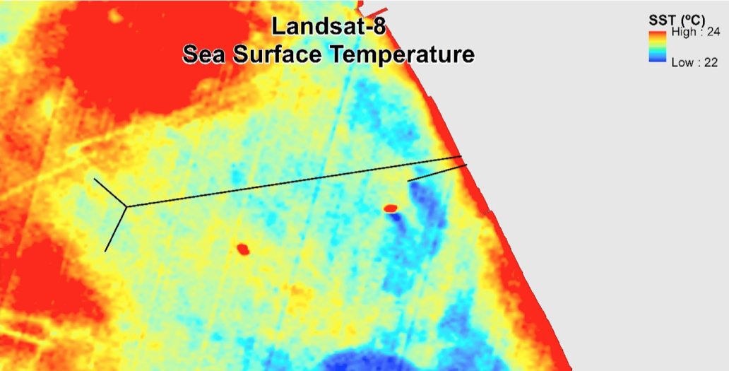
The JPL group used images from the Advanced Spaceborne Thermal Emission and Reflection Radiometer (ASTER) instrument on NASA’s Terra satellite, the Moderate Resolution Imaging Spectrometer (MODIS) instrument on NASA’s Aqua satellite, Landsat-8, and European and Japanese satellites. The instruments provided information on the temperature and roughness of the sea surface and the presence of chlorophyll and microscopic particles in the water that alter its clarity.
By combining the remotely sensed observations with shipboard measurements, the scientists were able to make an accurate assessment of the extent of the diverted wastewater plume and its impact on Santa Monica Bay and its shoreline.
Curtis Cash, a water biologist for the city of Los Angeles, gave an example of how he used the satellite data to better understand how the effluent plume was affecting coastal waters. Patches of blooming algae were initially spotted by observers at ground level. “Satellite imagery revealed that the bloom was far more widespread than [we] thought, which may suggest that it initiated and developed regionally and naturally, rather than [being] driven by our effluent plume,” he said. The plume might, or might not, have amplified or catalyzed a natural event, Cash added.
Cash sees value in satellite observations for the Environmental Monitoring Division’s regular monitoring. “We will rely on future chlorophyll imagery to assist in guiding our boat-based sampling,” he said. “If there are indications of an emergent phytoplankton bloom in a particular geographic area of the Santa Monica Bay, we can allocate our resources to that area so that we can monitor the evolution of that bloom as efficiently and extensively as possible.”
Holt noted that the diversion was also an opportunity for the NASA team to better understand the value of the different satellite images in studying offshore waters. “From the NASA point of view, it’s a unique case of a really good coastal marine application of these assets.”
For further information contact:
Alan Buis
Jet Propulsion Laboratory, Pasadena, California
818-354-0474
Alan.Buis@jpl.nasa.gov

Be Part of What’s Next: Emerging Applications of Landsat at AGU24
Anyone making innovative use of Landsat data to meet societal needs today and during coming decades is encouraged to submit and abstract for the upcoming “Emerging Science Applications of Landsat” session at AGU24.


