
Source: NASA’s Applied Sciences Program
Along Antarctica’s coastline, marine mammals, seabirds, and aquatic life thrive in the icy, krill-rich waters of the Southern Ocean. One of many species that depends on krill for their diet, Adélie penguins are distributed around the Antarctic coast and nest in some the world’s most remote places.
As the krill goes, so does the Adélie; and scientists have long used these penguins as an early-warning signal for the ocean’s ecological health. More recently, global companies have also turned to these squat swimmers to guide their Antarctic operations—and a tool we helped support is now connecting these unlikely partners.
A Bird’s Eye View (of Poo)
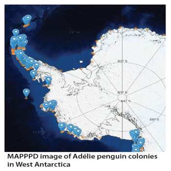
That tool is MAPPPD, or Mapping Application for Penguin Populations and Projected Dynamics. Conservation foundation Oceanites, Inc., partnered with Heather Lynch of Stony Brook University and Mathew Schwaller of NASA Goddard to create this online database. MAPPPD is the first free, open-access Antarctic decision support system that integrates remotely sensed inputs, such as Landsat 7 images and MODIS sea ice data, to provide an assessment of Adélie and other penguin species across the frozen continent.
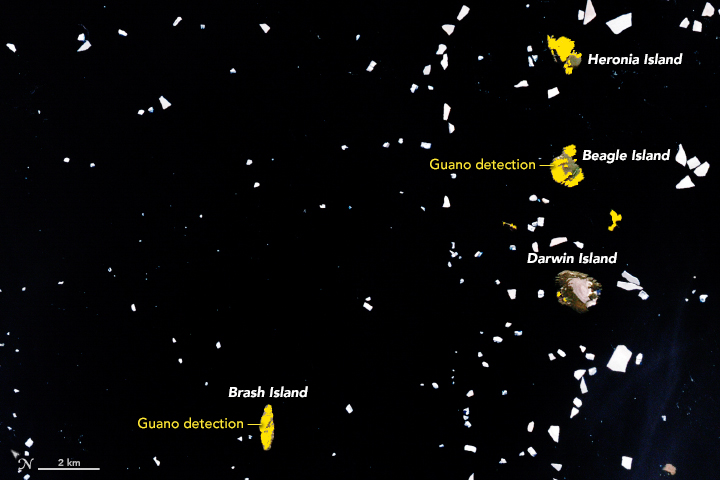
How does a satellite like Landsat monitor the whereabouts of small, aquatic birds? It detects the ‘signature’ of their excrement.
“Satellite–based penguin surveys are detecting the guano left behind by penguins nesting at the colony,” Lynch explained. “Male and female penguins take turns incubating the nest…and the guano left behind builds up in exactly the same areas occupied by the nests themselves.
We can use the area of the colony (as defined by the guano stain) to work back to the number of pairs that must have been inside the colony.”
With these “poo views”, MAPPPD automatically classifies penguin areas, generates abundance estimates, and pushes those to the database so models can be updated in real time. And it includes more than just satellite data. “MAPPPD also continues to serve as a hub for ground-based surveys, and for data coming from citizen science efforts,” said Lynch.
For conservationists, businesses, and other Antarctic stakeholders, this penguin information is crucial for ensuring they conduct their operations with as little impact as possible on the Southern Ocean and Antarctic ecosystem. By knowing where these flightless waterfowl are located, they know where to minimize their presence—and MAPPPD is helping direct them.
Penguins Providing Guidance
The Association of Responsible Krill harvesting companies (ARK) is composed of five international companies that rely on sustainably harvested Antarctic krill for their products. It’s also a user of MAPPPD.
ARK companies announced this year that they have voluntarily halted fishing in waters near MAPPPDindicated penguin colonies. “Leaving enough prey for natural krill predators is an important element in ensuring fisheries proceed sustainably,” Lynch emphasized. “Without up-to-date knowledge on the locations of penguin colonies, ARK companies cannot possibly avoid the colonies, even if they agreed to do so.”
One of the founding members of ARK is Aker BioMarine. It is a Norwegian-based company that recently built a new manufacturing plant in Houston, Texas. “We opened the U.S. facility because it gave us a more central location for global distribution,” said CEO Matts Johansen. This Houston facility is helping support a booming international krill oil market—a market that depends on responsible harvesting to survive. “Aker BioMarine works closely with Oceanites and MAPPPD,” Johansen added. “A long-term and sustainable fishery is the best way to ensure the future of the krill fishery and their operations in the Antarctic.”
The International Association of Antarctica Tour Operators (IAATO), headquartered in Newport, Rhode Island, also uses MAPPPD to guide its environmentally-responsible Antarctic excursions. IAATO operators work on the principle that tourism, when managed effectively, is a powerful conservation tool. IAATO turns to MAPPPD to help tailor its tours so they have a minimal impact on the ecosystem.
“The bulk of our operations are in the Antarctic Peninsula area where there is a lot of overlapping human activity and where there has been a lot of environmental change,” noted Amanda Lynnes, IAATO’s communications and environmental officer. “We recognize that long term monitoring projects are vital for detecting change, and MAPPPD now makes these critical data sets accessible to a wide audience.”
Mapping What’s Ahead Lynch’s review of various Landsat surveys has also led to a new finding. “While Adélie populations have declined, and continue to decline on the Antarctic Peninsula, they are actually increasing in abundance in the Ross Sea and in Eastern Antarctica,” she said. “It appears that these gains are at least cancelling and perhaps even more than compensating for losses on the Peninsula.”
And as these penguin populations shift, MAPPPD will keep guiding Antarctic stakeholders. “MAPPPD will help the Antarctic community, including IAATO, manage human activity,” Lynnes added. “This must always be a collaborative effort.”
For Lynch, the possibilities for MAPPPD are just beginning: “With all the new data streaming in from satellites, and a new approach to sharing data and models through MAPPPD, I’m extremely optimistic we can start making some real progress on these long-standing puzzles in Antarctic ecology.”
Heather Lynch at Stony Brook leads this project.
Further Reading:
+ Penguin Droppings Are Fertile Ground for Science, NASA Earth Observatory
+ Check out MAPPPD here: www.penguinmap.com


