Category: Human Health

News Archive
The Philippines’ famed Banaue Rice Terraces, pictured here

Future Grains

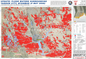
When global food prices spiked dramatically in late 2007 and into 2008, the costs of many basic dietary staples doubled or even tripled around the world, sparking protests and riots. Panicked governments stopped exporting food, aggravating the crisis.

Read More »

Monitoring Small Surface Water Bodies in Africa

Naga Manohar Velpuri, works with the USGS Famine Early Warning Systems Network (FEWS NET). The project has recently initiated a large-scale project to monitor surface water bodies in the pastoral regions of Africa using multi-source satellite data and hydrologic modeling techniques. Currently, a total of 293 water points are being monitored in 10 countries. Velpuri shared some of the projects findings he presented at #AGU15.

Read More »

Detecting Landslides in Nepal with Landsat

Justin Roberts-Pierel from the Joint Center for Earth Systems Technology, uses Landsat 8 to detect landslides in the Himalayas. He provided information about his studies at #AGU15. We talked with him about his work.

Read More »

Landsat Images Advance Watershed Restoration in Western Tanzania

For those who live along its shores, Lake Tanganyika in east Africa is the backbone of local transportation and serves as an essential source of household water and protein. Every night, fishers lure nocturnal, sardine-like fish called dagaa with compression lamps that are strung between their boats. From the shore, the lake sparkles with the lights of miniature moons as people gather the treasured catch.

Read More »

Water Mapping Technology Rebuilds Lives in Arid Regions

Turkana County in northwest Kenya has been reeling from several years of crippling drought. As a consequence, the nomadic peoples in the region have suffered. Livestock such as goats and cattle, the sole source of income for these pastoralists, have perished by the droves from starvation, and the resulting economic hardship has left many children malnourished. Many have also died from violent clashes over increasingly scarce resources.

Read More »

Using Landsat to Detect Human Rights Violations

Over 2500 villages were destroyed during six years of conflict in Darfur between 2002 and 2008. Dr. Andrew Marx, a 2013 fellow at the Center for the Prevention of Genocide at the U.S. Holocaust Memorial Museum, has found that this type of destruction—associated with human rights violations—can be detected using freely available Landsat data.

Read More »

Vast Water Reserves Found in Drought-Prone Northern Kenya

Large underground water reserves have been found in Turkana, one of Kenya’s driest and poorest regions. The discoveries were made by the natural resources exploration firm, Radar Technologies International, during the course of a survey of groundwater conducted for the Kenyan Government on behalf of the UN. The aquifers were detected with the WATEX System, RTI’s state-of-the-art, space-based exploration technology.

Read More »