How the 2010 Haitian Earthquake & Resulting Human Migration Affected Landslide Occurrences

How the 2010 Haitian Earthquake & Resulting Human Migration Affected Landslide Occurrences

earthquake aftermath
Aftermath of the 2010 Haitian earthquake.

percent landslide per land cover type
Percentage of post-earthquake landslides for different land cover types for the Port-au-Prince province in 2010. Nearly half of the landslides occurred in barren and sparsely vegetated areas. Image credit: Kato et al.

At #AGU15 Yurika Kato, a Geosciences graduate student at the University of Missouri-Kansas City, presented her research about how the 2010 Haitian earthquake and resulting human migration affected landslide occurrences in the Port-au-Prince province. We spoke with Kato about her research.
Presentation title:
Effects of Earthquake and Human Migration on Land Cover Change and Mass Wasting from the 2010 Haiti Earthquake
What are the major findings of your research?
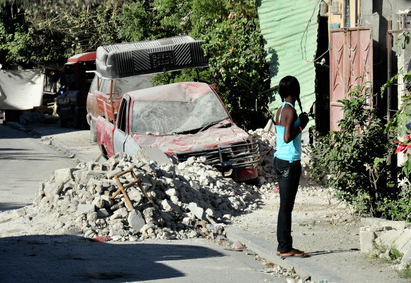
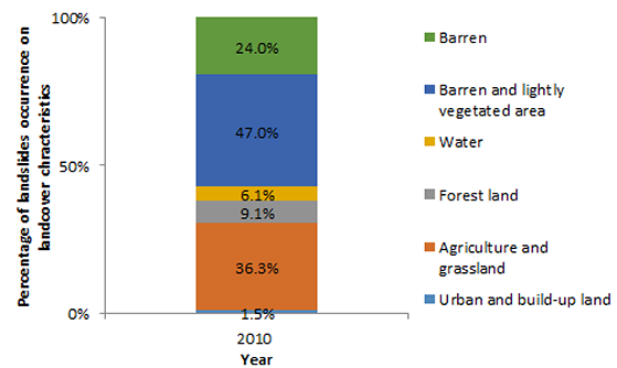
I found that overall landslide events increased, but newer landslide events in each study area showed different trends after the earthquake. Anthropogenic activities did not induce landslides in forested land areas. However, frequently used areas such as agricultural lands, grasslands, and lightly vegetated regions had increased landslides. People who evacuated from Port-au-Prince tended not to disturb forested land, but rather accessible lands such as grasslands and lightly vegetated areas.
What insight did you gain from Landsat that would have been impossible to glean otherwise?
Landsat is an amazing tool for revealing problems on surface of the earth. I have used Landsat images to generate land cover maps for my study areas as well as landslide inventory maps. It would have been very difficult to classify landuse from aerial photographs instead of Landsat images.
Are there ways in which your research will help Haitians?
If observations from this study are utilized in land use planning, there may be a reduction of landslides and that will help the Haitian people avoid this type of hazard. This research studied the complex relationship between the human movement and landslide occurrence. Earthquakes are inevitable hazards which happen unpredictably, but landslides can sometimes be predicted. Population movement affected particular types of landcover in Haiti and induced mass wasting.
Co-author:
Jejung Lee
University of Missouri-Kansas City
Anyone can freely download Landsat data from the USGS EarthExplorer or LandsatLook.
Further Reading:
+ Landsat at #AGU15

Get the latest from Landsat in your inbox.


By submitting this form, you are consenting to receive marketing emails from: Landsat Science. You can revoke your consent to receive emails at any time by using the SafeUnsubscribe® link, found at the bottom of every email. Emails are serviced by Constant Contact
On Key

Recent Posts

Map shows South Korea with waterways highlighted. In the top right corner is a north arrow and in the bottom left corner is a legend of different rivers in South Korea.

Monitoring Water Quality in South Korea

South Korea is facing a water quality problem. Researchers Hyunglok Kim and Seongjun Lee from the Gwangju Institute of Science and Technology (GIST) embarked on developing a model to predict water quality indicators in near real-time.

Read More »
Landsat outreach specialist Allison Nussbaum and GEDI/UMD Faculty Specialist Talia Schwelling hold Landsat/GEDI postcards at the NASA exhibit booth at AGU24.

Landsat at AGU24

The NASA Landsat Science and Outreach teams attended the American Geophysical Union’s annual meeting in DC in December. At AGU24, they shared research and educated the public about Landsat.

Read More »
On Key

Related Posts

Map shows South Korea with waterways highlighted. In the top right corner is a north arrow and in the bottom left corner is a legend of different rivers in South Korea.

Monitoring Water Quality in South Korea

South Korea is facing a water quality problem. Researchers Hyunglok Kim and Seongjun Lee from the Gwangju Institute of Science and Technology (GIST) embarked on developing a model to predict water quality indicators in near real-time.

Read More »