

Presentation title:
Virginia Water Resources: Utilizing NASA Earth Observations to Monitor the Extent of Harmful Algal Blooms in Virginia Rivers
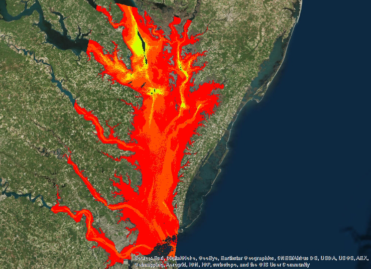
What are the major findings of your research?
We used a regression formula to correlate Landsat reflectances with MODIS Aqua chlorophyll measurements. Our major finding was that there is a relationship between certain Landsat bands and MODIS chlorophyll measurements, so it is possible to use Landsat bands to identify relative chlorophyll levels.
What insight did you gain from Landsat that would have been impossible to glean otherwise?
MODIS Aqua has 1 kilometer resolution. This is great in the ocean, but way too big for smaller water bodies like the York River. By correlating Landat and MODIS Aqua, we were able to visualize chlorophyll at Landsat’s 30 meter resolution. This scale was much more appropriate for our study area.
Were there challenges blending MODIS and Landsat data?
Yes, in deep water, there was a very strong correlation. But, the relationship wasn’t as strong in shallow water. We had to add bathymetry to our equations.
In what ways can your research help the Chesapeake Bay?
Our goal was to provide a tool to help the Virginia Institute of Marine Science and other agencies who track harmful algal blooms identify potential “hot spots” quickly and inexpensively, so they can better target their research efforts.
How was your experience with the NASA DEVELOP program?
I was with DEVELOP last summer. I really enjoyed being able to use what I am learning in school to solve real world problems. I’m not with DEVELOP now, but I’ve been working with Dr. Ross on a related research project to identify the spectral signature of Alexandrium monilatum, which is one of the species that the Virginia Institute of Marine Science is especially concerned about.
Co-author:
Cassandra Morgan
Anyone can freely download Landsat data from the USGS EarthExplorer or LandsatLook.
Further Reading:
+ Landsat at #AGU15


