

Presentation title:
Landsat Detection of the Effects of Hurricane Sandy on New Jersey Coastal Marshes
What are the major findings of your research?
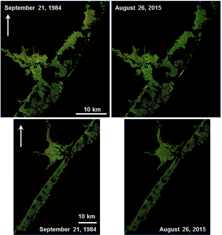
Our research suggests that the New Jersey Atlantic coastal marshes appear to be remarkably stable—although with considerable inter-annual variation in marsh area between 1984 and 2015. Hurricane Sandy may have had more beneficial effects than detrimental ones on the marshes; however, there are some serious limitations to our study. The spatial resolution of the two Landsat sensors used in the study is 30 meters. Sub-pixel resolution of any changes to marsh area are impossible due to the fluctuation in sea level caused by tides and waves; therefore Landsat cannot detect any change in marsh area less than 30 square meters. Also, there is a gap in data between the failure of Landsat Thematic Mapper in November of 2011 and the launch of the Landsat Operational Land Imager in early 2013*, so we do not have Landsat data sets from immediately before and after Hurricane Sandy which makes it difficult to attribute with confidence any changes in the marshes to Hurricane Sandy.
The most important finding therefore of our research is that the storm surge caused by Hurricane Sandy, while the largest in recent memory, caused very little damage that can be attributed uniquely to Sandy. Preliminary results suggest that there was more marsh loss between 1984 and 1995 than any damage caused by Hurricane Sandy, or that the marshes recovered between Sandy and the first Landsat 8 data set after Sandy in 2013. Fish and Wildlife personnel working on the Edwin B. Forsythe National Wildlife Refuge marshes stated that they saw remarkably little evidence of Hurricane Sandy-induced damage, so our preliminary results may be accurate.
What insight did you gain from Landsat that would have been impossible to glean otherwise?
Landsat has two great strengths. The first, which is unique to Landsat compared to other remote sensing sensors, is that the Landsat archive of 30 m spatial resolution data dates back to 1984. This allows researchers to evaluate contemporary events in the context of historical changes that occurred over a period of several decades. The second advantage of Landsat and other remote sensing sensors is that large areas of the Earth’s surface can be analyzed simultaneously and repeatedly over time in a cost effective way. These observations are typically not available by any other means.
Do you foresee that your research will encourage any marsh or barrier island restoration or protection projects along the New Jersey or New York coast?
This is by far the most difficult question to answer. Our results to date are still preliminary, but assuming our final analysis supports the preliminary results, we would conclude that the marshes served their designed purpose of protecting inland areas and as such are worth protecting. It is also clear, that the barrier islands—that are the first line of defense of the coast—did sustain serious hurricane damage. However, the coupled barrier island/coastal marsh system appears to have functioned as nature designed. But that may not be much consolation to the inhabitants of the cities and towns located on the barrier islands that lost their homes.
Co-authors:
Michael Kearney
University of Maryland College Park
Yu Mo
University of Maryland College Park
*Editor’s note: Landsat 7 was collecting data during this period (2011–2013), however about 25% of each scene’s data is missing because of a 2003 hardware component failure that leaves wedge-shaped spaces of missing data on either side of Landsat 7’s images.
Anyone can freely download Landsat data from the USGS EarthExplorer or LandsatLook.
Further Reading:
+ Landsat at #AGU15


