Changing Precipitation Patterns Impacting Tibetan Plateau Glaciers

Changing Precipitation Patterns Impacting Tibetan Plateau Glaciers

Precipitation patterns of Tibetan Plateau
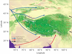
Glacier concentrations on the Tibetan Plateau are found where the Indian Monsoons (red) and westerlies (blue) exert the most influence. Credit: Yao et al.
In the July issue of Nature Climate Change, Tandong Yao and colleagues report on the changing status of Tibetan Plateau glaciers over the past three decades. Using an array of data sources including Landsat (MSS, TM, and ETM+), the researchers studied the surface area changes of over 7,000 glaciers. They found an overall reduction of 1200 square kilometers over thirty years (approximately the area of Los Angeles).
Glacier location and size on the Tibetan Plateau is a function of the region’s massive topographic landforms combined with precipitation patterns of the summer Indian monsoon (on plateau’s Southern/SE flanks), winter westerlies (along plateau’s SW and NW flanks), and the East Asian monsoon patterns to the East. Yao and colleagues saw the most dramatic glacier shrinkage in the southeastern part of the Tibetan Plateau where glacier length decreased on average 48 square meters per year. Glaciers shrank the least in the northwestern reaches of the Tibetan Plateau, in the Pamir region. The authors contribute the varying glacier statuses to changing precipitation levels from the weakening Indian Monsoon (decreasing precipitation) and strengthening westerlies (increasing precipitation).
Changing glacier size could impact water supply of the many rivers fed by the glaciers. These rivers are important sources of water and power in the region and can impact the livelihoods of over a billion people.
Reference:
+ Tandong Yao, Lonnie Thompson, Wei Yang, Wusheng Yu, Yang Gao, Xuejun Guo, Xiaoxin Yang, Keqin Duan, Huabiao Zhao, Baiqing Xu, Jiancheng Pu, Anxin Lu, Yang Xiang, Dambaru B. Kattel & Daniel Joswiak (2012). Different glacier status with atmospheric circulations in Tibetan Plateau and surroundingsNature Climate Change, 15 July 2012, doi:10.1038/nclimate1580.

Get the latest from Landsat in your inbox.


By submitting this form, you are consenting to receive marketing emails from: Landsat Science. You can revoke your consent to receive emails at any time by using the SafeUnsubscribe® link, found at the bottom of every email. Emails are serviced by Constant Contact
On Key

Recent Posts

Map shows South Korea with waterways highlighted. In the top right corner is a north arrow and in the bottom left corner is a legend of different rivers in South Korea.

Monitoring Water Quality in South Korea

South Korea is facing a water quality problem. Researchers Hyunglok Kim and Seongjun Lee from the Gwangju Institute of Science and Technology (GIST) embarked on developing a model to predict water quality indicators in near real-time.

Read More »
Landsat outreach specialist Allison Nussbaum and GEDI/UMD Faculty Specialist Talia Schwelling hold Landsat/GEDI postcards at the NASA exhibit booth at AGU24.

Landsat at AGU24

The NASA Landsat Science and Outreach teams attended the American Geophysical Union’s annual meeting in DC in December. At AGU24, they shared research and educated the public about Landsat.

Read More »
On Key

Related Posts

Map shows South Korea with waterways highlighted. In the top right corner is a north arrow and in the bottom left corner is a legend of different rivers in South Korea.

Monitoring Water Quality in South Korea

South Korea is facing a water quality problem. Researchers Hyunglok Kim and Seongjun Lee from the Gwangju Institute of Science and Technology (GIST) embarked on developing a model to predict water quality indicators in near real-time.

Read More »
Landsat outreach specialist Allison Nussbaum and GEDI/UMD Faculty Specialist Talia Schwelling hold Landsat/GEDI postcards at the NASA exhibit booth at AGU24.

Landsat at AGU24

The NASA Landsat Science and Outreach teams attended the American Geophysical Union’s annual meeting in DC in December. At AGU24, they shared research and educated the public about Landsat.

Read More »