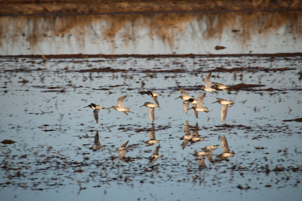
Migratory birds can fly thousands of miles as they move north in the spring and south in the fall on their yearly migrations. In an effort to restore lost natural wetlands they use on their journey, NASA Earth observations and citizen science are informing a program called BirdReturns, a project launched by The Nature Conservancy in California that pays rice farmers to keep their fields flooded for a few extra weeks to create over 60,000 acres of “pop-up” habitat for migratory birds since 2014.
“The fall shorebird migration season, which extends from July through October, is when there is the greatest deficit of habitat,” said Rodd Kelsey, associate director of The Nature Conservancy’s water program. “So we’re using NASA Earth observations and eBird network data to pinpoint exactly where habitat is needed most.”
Davis Ranches, a 5,000 acre rice farm in Northern California, has been participating in the BirdReturns program since it began. “We’d been working with conservation efforts for a decade,” said John Brennan, a manager at Davis Ranches. “The BirdReturns program is mutually beneficial for the rice industry – it helps us integrate ecological benefits into the process of growing food for the country.”
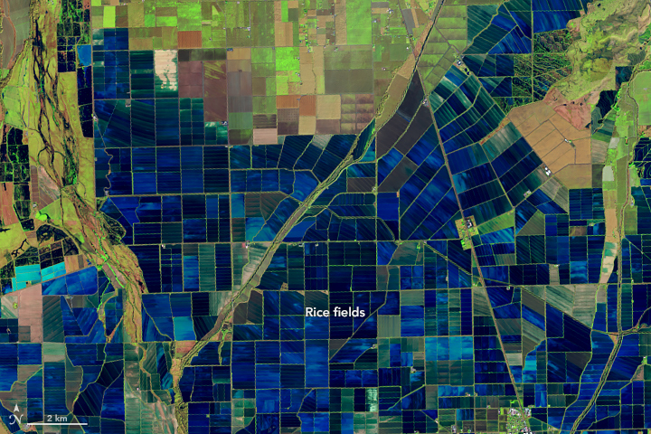
The effort took a team of collaborators, incorporating expertise from the Cornell Lab of Ornithology, who developed an app called eBird. The app enables citizen scientists and amateur birdwatchers alike to instantly upload information on birds they’re seeing. They are now combining those data with habitat information from NASA Landsat and MODIS satellite instruments, working with Point Blue Conservation Science to develop a model to predict where the birds are going – and where the birds need this pop-up habitat the most. Landsat is a joint program between NASA and the U.S. Geological Survey, and MODIS, which stands for Moderate Resolution Imaging Spectroradiometer, can be found on NASA’s Terra and Aqua satellites.
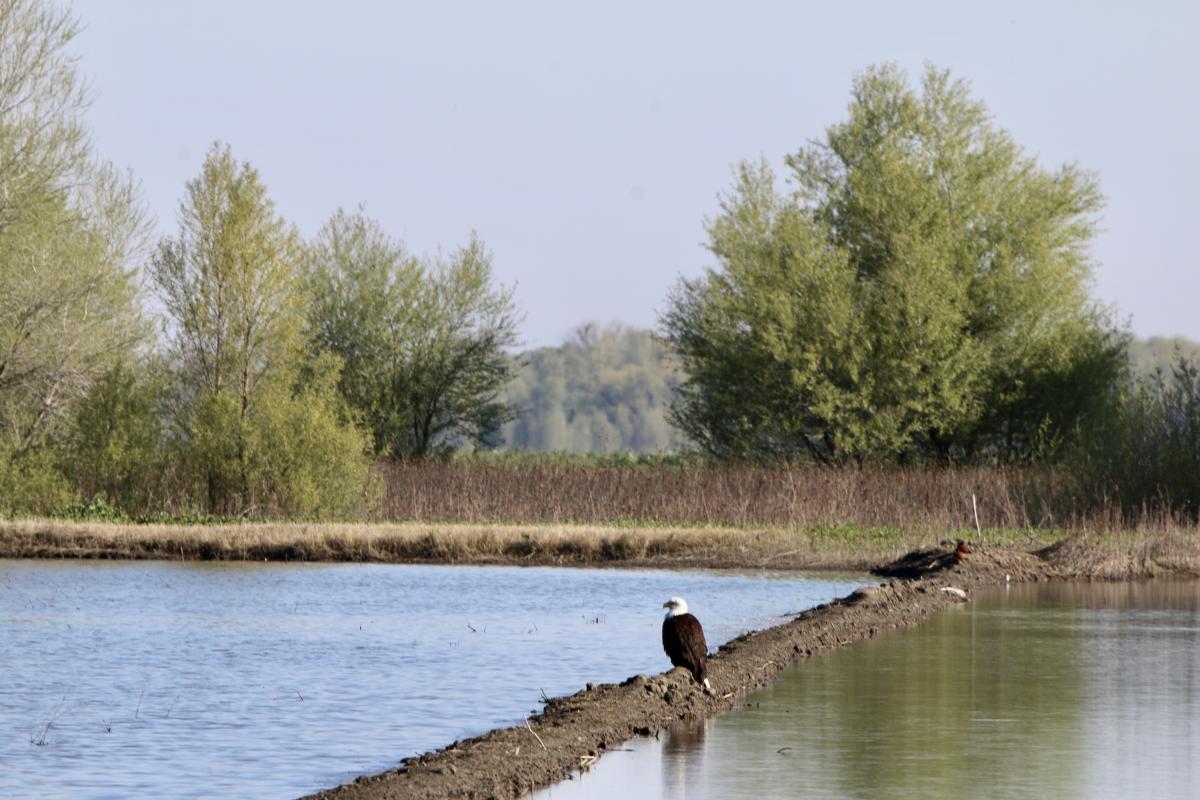
The project started with The Nature Conservancy, where Mark Reynolds works as a senior scientist. Historically, most Nature Conservancy projects involved purchasing land in order to protect and restore habitats vital to imperiled species and ecosystem health. But, buying all the land necessary to protect biodiversity is expensive and many animals do not stay in one place – migratory birds can travel for thousands of miles, crossing property lines and national borders – and don’t need habitat in the same place all of the time. To protect these birds, the Conservancy needed a solution flexible enough to create “pop-up” habitats just when and where the birds need them most. For migrating water birds, these are areas of land with enough standing water to be suitable for many types of birds to use as they migrate through or spend the winter.
Migratory birds travel between summer and winter homes as far apart as the Arctic and the Patagonia region of South America, millions flying through California on their way. Rice farmers in California regularly flood their fields to break down remnants from the last harvest – temporarily creating ideal conditions for the birds to rest and refuel. “Our mission at the Nature Conservancy is to conserve the lands and waters on which all life depends,” Reynolds said. “But we can’t buy and conserve everything – we needed to figure out how we could provide dynamic protection to birds.”
The Nature Conservancy now pays some farmers to keep their land flooded earlier and longer to match up with the birds’ flight plans. The partnership was new, but natural, Reynolds said.
“We combined big data analytics with citizen science to create a ‘habitat market’ – a novel concept in conservation,” Reynolds said. The farmers who are interested in participating submit bids for how much they’d charge The Nature Conservancy to keep their lands flooded for additional time. “It’s a way for everyone to gain value from the partnership.”
“Thanks to the team effort, it’s more successful than we even hoped,” Reynolds said. “The farmers are happy to participate and the shorebirds are happy to use their land.”
Supported by a grant from Earth Applied Sciences Program’s Ecological Forecasting program area, what began as a pilot program across 40 farms in 2014, has since resulted in nine seasonal habitat markets, working with over 100 farmers to create over 60,000 acres of seasonal habitat. Most recently The Nature Conservancy has worked with the California Rice Commission to create 1,200 acres of suitable habitat for 2020’s fall migration. More than a million birds representing over 60 wetland-dependent species of bird have used this pop-up highway since the project began, with thousands more this year.
Next, the team expects to use this concept for other conservation purposes, as well. Kelsey said the success of this project shows how valuable it could be if expanded. “We’ve demonstrated a proof of concept, but we need hundreds of thousands more acres – so now, we need to scale, Kelsey said. “We’re crowdsourcing the model, using NASA Earth observations and eBird network data to pinpoint exactly w
here the return on this investment will be greatest and transferring responsibility for running these auctions to the stakeholders themselves.”
Kelsey says that one of the next promising areas for a BirdReturns marketplace is the San Joaquin Valley of California, where intensive farming has overdrafted groundwater supplies to the point that the land is actually sinking. “We’re demonstrating how much groundwater recharge you can get by flooding farm fields to create habitat for migratory birds and we are hopeful that the BirdReturns program can play an important role incentivizing farmers over large areas.”
For farmers, bird enthusiasts and conservationists alike, that’s more good news on the horizon. For now, millions of shorebirds can rest a little easier as they travel each season.