By Laura E. P. Rocchio

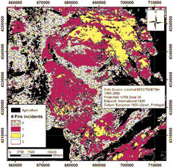
A group of European researchers have used Landsat data collected over a quarter of a century to evaluate fire management methods in Eastern Spain. Just 40 miles southwest of the Spanish city of Valencia, the Ayora region covers nearly half a million acres of countryside; here, Achim Röder and his team of researchers used Landsat data to study the driving factors of fires in European Mediterranean countries—where fire frequency has recently been on the rise.
While fires are a natural process in many Mediterranean ecosystems, human death tolls, structure losses, soil sterilization and erosion have made fire prevention an attractive management goal. Since the massive Ayora fire in 1979, regional ecological managers have implemented a wide range of fire prevention techniques.
Using Landsat to analyzing fire extents and post-fire vegetation regrowth, Röder and his team provided local land managers with information necessary to evaluate their fire prevention techniques. This evaluation led to the conclusion that past prevention techniques have been largely unsuccessful. Research-based suggestions to improve fire prevention success included: (1) increasing landscape fragmentation, and (2) reducing dry fuel loads by either mechanical removal, controlled grazing, and/or introduction of woody tree species able to survive fires (known as resprouters).
This research shows the potential for formulating successful ecosystem-specific wildfire mitigation strategies using Landsat time-series data in conjunction with plant succession patterns.
Reference
Röder, A., J. Hill, B. Duguy, J.A. Alloza, and R. Vallejo (2008). Using long time series of Landsat data to monitor fire events and post-fire dynamics and identify driving factors. A case study in the Ayora region (eastern Spain). Remote Sensing of Environment, vol. 112, no. 1, pp.: 259–273.


