
Presentation Title
Analysis of optical imagery reveals regionally coherent slowdown in High Mountain Asia in response to glacier thinning
What are the major findings of this research?
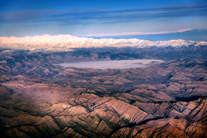
We are interested in glaciers response to present climate change, in particular how ice flow evolved over the last decades. This is an important feature as it drives the redistribution of ice down-valley and the glacier geometry, therefore the glacier sensitivity to climate. In this project, we observe annual ice flow surface velocity from a series of Landsat images using feature-tracking methods. The difference with most previous studies is that we process every possible image pair (up to 240,000 pairs for one UTM zone) and aggregate them together in a single annual value. This enables a maximum coverage and a better quantification of the uncertainty and outliers rejection. Our end result is a series of annual velocity fields from 1988-2015 for the entire High Mountain Asia (approx. 110.000 km2 of glacierized area).
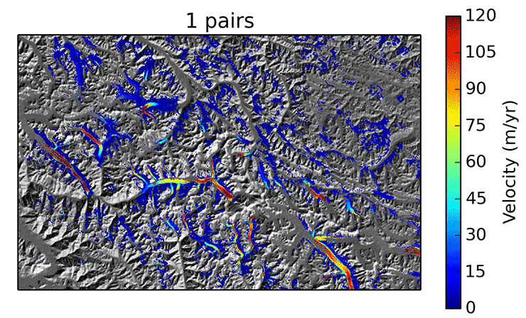
From these observations, we can derive trends in ice flow velocities over a few decades. Our main finding is that most glaciers in High Mountain Asia are slowing down over the period 1999-2015. The patterns of velocity change mirror very well the changes in glaciers thickness. Glaciers that are thinning are slowing down, whereas some stable/advancing glaciers over the last 15 years, located in the north-western ranges, show signs of acceleration. However, we show using glacier flow line models, that the change in velocity can likely not be fully explained by a change in driving stress, i.e a change in ice thickness and slope, observed for a similar period. Therefore, other processes such as changes in basal conditions, must be involved in order to explain the ice flow changes.
What are the implications of your findings?
First of all, this represents one of the first observations of glacier velocity and velocity changes at such a regional scale, obtained from a homogenous source (Landsat images). This will provide unprecedented insights into glacier dynamics and response to climate changes. Such data can be used in glacier models to estimate their volume, their contribution to the hydrological system and their future evolution. This might also help constraining changes in air temperature and precipitations in the remote mountainous areas.
Furthermore, we show that velocity is a relatively good proxy for a glacier state (mass gain or loss). Velocity could therefore be our best clue for glacier changes for earlier periods or certain areas where no observation of volume or mass change exist. Feature-tracking is indeed less restrictive than other methods for volume/mass changes observations.
What insight did you gain from Landsat that would have been impossible to glean otherwise?
When we started this project, we decided to focus on Landsat images without much hesitation for several reasons. First of all, it is the longest freely available satellite archive and it allows us to look back in time further than with any other data set. Unfortunately, the quality of the earlier missions with a coarser resolution was not sufficient for our project, but the data are still of valuable value for other areas and we were still able to obtain observation from as early as 1982 (Landsat 4). And the quality of the Landsat 8 images is simply amazing! Secondly, the global coverage and repeat acquisitions are an undeniable advantage. One drawback of optical images is the presence of clouds or shadows, but thanks to our systematic processing and an image (almost) every 16 days, a few missing observations are not such a problem. We are really grateful to the USGS for providing the data freely and efficiently.
Do you have plans to continue monitoring High Mountain Asia glacier velocities into the future?
Yes, this project is just a start, the amount of data produced will probably be a source of discoveries for years to come. We need to understand the patterns of velocity changes that we observe, both in relation with regional climatic trends and at the local scale. In term of monitoring, there are several improvements that can still be made, in order to observe for example changes at sub-annual scales or to provide near real-time observations.

Co-authors:
Alex S Gardner
NASA Jet Propulsion Laboratory
Noel Gourmelen
University of Edinburgh
This research was made possible by the ESA – NRSCC Dragon project, CNES (the French space agency), and the Savoy region.
Anyone can freely download Landsat data from the USGS EarthExplorer or LandsatLook.
Further Reading:
+ Landsat Abounds at #AGU16

Be Part of What’s Next: Emerging Applications of Landsat at AGU24
Anyone making innovative use of Landsat data to meet societal needs today and during coming decades is encouraged to submit and abstract for the upcoming “Emerging Science Applications of Landsat” session at AGU24.


