Source: Michon Scott, NASA’s Goddard Space Flight Center

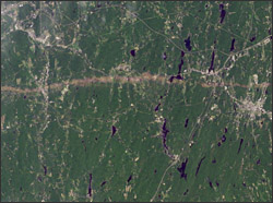
On June 1, 2011, a supercell thunderstorm developed over western Massachusetts. The storm produced an EF3 tornado that cut a 39-mile (63-kilometer) track of destruction across southwest and south-central Massachusetts. Not only did the long-lived tornado remain on the ground for many miles, but it also widened to 0.5 miles (0.8 kilometers).
The Thematic Mapper on the Landsat 5 satellite captured this natural-color image on June 5, 2011. This image shows part of the tornado track, including damage in Sturbridge. According to the Boston Globe, Massachusetts state police reported a tornado on the ground in Sturbridge at 5:22 p.m. The tornado was spotted on the Interstate 84 exit, and cars were overturned.
The Boston Globe reported that the Massachusetts governor declared a state of emergency and ordered National Guard troops to assist with cleanup efforts. Tornadoes on June 1 killed at least four residents of the state, as well as reducing homes, schools, and churches to rubble.
On June 8, 2011 the U.S. Army Corps of Engineers asked NASA for the full-resolution Landsat 5 image to help do first order assessments of the tornado damage to Federal properties in the state. The USACE has also conducted their own aerial surveys which will be used for more detailed assessments once that data is available. (The full resolution Landsat 5 image is available from Earth Observatory.)
Further Information:
+ Landsat 5 Satellite Sees Tornado Track near Sturbridge, Massachusetts
+ Earth Observatory Image of the Day
+ USGS Press Release

Be Part of What’s Next: Emerging Applications of Landsat at AGU24
Anyone making innovative use of Landsat data to meet societal needs today and during coming decades is encouraged to submit and abstract for the upcoming “Emerging Science Applications of Landsat” session at AGU24.


