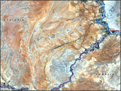
The uncertain political situation in Somalia has hampered relief efforts and sent thousands fleeing to border countries, such as Ethiopia.
In an effort to support the German Federal Agency for Technical Relief work on the ground, Germany’s space agency has created maps of the regions in Ethiopia where refugee camps have sprung up. The maps are based on Landsat 5 data and are supplemented with vector data from various sources.
Source: German Aerospace Center (DLR)
Further Information:
+ Famine in East Africa, Center for Satellite Based Crisis Information, DRL [external link]
+ UN: DLR/ZKI produces Geographic Reference Maps to Support Relief Response to the Famine in East Africa [external link]

Be Part of What’s Next: Emerging Applications of Landsat at AGU24
Anyone making innovative use of Landsat data to meet societal needs today and during coming decades is encouraged to submit and abstract for the upcoming “Emerging Science Applications of Landsat” session at AGU24.


