NASA’s Fire Information for Resource Management System (FIRMS) was developed in 2007 to provide near real-time active fire data to natural resource managers generally within three hours of satellite observation. Since its inception, the majority of these data have come from two instruments: the Moderate Resolution Imaging Spectroradiometer (MODIS) aboard NASA’s Terra and Aqua satellites, and the Visible Infrared Imaging Radiometer Suite (VIIRS) aboard the joint NASA-NOAA Suomi National Polar-orbiting Partnership (Suomi NPP) and NOAA-20 satellites.
The importance of MODIS and VIIRS to the detection and monitoring of wildland fire is due in large part to the frequency of their observations. The MODIS instruments aboard Terra and Aqua and the VIIRS instruments aboard Suomi NPP and NOAA-20 view the entirety of Earth’s surface every 1 to 2 days. These repeated and timely observations provide wildfire response teams and natural resource managers with a wealth of data they can use to detect new fires, track the growth of known fires in near real-time, and assess the impacts of large burns.
However, in the context of satellite remote sensing, there is an inverse relationship between temporal resolution (or revisit time) and spatial resolution; meaning that what is gained in temporal resolution is lost in spatial resolution, and vice versa. Neither MODIS nor VIIRS are exempt from this relationship. Therefore, although MODIS and VIIRS offer impressive temporal resolution, their spatial resolution—1 kilometer for MODIS and 375 meters for VIIRS—is considered rather coarse by most standards.
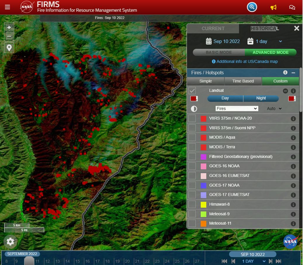
To address this trade-off, FIRMS recently added a new near real-time Landsat Fire and Thermal Anomalies (LFTA) product for continental U.S., the southern half of Canada, and the northern half of Mexico that offers high-resolution, 30-meter active fire detection data within 30 to 60 minutes of observation.
“Users value higher spatial resolution data. They really gravitated to the VIIRS 375-meter near real-time active fire data relative to MODIS because of its higher spatial fidelity, while still providing comprehensive coverage and multiple revisits on a daily basis,” said Brad Quayle, Remote Sensing and GIS specialist with the USDA Forest Service’s Geospatial Technology and Applications Center (GTAC). “Although Landsat does not provide the comprehensive daily coverage of MODIS or VIIRS, its spatial fidelity is a tremendous improvement and provides the ability to detect and more precisely locate fire activity, at least for the areas imaged on a given day.”
Dr. Morgan Crowley, Fire Research Scientist with Canadian Forest Service’s WildFireSat Mission, agrees and calls the addition of Landsat active fire data in FIRMS “exciting,” as it increases FIRMS’ utility to the fire science community.
“Landsat active fire hotspots provide fine spatial scale information that is useful for contextualizing sub-daily observations from the other products like MODIS, VIIRS, and Harmonized Landsat-Sentinel (HLS),” she said. “Additionally, there is now a greater opportunity to combine the fine spatial scale hotspots from Landsat with the fine temporal scale hotspots from the existing sources using one seamless pipeline when accessing data in FIRMS.”
The LFTA product is based on multispectral imagery acquired by the Operational Land Imagers (OLI) aboard the Landsat 8 and Landsat 9 satellites. The OLI’s 30-meter resolution provides active fire detection data with 1,000 and 160 times finer spatial resolution than MODIS and VIIRS, respectively, and its enhanced capabilities allow it to detect active fires as small as approximately four-square meters during the day. Nighttime detection of similar fire activity, when available, improves to an area as small as 1-square meter.
“The resolution of MODIS and VIIRS bands used for fire detection are relatively coarse and a fire detection can be triggered by a relatively small, intensely burning and isolated fire within the pixel or from a fire burning more broadly across the extent of the pixel,” Quayle said. “The spatial fidelity of Landsat active fire detection data and its use in the context of MODIS and VIIRS allow users to not only validate those coarser resolution detections, but more precisely locate fire activity, such as the smaller, isolated, but intense fires that cannot be reliably discerned from coarser resolution imagery and derived data.”
Such improvement in the ability to pinpoint ignitions is of significant benefit to fire managers.
“FIRMS is useful for active fire monitoring as it provides hotspot data in an easy-to-use platform in a rapid operational timeline,” Crowley said. “Having Landsat data now available means that fire managers will have access to more detailed hotspot points which could be useful for looking at fire lines, nighttime burning, and small-scale ignitions and fires.”
Further, the LFTA product’s low latency means that these Landsat data are available to users much sooner than the HLS data products provided through FIRMS, which require approximately two days of processing after acquisition.
“The LFTA product is currently provided for most of North America in near real-time, within 30 to 60 minutes after satellite overpass,” Quayle said. “Having these data available at this low latency thanks to the support of the NASA and USGS Earth Resources Observation and Science (EROS) Data Center greatly increases their value to the user community.”
With the OLI aboard both Landsat 8 and Landsat 9, approximately 15% of the continental U.S. is imaged on a daily basis. That may not sound like much, but Quayle says it is enough to provide somewhat significant coverage for strategic fire monitoring purposes.
“When it images ongoing incidents on a given day, the LFTA product is going to be a helpful resource,” he said.
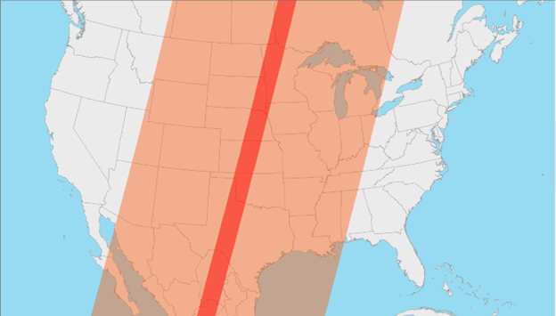
Quayle acknowledges that having Landsat active fire detection data captured at the temporal resolution and geospatial coverage provided by MODIS and VIIRS would be ideal. Landsat satellites do not provide such comprehensive global coverage on a daily basis because, unlike VIIRS and MODIS, OLI has a much narrower swath width of 185 kilometers, so it requires 16 days to completely image Earth’s surface. The relatively large swath widths of MODIS and VIIRS allow them to provide comprehensive satellite observations and acquire active fire detection data for the entire globe each day. So, OLI can only provide partial coverage of large geographic areas. However, since the orbits of the Landsat 8 ad 9 satellites are 8 days out of phase, the revisit time for a particular location is every 8 days. Users can determine the time and location of Landsat observations for a selected date by consulting the Landsat 8 and Landsat 9 orbit tracks on the FIRMS fire maps.

Quayle also noted that the temporal resolution of routine daytime Landsat observations may be improved by requesting that the USGS’s Earth Resources Observation and Science (EROS) Center arrange nighttime OLI imagery collections for targeted areas when it can feasibly be done within the confines of current Landsat science and mission priorities.
“This can potentially improve the temporal resolution of the Landsat active fire product to about four days for particular incidents,” Quayle said. “There is also the potential to use additional satellite sensors with spatial and spectral resolution similar to Landsat’s OLI, but relatively better temporal resolution. Use of the combined observations of Landsat OLI and these other sensors could reduce the temporal resolution to as little as 1-2 days.”
Expanding the extent of the operational NRT LFTA product, which, as noted earlier, is currently limited to the continental U.S., the southern half of Canada, and the northern half of Mexico, is more of a challenge.
“Currently, the extent of the operational near real-time product is limited to the area of Landsat direct broadcast data collection coverage provided by the Landsat Ground Station EROS, which is located in Sioux Falls, South Dakota,” Quayle said. “This covers all of the continental U.S., the southern half of Canada, and the northern half of Mexico. To expand near real-time Landsat active fire detection coverage to other areas of the globe will require investment of time and resources to implement similar operational data streams at other Landsat 8 and Landsat 9 ground stations.”
Nevertheless, the feasibility of including additional ground stations for North America and elsewhere is currently being investigated.
The LFTA product is collaboratively produced by NASA’s Land, Atmosphere Near real-time Capability for EOS (LANCE), the University of Maryland, the U.S. Forest Service, and EROS. It was created at the request of NASA and the U.S. Forest Service, who asked EROS to develop a near real-time data processing framework that provides Level 1 terrain-corrected Landsat OLI imagery, which is then processed further with NASA science data algorithms to generate the Level-2 30-meter resolution active fire data product. This methodology produces the data that are imported directly into FIRMS and negates the need for NASA and the U.S. Forest Service to download numerous scenes of Landsat data for subsequent staging and processing.
“We coordinated with the Landsat Team at EROS to discuss possibilities about the availability of low latency Landsat OLI imagery,” said Quayle. “They have been very accommodating to our request and developed an optimized near real-time processing stream to provide terrain corrected OLI imagery about 30 minutes after an overpass.”
Currently, the Landsat active fire data reach back to June 2022. Although the processing of earlier acquisitions by Landsat 8 and Landsat 9 is possible, Quayle said there are no plans to provide them in FIRMS at this time.
Users should be aware that the LFTA product lacks fire characterization information, such as estimates of a fire’s radiative power or heat energy, and that each hotspot/active fire detection represents the center of a 30-m pixel containing one or more fires or other thermal anomalies. Therefore, the location provided for each detection is the center point of the pixel and not necessarily the coordinates of the actual fire.
Despite these limitations and its 8-day revisit time, this low latency product gives operational fire managers and fire scientists quicker access to more precise, higher-resolution data.
“For active fire management purposes, the more timely the data, the greater its value. Yes, the temporal resolution is currently the greatest limitation, but until now, the bigger limitation in the operational use of the Landsat active fire data product was its latency—the availability of the source Landsat OLI imagery after satellite observation,” Quayle said. “Without the partnership and substantial contributions of EROS, the operational availability and potential value of this product would never be realized.”
About FIRMS
FIRMS was developed in 2007 by the University of Maryland, with funds from NASA’s Applied Sciences Program and the United Nations Food and Agriculture Organization (UN FAO), to provide near real-time active fire locations to natural resource managers that faced challenges obtaining timely satellite-derived fire information.
FIRMS US/Canada, which launched in January 2021, was developed through an agreement between the U.S. Forest Service’s GTAC and NASA to modernize and optimize the U.S. Forest Service’s distribution of active fire information by leveraging LANCE’s web-based active fire mapping tools and capabilities for disseminating data, products, and services.
Like the original FIRMS, FIRMS US/Canada provides active fire imagery that can be viewed on an interactive fire map and current and historical corrected reflectance imagery from NASA and NOAA satellites. It also meets recently developed U.S. Forest Service requirements by offering additional contextual layers and enhancements, including the depiction of active fire fronts complete with time-since-detection information, incident locations, ownership boundaries for current large fires in the U.S. and Canada, and National Weather Service fire weather forecasts and red flag warning areas.
For More Information
For information on how to view the LFTA product in FIRMS, see the post, “New Near Real-Time Product in FIRMS – Landsat Active Fire Data” on the FIRMS blog.
How to Use FIRMS Video Tutorial: This tutorial offers an introduction to the basic and advanced features of FIRMS. It provides instruction on how to view satellite observations of active fires and hotspots on an interactive map, navigate between the basic and advanced modes, and add imagery layers to see fires and smoke plumes.


