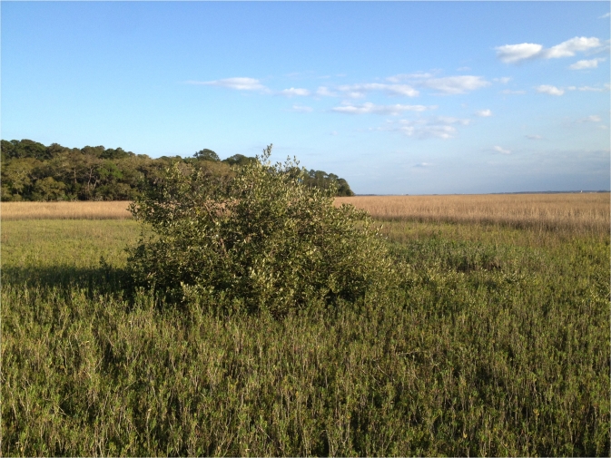
Image Credit: Courtesy of Kyle C. Cavanaugh
Between 1984 and 2011, the Florida Atlantic coast from the Miami area northward gained more than 3,000 acres (1,240 hectares) of mangroves. All the increase occurred north of Palm Beach County. Between Cape Canaveral National Seashore and Saint Augustine, mangroves doubled in area.
Meanwhile between the study’s first five years and its last five years, the northern limit of the mangrove forests, near Daytona Beach, recorded 1.4 fewer days per year when temperatures fell below 28.4 degrees Fahrenheit (-4 degrees Celsius). The number of killing frosts approximately 200 miles south, in southern Florida, was unchanged.
The research, funded by the NASA Climate and Biological Response Program and the National Science Foundation, was conducted by scientists from the University of Maryland, College Park, Md., and the Smithsonian Environmental Research Center, Edgewater, Md. The study was published online Dec. 30 in Proceedings of the National Academy of Sciences.
The expansion of mangrove forests along the coast is a striking example of an impact of climate change. A reduction in the frequency of extreme cold events appears to be driving this dramatic change in the land cover of the northeast Florida coast.
Unlike studies that focus on changes in average temperatures, this study shows that changes in the frequency of rare, severe events can determine whether landscapes hold their ground or are transformed by climate change.
The mangrove forests are edging out salt marshes, said University of Maryland Entomology professor Daniel S. Gruner, a study co-author. “This is what we would expect to see happening with climate change, one ecosystem replacing another. But at this point we don’t have enough information to predict what the long term consequences will be,” said Gruner, who co-leads an interdisciplinary research project on mangrove ecosystems, along with Ilka C. Feller of the Smithsonian.
“Some people may say this is a good thing, because of the tremendous threats that mangroves face,” said the study’s lead author, Kyle Cavanaugh, a Smithsonian postdoctoral research fellow. “But this is not taking place in a vacuum. The mangroves are replacing salt marshes, which have important ecosystem functions and food webs of their own.”
Mangrove forests grow in calm, shallow coastal waters throughout the tropics. Salt marshes fill that niche in temperate zones. Both provide crucial habitat for wildlife, including endangered species and commercially valuable fish and shellfish. Some animals use both types of habitat. Others, like marsh-nesting seaside sparrows or the honeybees that produce mangrove honey, rely on one or the other.
Both provide valuable ecosystem services, buffering floods, storing atmospheric carbon and building soils. Both are in decline nationally and globally. Mangrove forests are cut down for charcoal production, aquaculture and urbanization or lose habitat to drainage projects. Salt marshes are threatened by drainage, polluted runoff and rising sea levels.
Florida naturalists noticed that mangroves now grow in places that once were too chilly for the tropical trees. “We knew this was happening, but no one knew if it was a local or a regional phenomenon,” Cavanaugh said.
Cavanaugh, an expert in remote sensing, turned to images of Florida’s Atlantic coast taken by the NASA-USGS Landsat 5 satellite, which launched in 1984 and tracked changes in Earth’s land cover until 2011. “It very quickly became a gold standard to examine the effects of climate change, because it lets you look back in time,” Cavanaugh said.
The satellite images revealed the mangroves’ expansion into terrain formerly dominated by salt marsh plants. While the study only looked at the Atlantic Coast, the same trend is taking place on Florida’s Gulf Coast, Cavanaugh and Gruner said.
Mean winter temperatures have risen at seven of eight coastal weather stations in the study area. But if overall warming benefited mangroves, the mangrove cover should have increased all over Florida, not only in the north. Average winter temperature, rainfall, and urban or agricultural land use did not explain the mangroves’ expansion. Only fewer freezing days at the northern end of their range matched the trend.
Source: Heather Dewar University of Maryland
Read More at:
+ Landsat Satellite Sees Florida Mangroves Migrate North

Be Part of What’s Next: Emerging Applications of Landsat at AGU24
Anyone making innovative use of Landsat data to meet societal needs today and during coming decades is encouraged to submit and abstract for the upcoming “Emerging Science Applications of Landsat” session at AGU24.


