
By Laura E.P. Rocchio
This morning at #AGU16, Matthew Macander, a geographer specializing in wildlife, vegetation and habitat studies, gave a talk about patterns of snowmelt in the Arctic. Here’s what he shared with us:
Presentation Title
Snow depth and snow persistence patterns in the Arctic from analysis of the entire Landsat archive
What are the major findings of this research?
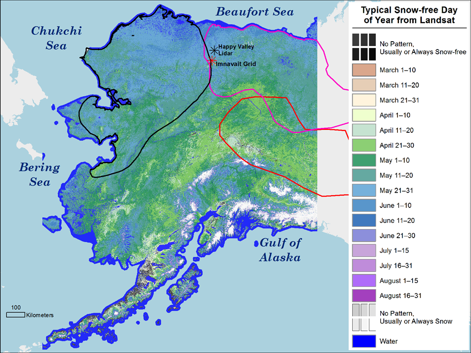
The extensive Landsat record can be analyzed to map the climatalogical normal date of snowmelt for large areas (such as the state of Alaska) at 30 m resolution. This provides the resolution necessary to resolve many snow patterns in mountains, tundra, and lake-rich areas that are obscured in coarser snow mapping products.
What are the implications of your findings?
Snow persistence has important direct implications for applications in including wildlife habitat availability and headwater hydrology. We show that it can also be related to snow depth, which has been challenging to model in heterogeneous landscapes.
What insight did you gain from Landsat that would have been impossible to glean otherwise?
There are potentially hundreds of observations of the snow status for any given 30 m patch in Alaska. There’s no other data source that can provide that.
Roughly how many Landsat scenes were part of your analysis?
We used Google Earth Engine to automate the snow mapping for every scene over Alaska from 1999–2015. So we never had to handle the scenes individually. I’d estimate it was about 100,000.
Co-authors:
Christopher S Swingley
ABR, Inc.—Environmental Research & Services
Charles Parr
University of Alaska Fairbanks
Matthew Sturm
University of Alaska Fairbanks
David Selkowitz
USGS Alaska Science Center
Chris Larsen
Geophysical Institute
Anyone can freely download Landsat data from the USGS EarthExplorer or LandsatLook.
Further Reading:
+ Landsat Abounds at #AGU16


