Dr. Stan Freden played a major role in the nascent Landsat program as the project scientist for Landsats 1, 2, and 3. As project scientist, he was responsible for evaluating the performance of the Multispectral Scanner System (MSS) instrument aboard each of the satellites, evaluating the quality of the MSS data, and coordinating the research of 300 scientific investigators! The scientific investigators came from universities, federal and state agencies, and private industry as well as about 100 foreign organizations.
Today, 34 years after his first encounter with Landsat, Freden still believes, “that Landsat-type data are a crucial requirement for understanding our planet and monitoring its metamorphosis.”
So, how did a nuclear physicist from California end up across the nation at NASA’s Goddard Space Flight Center in Maryland working on the first civilian Earth observing satellite program?
Beginnings
Freden was born on Long Island in New York. In 1941, he and his family moved across the country to Long Beach, California where he finished high school.
After high school, Freden spent 18 months in the U.S. Navy. In 1947, he enrolled at the University of California Los Angeles (UCLA) where he majored in physics and minored in mathematics.
Freden continued on to graduate school at UCLA, earning both a Masters degree and PhD in physics. He completed his doctorate work in 1956 and was the graduating class valedictorian that year.
Following his graduation, Freden did a short stint as an instructor at UCLA teaching physics to pre-med students. He then joined the Lawrence Livermore Laboratory (then known as the Lawrence Radiation Lab) where he worked on basic physics research and nuclear device diagnostics.
It was during this time, that Freden and a colleague were invited to fly a small experiment on a U.S. Air Force rocket. They flew a small (only an inch and a quarter square) photographic emulsion package on the rocket. With this emulsion package they discovered high-energy protons and heavier particles trapped in Earth’s radiation belt.
“We had our 15 minutes of fame!” Freden comments.
From Livermore, he went on to spend seven years with the Aerospace Corporation in Los Angeles where he supported Air Force satellite and space programs and continued his space physics research.
Then in 1968, Freden joined NASA as the chief of the Space Physics Division at the Manned Spacecraft Center in Texas, now called Johnson Space Center (JSC). During this period he lead research efforts on solar flares, cosmic rays, and micrometeorites. His group also supported the Apollo Lunar missions by monitoring the Sun for solar flares during Apollo moon landings.
“I was in the Mission Control Center when Apollo 11 landed on the moon,” Freden recalls.
After two exciting years in Texas, Freden took a job at NASA’s Goddard Space Flight Center in Greenbelt, Maryland as the Assistant Director of the Atmospheric Sciences Laboratory. There, he worked under the man who would introduce him to Landsat: William Nordberg.
The challenges of working with Landsat
Under Nordberg, Freden began to examine the ways in which Earth’s atmosphere could interfere with a satellite’s space-based view of Earth’s landmass. He studied the affects that atmospheric scattering and attenuation would have on satellite imagery. Atmospheric physics was not one of Freden’s original areas of specialization, so he had a bit of a learning curve when he got to Goddard.
As he explains, “although the laws of physics are universal, their applications are specific. So I had to learn.”
In 1972, when Freden became the Landsat project scientist for Landsat 1–then known as the Earth Resources Technology Satellite-1 (ERTS-1)–he again had to assume a new role and acquire the needed knowledge base that went along with the job.
When Landsat 1 was launched, the idea of observing Earth from space for civilian purposes was brand new, so as Landsat project scientist, Freden had to help potential Landsat data users understand the possible applications of Landsat data. Because Landsat imagery could be used by so many different disciplines (like geology, agriculture, and cartography), Freden had to learn about many aspects of Earth science.
But he was motivated to face this challenge; as he recounts, “the entire program was exciting to me. I felt that the Landsats 1, 2, 3 would be used to help monitor and understand the Earth’s environment and measure and manage its resources. That very concept was mind boggling at the time.”
Using Landsat data for environmental monitoring was a foreign concept in 1972; it meant that the techniques scientists had used to conduct monitoring before had to be augmented or modified. Such change is always hard and the introduction of new technology is often met with skepticism.
To help successfully promote the use of Landsat data, 300 scientists from various disciplines and organizations were invited to be Landsat principal investigators (PIs). The PIs were responsible for evaluating the usefulness of Landsat data within their fields of study.
“The transfer of the technology was clearly the most challenging aspect of the program for me,” Freden recalls.
In response to this challenge, he explains, “I organized and conducted four symposia, asking the PIs to present their findings so that all could see what results others were getting.”
According to Freden, the Landsat PIs helped to demonstrate the utility of Landsat data to many disciplines, including (1) geology–for the identification of surface features used for oil exploration, (2) surface water and flood plain mapping, (3) monitoring deforestation in the Amazon rain forest, and (4) cartographic monitoring–“many areas of the world, including the U.S., had either no maps or outdated ones and Landsat data provided useful maps in those locations.”
The rewards of working with Landsat

As Freden looks back on his long career, he can recall many personally rewarding moments from his pre-Landsat work. Yet he says working with Landsat was the most enjoyable part of his career.
“As Landsat Project Scientist, the challenges and the rewards were different. It was science and applications together. And the applications are not esoteric, but important to our future and that of future generations. That is what made it really interesting and exciting. I met and interacted with many interesting people and helped expedite the transfer of the technology to agencies, industry and universities in the U.S. as well as to many foreign countries. What could be more rewarding?”
Contributor: Laura Rocchio
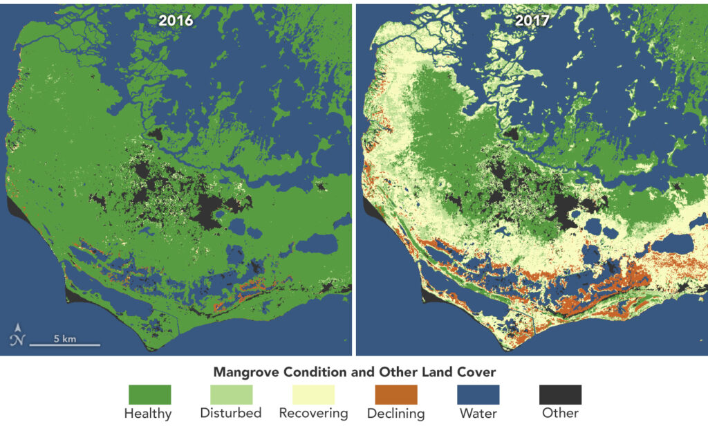
Mangroves Are Losing Their Resilience
Mangroves, the iconic trees and shrubs of the Florida Everglades, are under increased stress due to more frequent, intense hurricanes.