
We recently spoke with Dr. Tinder about this work:
In your recent article, you state that “The primary archive available for reviewing the positions of coastlines and effects of sea-level rise is Landsat.” Can you elaborate in what capacity and where geographically you have used the Landsat archive for coastline monitoring?
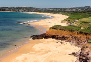
We are using Landsat time-series from year 1976 till the end of 2015 which include Landsat 5, 7 and 8. Geographically, the experimental data covers the Narrabeen-Collaroy beach which is a northern beach in Sydney about 15 km north of the CBD [Central Business District].
This beach has been studied by the engineers in The School of Civil and Environmental Engineering for about 40 years. We are currently comparing the extracted information for Landsat images with the details from field surveys.
Are there any other examples of groups using Landsat for coastline mapping that you are familiar with / consider significant?
We believe so far Geoscience Australia has been using Landsat for coastline mapping. Besides, there are some other papers which may indicate some groups are using Landsat time-series data for shoreline monitoring, for example:
‘‘Almonacid-Caballer J, Sánchez-García E, Pardo-Pascual J E, et al. Evaluation of annual mean shoreline position deduced from Landsat imagery as a mid-term coastal evolution indicator[J]. Marine Geology, 2016, 372: 79-88.’’
‘‘Maiti S, Bhattacharya A K. Shoreline change analysis and its application to prediction: a remote sensing and statistics based approach[J]. Marine Geology, 2009, 257(1): 11-23.’’
The first paper also extracts subpixel precision shorelines, which is exactly what we are doing but with different study site and different methodologies.
How would you describe the importance of the Landsat archive?
We think Landsat archive is very important considering the both long-time data acquisition and relatively high temporal resolution. It is indeed the best source of data available.

Be Part of What’s Next: Emerging Applications of Landsat at AGU24
Anyone making innovative use of Landsat data to meet societal needs today and during coming decades is encouraged to submit and abstract for the upcoming “Emerging Science Applications of Landsat” session at AGU24.


