
Source: Josh Blumenfeld, NASA Earthdata
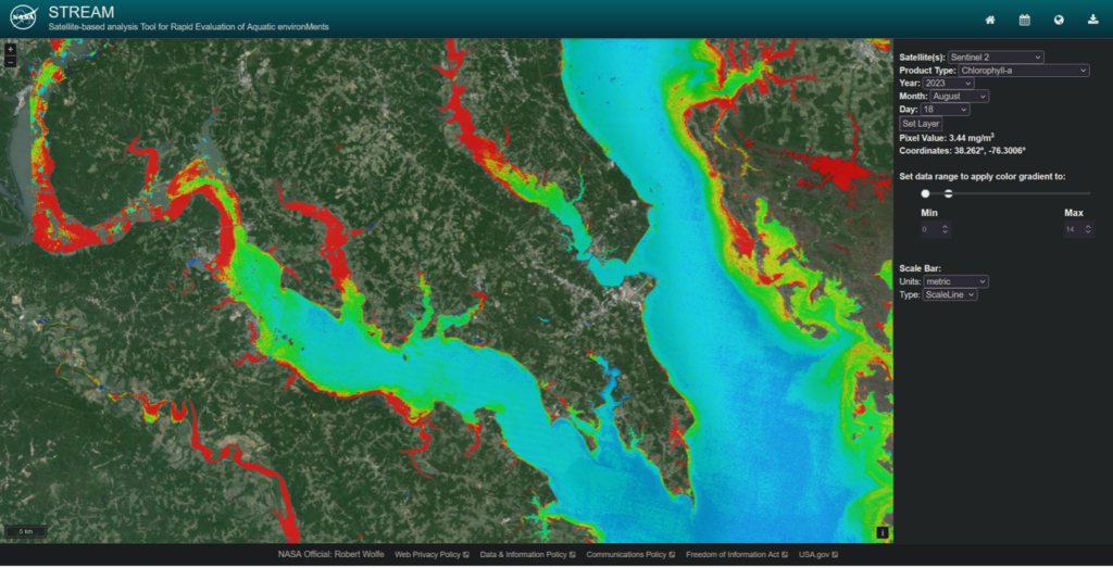
A new data processing tool that rapidly ingests, processes, and displays water quality maps generated from the Landsat 8 and 9 Operational Land Imager (OLI) and the European Union Copernicus Sentinel-2 Multispectral Instrument (MSI) at 20 to 30 meter resolution is now publicly available. The NASA-funded Satellite-based Analysis Tool for Rapid Evaluation of Aquatic Environments (STREAM) was developed jointly by scientists with the Freshwater Sensing Program of Science Systems and Applications, Inc. (SSAI) and NASA’s Goddard Space Flight Center in Greenbelt, Maryland, and offers globally validated water quality products created using a processing engine that leverages a machine-learning model.
STREAM provides the ability to visualize water quality maps, identify pixel values, and view time-series plots for a given pixel or region to enable low-latency (less than six hours) detection of anomalous water quality conditions. Through the STREAM interface, users can access water quality maps showing concentrations of chlorophyll-a, measurements of Secchi disk depth (water transparency), and assessments of total suspended solids (TSS).
Satellite images come from the USGS Landsat Project and the European Union Copernicus Open Access Hub, and are processed into water-quality maps using two independent streams of machine-learning models. The system also utilizes tools and capabilities developed as part of NASA’s near real-time data processing systems, particularly the Fire Information for Resource Management System (FIRMS).
Building a Better Water Quality Analysis Tool
STREAM was developed to help improve decision-making for coastal and lake resources, especially in the economically important areas of fisheries, aquaculture, and recreation. The tool grew out of a 2017 water quality workshop held at NASA Goddard. The workshop brought together almost 350 environmental specialists, economists, scientists, industry representatives, and legal advisors to discuss the concept and potential use of a satellite-based, near real-time water quality monitoring tool.
The tool was beta-tested with users in Peru, Uruguay, and the continental United States. The phased public release of STREAM 1.0 includes water quality maps for visualization and download with a geographic scope of selected regions in the continental U.S. (data from 2024 plus forward near real-time processing) and Peru, Uruguay, Uganda, Tanzania, Kenya, Ghana, Benin, and Senegal (data from 2014 to 2023 plus forward near real-time processing).
STREAM 2.0, currently in development, will expand the system to global coverage, provide image processing back to 2013, and add services including a user forum. The development team also plans to add additional data from NASA’s Plankton, Aerosol, Cloud, ocean Ecosystem (PACE) and Surface Biology and Geology (SBG) missions; the joint NASA/USGS Landsat Next mission; and the European Union Copernicus Sentinel-3 mission.
The SSAI Freshwater Sensing Program was created to provide consistent, reliable, and advanced global water-relevant products from satellite observations; enable sustainable use of aquatic ecosystems and their services; and work with NASA and international mission science teams to develop new capabilities. The program is funded by various NASA Research Opportunities in Space and Earth Sciences (ROSES) elements and received support from the USGS Landsat Science Team (2018 to 2023).
Additional resources
+ STREAM tool


