Contributor: Scott Goetz
After years of scientific research, policy analysis, public education, and substantial sums of money spent, restoration of Chesapeake Bay remains a challenge. Few of the indicators of habitat, fisheries, or water quality show significant improvement, and several show continued decline. Why is it so difficult to restore this national treasure?
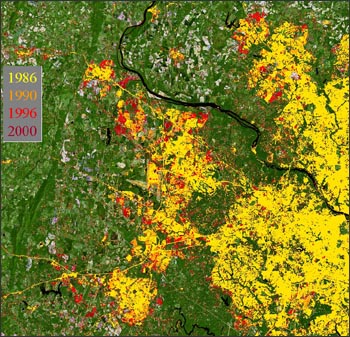
People desire to live on or near the water – and therein lies the problem. According to recent Landsat satellite analyses by researchers at the University of Maryland’s Mid-Atlantic Regional Earth Science Applications Center (RESAC), urban and residential lands surrounding the Bay have increased by 63 percent in the 15 year period 1986–2000 (see figure below).
Using a predictive model calibrated with the Landsat analysis, and assuming current trends continue, the group estimates an additional 80 percent expansion will occur by the year 2030. Changes of this magnitude increase the amount of nutrients and other chemical pollutants entering the Bay’s waterways.
The sensor on the Landsat satellite permits mapping of these built areas if sufficient information on the ground is available to “train” the mapping tools. The new maps can distinguish low-density from high-density residential development and crop land from pasture land, as well as from wetlands and different types of forest.

Landsat shows landscape scale change graphically and dramatically. Researchers express being continually impressed by the amount of land being consumed by new development. The Landsat perspective educates others as well. Already the RESAC Landsat-based maps are informing decision making at the local, state and federal levels, and have become incorporated into models that guide the Chesapeake restoration effort.
To learn more about the use of remote sensing for restoration and mapping of the Chesapeake Bay, visit the Chesapeake Bay Program (external link)website.

Be Part of What’s Next: Emerging Applications of Landsat at AGU24
Anyone making innovative use of Landsat data to meet societal needs today and during coming decades is encouraged to submit and abstract for the upcoming “Emerging Science Applications of Landsat” session at AGU24.


