

Dr. Mohammad Al-Hamdan is a Senior Research Scientist with the Universities Space Research Association at NASA’s Marshall Space Flight Center. This morning at #AGU17, Al-Hamdan is giving a poster on a water quality modeling tool known as SPARROW. Here is what he shared with us about his project:
Presentation Title
Developing a Dynamic SPARROW Water Quality Decision Support System Using NASA Remotely-Sensed Products
What is the SPARROW Water Quality Decision Support System?
The USGS Spatially Referenced Regression on Watershed Attributes (SPARROW) surface water quality modeling and Decision Support system is based on a hybrid statistical and mechanistic model that has been used to quantify the sources and transport of contaminants in watersheds of widely varying sizes (Smith et al., 1997; Schwarz et al., 2006; Preston et al., 2011). It predicts contaminant flux, concentration, and yield in streams and has been used to evaluate alternative hypotheses about the important contaminant sources and watershed properties that control transport over large spatial scales (Schwarz et al., 2006).
The existing SPARROW has been widely used for long term, steady state water quality analysis. However, users have increasingly requested a dynamic version of SPARROW that can provide seasonal estimates of nutrients and suspended sediment to receiving waters. So, the goal of this newly NASA-funded project is to develop a dynamic decision support system (DSS) to enhance the southeastern U.S. SPARROW water quality model and finer-scale dynamic models for selected coastal watersheds through the use of remotely-sensed data and other NASA Land Information System (LIS) products.
This DSS will provide end users with a dynamic tool with which they can make near-real time decisions regarding distribution of resources, mitigation activities, land use restrictions, and water quality alerts. It will also enable end users to test scenarios of land cover land use change, climate variability, and the effect of disturbance on loading factors.
Who uses SPARROW?
Generally, it’s used by water-quality, coastal or environmental managers to more effectively manage the waters, habitats and resources under their responsibility. SPARROW has been used by States and federal agencies (such as Maryland Department of Natural Resources, Kansas Department of Health and Environment, and USDA Healthy Watershed Initiative) to identify upstream watersheds that should receive priority management or target the placement of conservation practices.
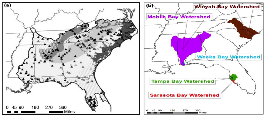
The new version of SPARROW developed in this NASA-funded project will provide end users from the Mobile Bay National Estuary Program, the Tampa Bay Estuary Program, the Sarasota Bay Estuary Program, and both the Weeks Bay and North Inlet – Winyah Bay National Estuarine Research Reserves (NERRs) with a dynamic tool with which they can make near-real time decisions regarding distribution of resources, mitigation activities, land use restrictions, and water quality alerts in their respective sites. The dynamic SPARROW can be used for either hindcasting or forecasting.
All of these environments are under the umbrella of the EPA National Estuary Program (NEP) or NOAA Office of Coastal Management, a collection of 56 (28 NEPs and 28 NERRs) estuaries in the U.S. that have been deemed of national significance. Each program develops and implements respective Management Plans per EPA guidance (Comprehensive Conservation and Management Plan: CCMP) or NOAA guidance (Research Reserve Management Plan: RRMP), long-term plans that contain actions to address water quality and living resource challenges and priorities. The NEPs and NERRs work with local, city, state, federal, private and non-profit stakeholders such as environmental regulatory agencies and planning boards to develop and carry out the CCMPs and RRMPs. These management plans, and associated activities of the NEPs and NERRs, as well as their local, regional, state, and federal partners, form the decision making framework of this project. Other stakeholders of this dynamic SPARROW project include Southwest Florida Water Management District and South Carolina Department of Health and Environmental Control.
Why was a dynamic version of SPARROW important to develop?
The old version of SPARROW has been widely used for long term, steady state water quality analysis, and the users have increasingly asked for a dynamic version of SPARROW that can provide seasonal estimates of nutrients and suspended sediment to receiving waters. Time varying SPARROW outputs will aid water managers in decision making regarding allocation of resources in protecting aquatic habitats, planning for harmful algal blooms, and restoration of degraded habitats, stream segments, or lakes. The spatial and temporal scale of NASA satellite remote sensing products and Land Information System (LIS) modeling data make these sources ideal for the purposes of development and operation of the dynamic SPARROW. So, SPARROW’s dynamic version of this NASA-funded project will provide improved tools for end users to manage water quality in near real time and for the formulation of future scenarios to inform strategic planning.
What role does Landsat play within SPARROW?
Landsat data will be used to map land cover/land use in the study areas. It will also be used to identify disturbed areas that might be sources of sediment and increased phosphorus loading through exposure of the bare soil. Landsat data will be used to detect these seasonal changes in the watershed associated with potential high-impact events (e.g. logging, fires, construction). First a long-term (~ 10 yr) dataset using Landsat 5, 7, and 8 data will be compiled to determine the seasonal statistics of the reflectance for each pixel. Once the historical seasonal statistics of reflectance are determined, a spatial change detection algorithm will then be developed and validated to detect any significant changes to identify potential loading events.
Co-authors:
Mohammad Z. Al-Hamdan
Universities Space Research Association at NASA/MSFC
Richard A Smith
United States Geological Survey (USGS)
Anne Hoos
USGS Tennessee Water Science Center
Gregory E Schwarz
U.S. Geological Survey
Richard B Alexander
United States Geological Survey (USGS)
William L Crosson
Universities Space Research Association at NASA/MSFC
Jayanthi Srikishen
Universities Space Research Association at NASA/MSFC
Maurice Estes
University of Alabama in Huntsville
James Cruise
University of Alabama in Huntsville
Ashraf Al-Hamdan
University of Alabama in Huntsville
Walter Lee Ellenburg
University of Alabama in Huntsville
Africa Flores
University of Alabama in Huntsville
Ward E Sanford
United States Geological Survey (USGS)
Wes Zell
USGS Headquarters
Meredith Reitz
United States Geological Survey (USGS)
Matthew P Miller
USGS
Celeste A Journey
USGS South Carolina Water Science Center
Kevin M Befus
University of Wyoming
Roberta Swann
Mobile Bay National Estuary Program
Tom Herder
Mobile Bay National Estuary Program
Ed Sherwood
Tampa Bay Estuary Program
Jay Leverone
Sarasota Bay Estuary Program
Michael Shelton
Weeks Bay National Estuarine Research Reserve
Erik Tyler Smith
North-Inlet Winyah Bay National Estuarine Research Reserve
Christopher J Anastasiou
Southwest Florida Water Management District
Jennette Seachrist
Southwest Florida Water Management District
Andrea Hughes
South Carolina Department of Health and Environmental Control
David Graves
South Carolina Department of Health and Environmental Control
Funding for this effort is provided by the NASA Applied Sciences Water Resources Program.
Anyone can freely download Landsat data from the USGS EarthExplorer or LandsatLook.
Further Reading:
+ Landsat at #AGU17


