
By Ellie Leydsman McGinty
Forests, in their diverse forms, cover nearly one-third of the Earth’s land surface. From the circumboreal forests of the Northern Hemisphere to the sub-Antarctic Patagonian forests in South America, tree-dominated ecosystems perform vital functions that sustain the biosphere and climate. They provide a myriad of ecosystem services at global, regional, and local scales and serve as a significant source of economic and social value for humankind.
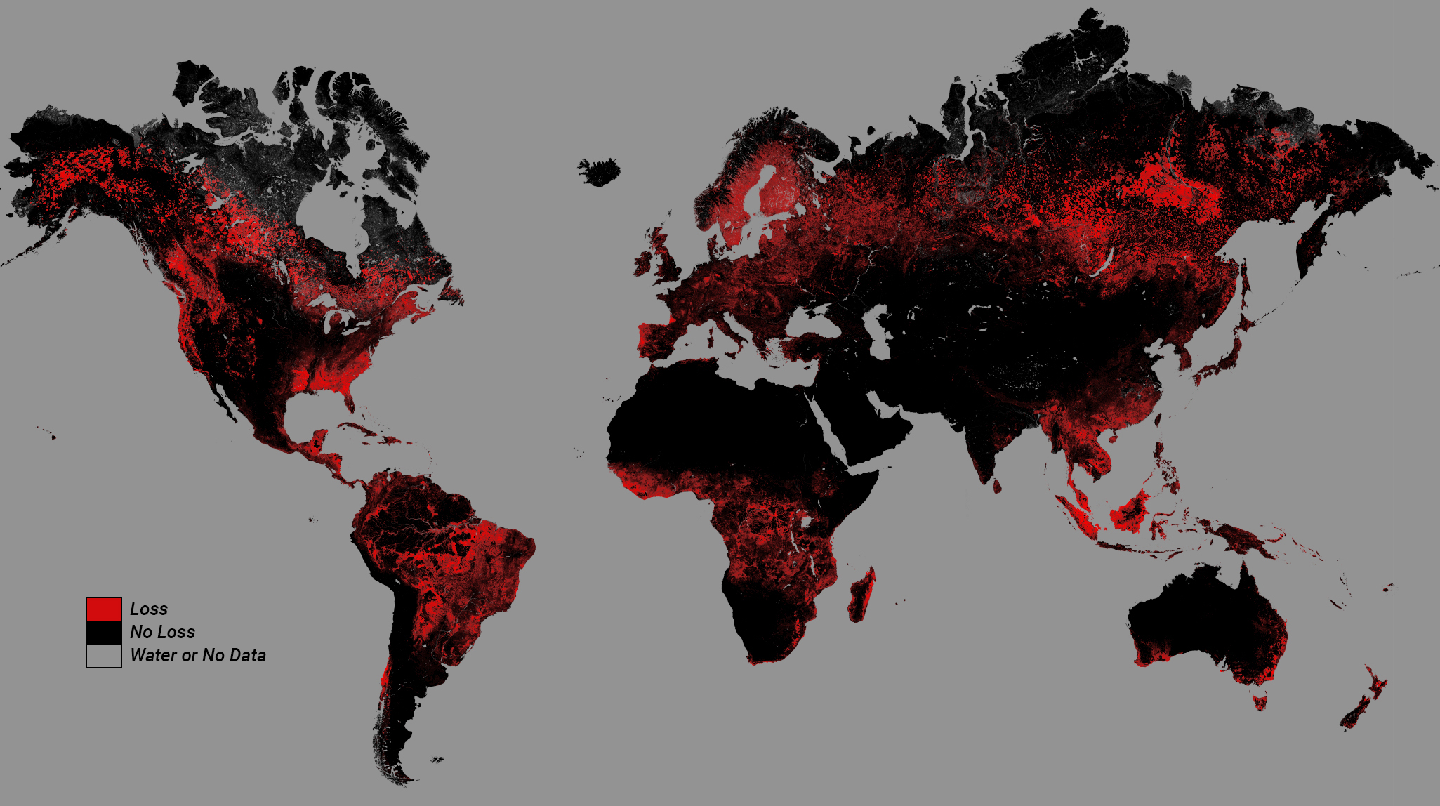
Despite the extraordinary benefits that forests provide, they have long been influenced by human activities and disturbances. Since the dawn of civilization, forests have been altered through timber harvest, fire suppression, and conversion to agriculture. While deforestation has been a common practice for thousands of years, industrialization led to extensive forest loss and degradation. Environmental historians and scientists have estimated that at least 35 percent of the Earth’s pre-agricultural forest cover has been lost over the past 300 years.
Globally, forests continue to face considerable threats. According to the United Nations Food and Agriculture Organization The State of the World’s Forests 2022 report, 420 million hectares of forest were lost between 1990 and 2020. Agricultural expansion and infrastructure development remain a leading culprit of deforestation, fragmentation, and degradation. Overexploitation of timber resources, both legal and illegal, impacts hydrologic regimes, intensifies soil erosion, and destroys wildlife habitat. Climate change, which is exacerbated by deforestation, has altered the frequency and intensity of forest disturbances and modified the composition and distribution of tree and plant species.
The multifaceted challenges confronting forested ecosystems require innovative approaches and technologies. Remote sensing is one such technology that has become a powerful, foundational, and effective component of modern-day forest management and monitoring. Remotely sensed Earth observation data provide valuable insights into forest issues and can pave the way for more comprehensive solutions. Breakthroughs in remote sensing and data science now enable vast volumes of data to be synergistically integrated to further landscape-level understanding and facilitate the formulation of evidence-based strategies.
By fusing multispectral Landsat data with structural data products from the Global Ecosystem Dynamics Investigation (GEDI) mission, researchers and scientists have unlocked a deeper understanding of complex forest processes and dynamics and empowered land managers and policymakers to manage forests with greater effectiveness and sustainability. While numerous studies have explored the synergistic power of Landsat-GEDI data fusion, the examples presented below highlight its potential to characterize forest structure, estimate carbon stocks, and strengthen sustainable forest management.
Ushering in a New Era of Forest Management Through Data Fusion
The last decade has witnessed a transformative shift in remote sensing capabilities. Recent advancements in satellite and sensor technology, as well as computing infrastructure, have led to the exponential growth of data from various spaceborne platforms. The increased volume and types of Earth observation data call for novel analytical approaches to extract meaningful information. Machine learning and data fusion techniques have emerged to efficiently process multiple large datasets and decipher complex environmental and social issues.
Machine learning is a branch of artificial intelligence that automates data analysis and interpretation. It can reveal hidden patterns and relationships and provide more accurate results and predictions. Data fusion—the process of integrating multiple synergistic datasets—is often employed in machine learning environments to generate more holistic pictures of environmental conditions. By fusing data from a variety of sensors and platforms, the strengths of each dataset are leveraged to enhance the quality and completeness of data.
Data fusion frameworks that incorporate Landsat data show great promise in unlocking profound insights for management and conservation applications. Numerous researchers have fused Landsat data with a range of datasets to enrich data and enhance spatial, spectral, and temporal resolutions. Landsat data have been fused with optical, thermal, light detection and ranging (LiDAR), and radar datasets to improve the accuracy of land cover classifications, capture land surface dynamics, and quantify environmental variables.
Multi-sensor remote sensing data fusion has been widely and successfully applied in the fields of forest ecology and forest management to help support a more thorough understanding of forest ecosystem functions, processes, and dynamics. Multispectral Landsat data have been fused with LiDAR data to characterize forest structure and estimate carbon stock. The long-term global Landsat data archive can provide information about forest species distributions and disturbance regimes, while LiDAR data can reveal details about forest canopy height and structure. The results of data fusion provide new opportunities to monitor aboveground biomass and study forest stand structure at regional and global scales.
Seeing Through the Trees With the Global Ecosystem Dynamics Investigation
The advent of spaceborne LiDAR missions, such as GEDI, has had a remarkable impact on forest monitoring and data fusion applications. GEDI—a joint mission between NASA and the University of Maryland—is the first space-based full waveform LiDAR system specifically designed to penetrate dense forest canopy and measure 3D forest structure. The system was launched in December 2018 and subsequently installed on the International Space Station (ISS). From April 2019 to March 2023, GEDI collected data globally (between the latitudes of 51.6°N and 51.6°S latitudes) at a spatial resolution of 25 meters. After having been in storage on the ISS for several months, GEDI will return to its original location in late 2024 and begin collecting data again, possibly through 2030.
The GEDI mission aims to characterize the effects of climate and land use change on ecosystem structure and carbon cycling processes. The GEDI instrument, a laser altimeter, acquires LiDAR waveform observations by recording the amount of laser energy reflected by plant materials at different heights above the ground. The waveforms are used to quantify canopy height, canopy vertical structure, and surface topography. Through sophisticated data processing algorithms, these biophysical parameters are subsequently used to develop higher-level science products, including estimates of aboveground biomass.
During the nearly four years that GEDI data were acquired, scientists have successfully used the data products to advance applications in several natural resource domains. In the forestry sector, these measurements have been used to estimate canopy height in various biomes, characterize forest structure, assess disturbance regimes and growth dynamics, classify forest fuel types, model wildlife habitat and species richness, and evaluate carbon storage. Many of these application areas have been enhanced by integrating Landsat data through data fusion frameworks.
Mapping Global Forest Canopy Height
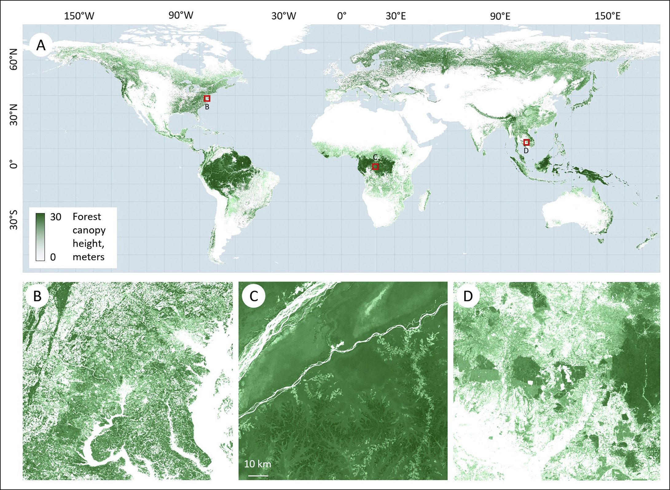
Forest canopy height models play an important role in forest management and conservation. They are used to estimate aboveground biomass and timber volume, monitor forest degradation or restoration, and assess productivity and biodiversity. GEDI data products include waveform interpretations of ground elevation, canopy top height, and relative height. While these metrics provide near-global coverage of forest structure, the spatially discrete sampling scheme can lead to the omission of rare or local forest disturbances, particularly in topographically and structurally diverse regions.
To improve upon the GEDI forest canopy height model, researchers from the University of Maryland and NASA Goddard Space Flight Center (Potapov et al., 2021) integrated GEDI-derived canopy height data with multitemporal Landsat surface reflectance data to develop a global 30-meter spatial resolution map of forest canopy height. Using a per-pixel machine learning algorithm, a methodology for extrapolating the LiDAR-based sampled forest structure was implemented using the Landsat Analysis Ready Data (ARD) product created by the Global Land Analysis and Discovery (GLAD) team at the University of Maryland. The study illustrated that the integration of spaceborne optical and LiDAR data sets enables multidecadal global annual forest canopy height monitoring. The forest canopy height model was shown to detect stand-replacement dynamics, as well as forest degradation and recovery.
Quantifying Aboveground Biomass
Forests play a critical role in moderating the global carbon cycle and mitigating the impacts of climate change through carbon sequestration. Estimating aboveground biomass in forests is central to understanding carbon storage and quantifying carbon emissions from deforestation and degradation. Machine learning frameworks that exploit the structural information from GEDI data products and the long-term time series data from the Landsat program can lead to more accurate quantifications of aboveground biomass and estimates of carbon loss.
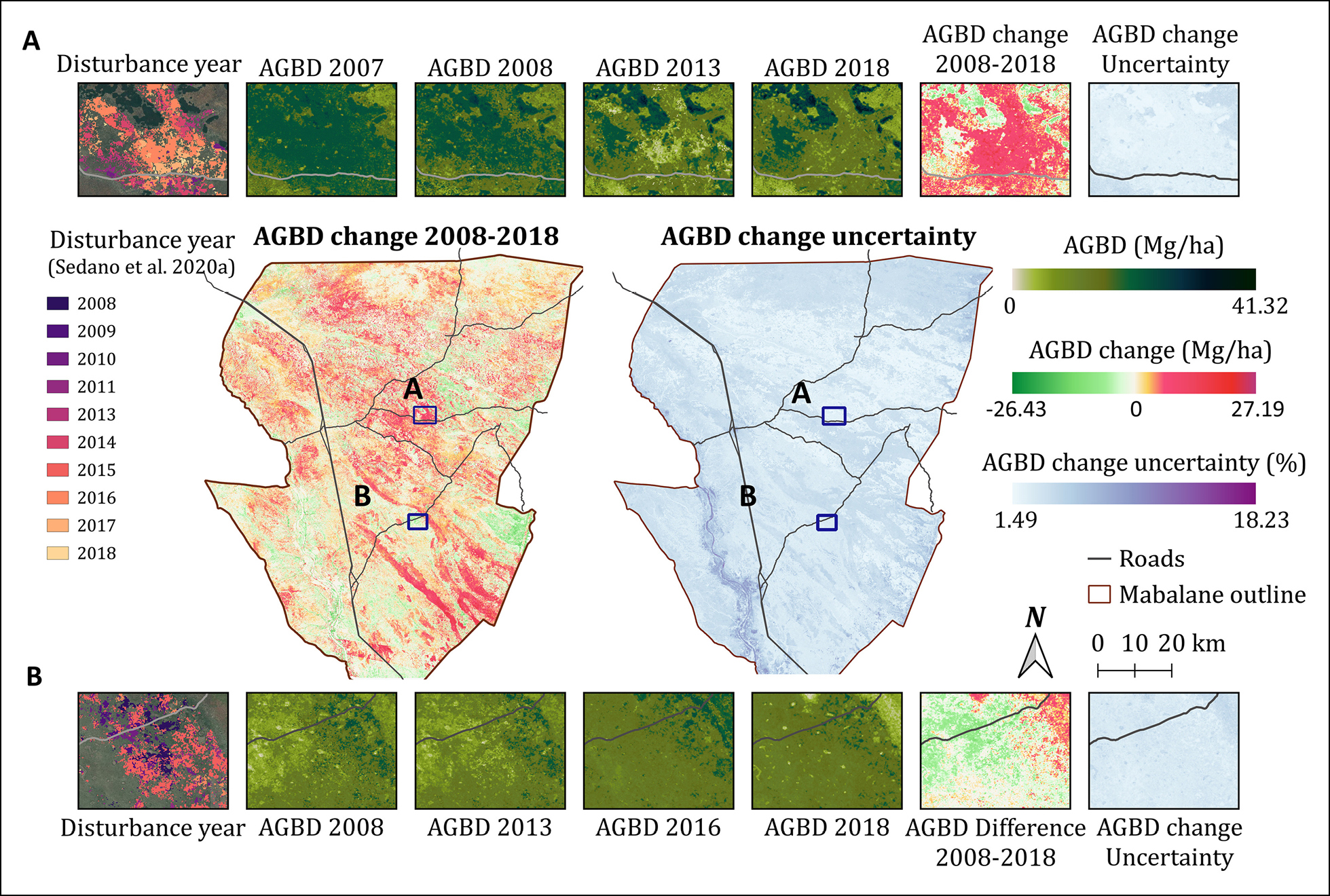
Scientists from the University of Maryland and the European Commission’s Joint Research Centre (Liang et al., 2023) developed a novel data fusion approach using GEDI and Landsat data to assess biomass losses associated with charcoal-related forest degradation in the Mabalane District in southern Mozambique. Charcoal production has become a primary driver of degradation in the dryland forest and woodland ecosystems of Sub-Saharan Africa and it is predicted to accelerate in response to the growing urban energy demand. To respond to the need for timely monitoring of charcoal production and degradation, annual aboveground biomass maps from 2007 to 2019 were constructed to enable the characterization of disturbance and recovery. The framework presented in this study demonstrated that fusing GEDI and Landsat data through predictive modeling can be used to quantify past and present estimates of aboveground biomass density in low biomass forests.
Classifying Forest Fuel Types
Forest fires are one of the most common disturbances in forested ecosystems across the globe. While they are naturally occurring phenomena, their prevalence is increasing, with the number and intensity of fires rising in recent decades. This trend is driven by complex factors, including climate change and human activities. The impacts of severe wildfires are far-reaching and can contribute to soil erosion, biodiversity loss, carbon emissions, and community damage. The growing threat of wildfires requires forest managers to better understand fire behavior and risk. Forest fuel models can provide this valuable information and serve as a key step in forest fire management and prevention.
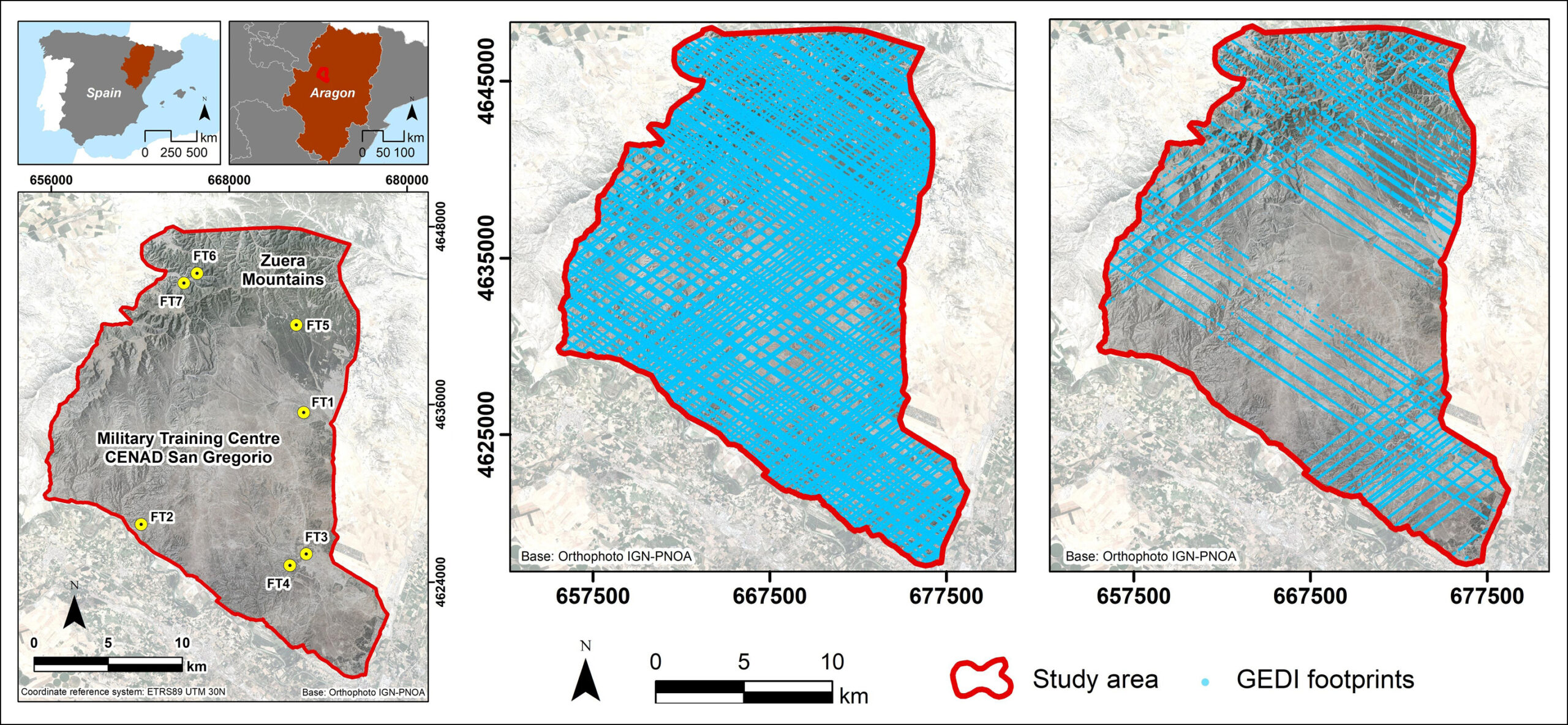
LiDAR data sets are particularly useful for classifying forest fuels because they can yield measurements of vegetation height, crown density, and biomass volume. When coupled with multispectral imagery, enhanced forest fuel models can be generated to provide greater insights into fire behavior. Researchers from Spain (Hoffrén et al., 2023) assessed the capability of GEDI data and Landsat variables to estimate forest fuel types in Northeastern Spain based on a Mediterranean-adapted fuel types model (i.e., the Prometheus model). The study revealed that GEDI data products alone provide useful information for classifying fuel types, but high rates of confusion were reported in shrub fuel types. These limitations were minimized by integrating Landsat derivatives into the forest fuels model, thus improving the overall accuracy and reducing confusion between fuel types.
Characterizing Forest Wildlife Habitat
Forests provide an abundance of resources and habitat types and serve as havens of biodiversity. The complex structure of forests, characterized by diverse canopy layers and microclimates, offers an intricate array of habitats that harbor the majority of Earth’s terrestrial species. To gain a deeper understanding of forest habitat types, distribution, and loss, spatiotemporal data about ecological patterns and processes are becoming increasingly salient. Improved wildlife habitat modeling efforts often include measures of forest structure, such as canopy height, canopy cover, and foliage height diversity. These measures can be obtained by implementing data fusion frameworks that integrate multiple satellite-derived datasets.
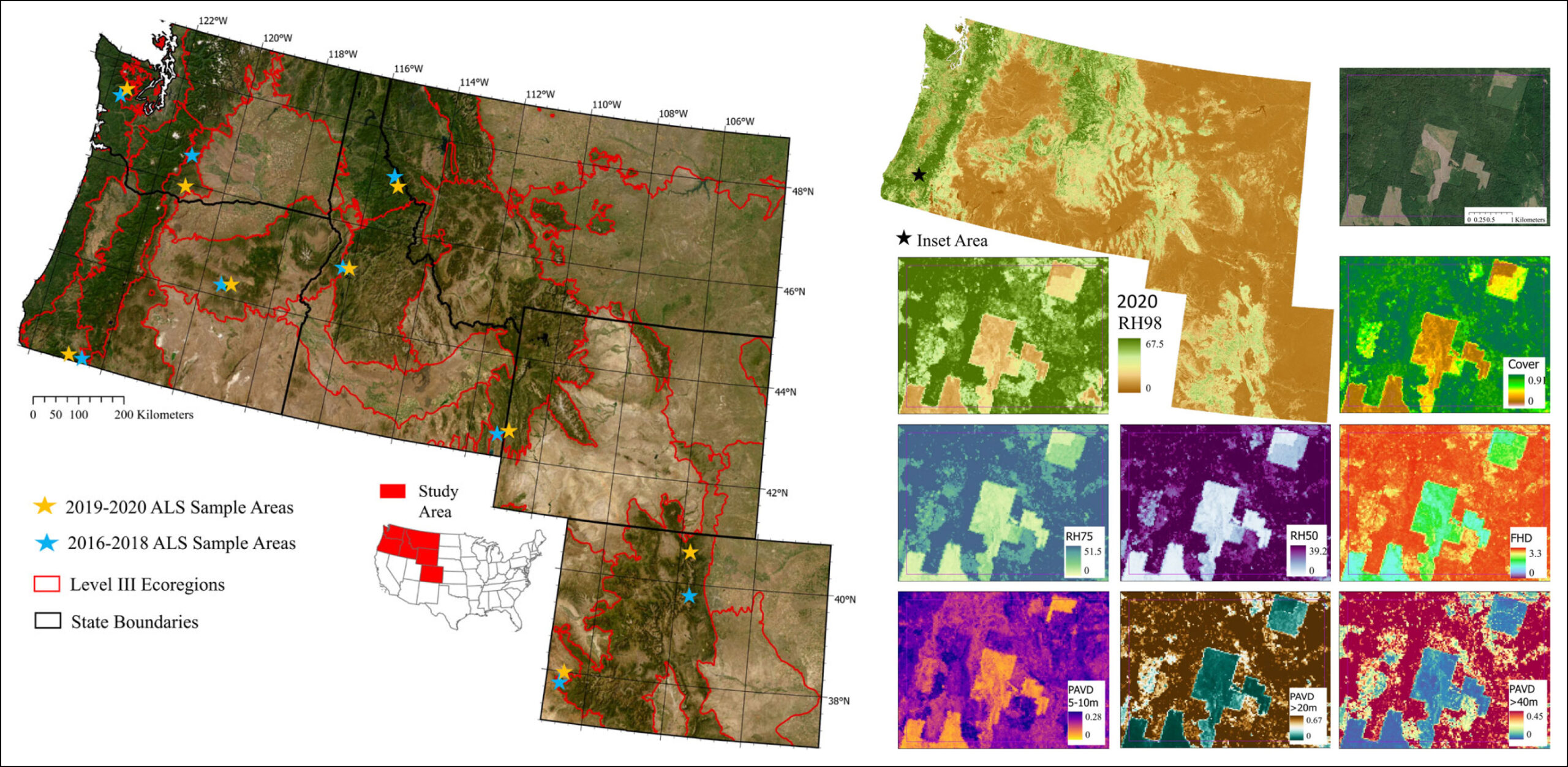
Natural resource scientists in the Western United States (Vogeler et al., 2023) conducted a multi-pronged study that evaluated the use of GEDI and Landsat data in wildlife habitat modeling applications across six western states, from Washington to Colorado. One of the objectives was to examine wildlife habitat models for three cavity-nesting keystone woodpecker species with varying forest structure needs across a range of forest types and ecoregions. Wildlife habitat models were created for the Downy woodpecker, northern flicker, and pileated woodpecker using GEDI-fusion datasets and other predictor variables. Habitat extent and distribution were successfully modeled by incorporating forest structure metrics. The results of the study show promise for supporting forest wildlife habitat modeling efforts across broad and ecologically diverse extents. Additionally, the reliance on Landsat data provides opportunities to hindcast the wildlife habitat models using the decades-long Landsat record.
Transforming Data Into Informed Decision-Making
Since 1972, the Landsat program has provided continuous observations of the Earth’s land surfaces, giving researchers, scientists, and resource managers an invaluable avenue for monitoring and assessing global environmental change. From its inception, the Landsat program single-handedly changed how the Earth was viewed and how critical natural and cultural resources were managed. As the Landsat data archive expanded, time-series analyses permitted a more comprehensive understanding of complex and dynamic ecosystems. The insights gained from these scientific investigations promoted more informed decision-making and policy development.
Today, with the prevalence of Earth observation data and publicly accessible cloud computing infrastructure, the potential for data-driven decision-making has reached an unprecedented level. By leveraging technological innovations, such as machine learning and data fusion, resource managers and policymakers can transform actionable data into informed decisions that lead to better and more sustainable outcomes for society and the Earth.
To learn more about how Landsat data are being fused with GEDI data, watch ExtraDimensional – The Fusion of Landsat & GEDI Data.


