UNOSAT Maps Flood Extent Near Lake Urmia with Landsat 8

UNOSAT Maps Flood Extent Near Lake Urmia with Landsat 8

Source: UNOSAT

flood waters south of Lake Urmia
This map illustrates the satellite-detected waters extent south of Lake Urmia (in the county of Mahabad in the West Azerbaijan province of Iran) as observed from the Landsat 8 image acquired on April 16, 2017. Within the area of 21,000 ha covered by this map, 2,970 ha of lands appear to be potentially affected. This corresponds to 13% of the analyzed area. The flooded areas appear to be mainly agricultural zones and about 8 km of roads seem to be potentially affected. Please note that some areas were cloud covered and could not be analyzed.

The United Nations’s Operational Satellite Applications Program (UNOSAT) uses satellite data and geographic information systems to map natural hazards and other time-sensitive events in order to provide UN decision makers, along with aid agencies and member states, with high-quality, timely information about events on the ground. The group’s mission is “to deliver integrated satellite-based solutions for human security, peace and socio-economic development.”
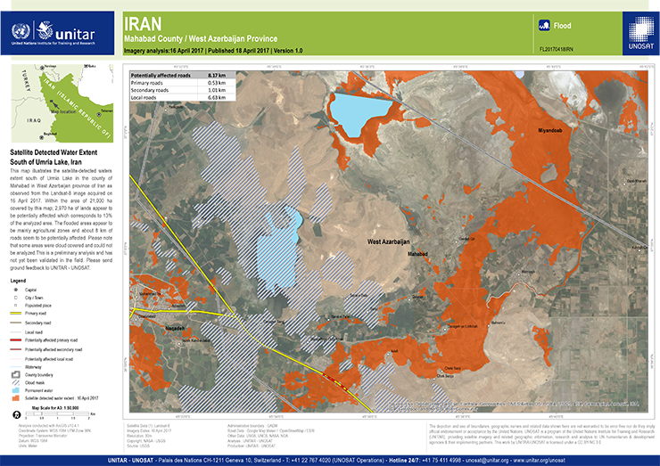
The map featured above is a Landsat 8-based map showing regions south of Iran’s Lake Urmia that have been effected by recent flooding.
Further Information:
+ Satellite Detected Water Extent South of Urmia Lake, Islamic Republic of Iran

Post Last Updated on April 19, 2017
On Key

Recent Posts

Landsat image of a Klamath reservoir after dam removal. A skinny dark band shows a river surrounded by silty formerly-submerged lands.

Undamming the Klamath

Between October 2023 and October 2024, the four dams of the Klamath Hydroelectric Project were taken down, opening more than 400 miles of salmon habitat.

Read More »
On Key

Related Posts

Landsat image of a Klamath reservoir after dam removal. A skinny dark band shows a river surrounded by silty formerly-submerged lands.

Undamming the Klamath

Between October 2023 and October 2024, the four dams of the Klamath Hydroelectric Project were taken down, opening more than 400 miles of salmon habitat.

Read More »