Contributor: Vicky Fakan, USAID

USAID has long been a major actor helping to conserve Guinea’s forest reserves, which replenish many of West Africa’s life-sustaining waterways. Now, a recent partnership between USAID and the U.S. Geological Survey (USGS) can better measure just how well these efforts are working. Officials from the two agencies believe the system—which analyzes decades’ worth of satellite data to measure impact—just may revolutionize forest and conservation monitoring worldwide.
“Before this partnership, only about a third of worldwide forest conservation programs had monitoring and evaluation systems in place, so we have been unable to concretely track long-term improvements or setbacks,” said USAID/Guinea Mission Director Nancy Estes. “The use of remote sensing technology is revolutionary because it has creatively solved the problem and allows us and our Guinean partners to see with our own eyes the results of our work in preserving Guinea’s forests.”
For 18 years, USAID has pioneered conservation by increasing the involvement of local people in the management of four of Guinea’s forest reserves, which cover more than 350 square miles. This approach decentralizes control from the Guinean Forestry Department to local communities, whose welfare depends on ensuring that their environment is managed sustainably.
Although locals have great pride in the projects, it had always been difficult to concretely measure the extent and quality of the program’s impact. “Early biodiversity programs did not undertake widespread agriculture or income surveys, nor were they able to invest in costly satellite surveys to run ongoing comparisons,” said Ibrahima Camara, USAID/Guinea’s rural development specialist. Until recently, the impact has been hard to gauge.
The new collaboration between USAID and the USGS Earth Resources Observation and Science (EROS) Center in South Dakota is exploring a promising new way to assess the effects of conservation work by analyzing decades of satellite data in areas where USAID projects have been active.
A Bird’s Eye View
For almost 40 years, EROS—which has been working with USAID missions in West Africa since 1987—has collected and archived satellite images of the Earth’s land surface. Its images, taken by civilian satellites, have traditionally been used for research and a wide range of environmental, development, and conservation purposes.
For example, the center has collected a series of images taken by NASA-USGS Landsat satellites, which have a moderate spatial-resolution. That means viewers can’t distinguish fine detail, such as single homes, on a Landsat image, but they can easily see large structures such as roads and areas of general urban development. “With these images, you can easily see the patterns of natural and human landscapes and where and how humans are impacting their environment,” says Gray Tappan, a geographer with USGS.
Since 1972, users worldwide have been able to purchase Landsat images from the USGS EROS. In 2008, USGS decided to make its worldwide Landsat archive available to the public, at no cost. EROS now shares this treasure trove with policy makers, scientists, educators, and significantly, development agencies such as USAID.
The Big Reveal
To determine the real impact of USAID’s 18 years of comanagement projects in Guinea, the USAID mission teamed up with EROS in 2008 to undertake some sophisticated before-and-after comparisons. Using 40 years’ worth of imagery, including the Landsat series, the USAID-EROS partnership has successfully tracked how forest conditions changed over time, both in the areas that received USAID assistance and in areas that did not. All four of the forest reserves supported by USAID have shown remarkable progress.

The images show that in Nyalama Forest Reserve in northwestern Guinea, the community has respected an important chimpanzee habitat. In Souti-Yanfou Forest Reserve in southwestern Guinea, they show evidence that two decades of chaotic slash-and-burn agriculture has been superseded by management practices that emphasize the need to look after the forests in the long term. Forest cover is visibly denser and evidence of this regeneration is confirmed by locals, who say that water sources that had dried up are now flowing.
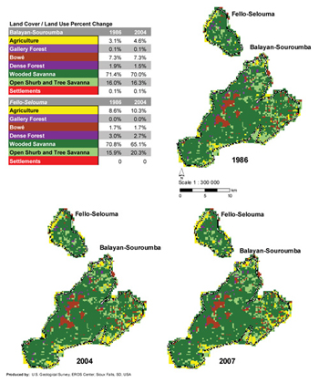
In neighboring Balayan-Souroumba and Sincerey-Oursa Forest Reserves, the images also show that tree density is better now than in the 1960s. “The empowerment of the local communities has delivered tremendous outcomes, with locals actively planting trees and going so far as to reduce destruction by relocating entire villages to less sensitive sites,” says Estes. By contrast, the imagery shows that the Fello-Selouma Reserve, which remained outside USAID’s project area, has been subject to creeping agricultural encroachment and steady deforestation.
In most cases, the reserves are now in better condition than at any time since the 1986 set of images. While this partnership uses satellite images to look downward, one local says that now, “we see a way forward.”
“The results are not only a source of optimism and hope for Guinea’s forests, but the information is already being used by USAID’s partners to identify what works and to help guide future conservation activities throughout the region,” says Greg Booth, who worked on the partnership before becoming the U.S. Department of Agriculture regional program manager for Armenia and Georgia.
A Model for the Mano River
Thanks to the evidence generated by the USAID-EROS efforts, the partnership’s boundaries have expanded outside of the USAID project areas. Although the Guinean Forestry Department has given up some direct control over forest management, the effectiveness of the community approach has won the authorities over. This form of forest regulation is now a government imperative for all of Guinea’s forest reserves. Said one government agency representative: “We are now educators, not policemen,” and “our victory is if the experiences of comanagement are shared and used elsewhere.”
Indeed, this positive philosophy is already spilling over Guinea’s borders into the whole Mano River region, including Ivory Coast, Liberia, and Sierra Leone. USAID is working with partners there to implement action plans to extend effective forest-management practices through the Mano River Forestry Initiative.
“This creative partnership between USAID and USGS has not only generated a new and inexpensive way of monitoring and benchmarking the impact of this project in Guinea,” says Booth. “It has also provided a solid basis for conservationists everywhere to illustrate, justify, and share information about what works.”
Further information:
+ “When You Can’t See the Forest for the Trees….” USAID

Be Part of What’s Next: Emerging Applications of Landsat at AGU24
Anyone making innovative use of Landsat data to meet societal needs today and during coming decades is encouraged to submit and abstract for the upcoming “Emerging Science Applications of Landsat” session at AGU24.


