
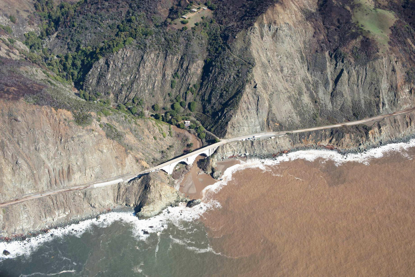
In California, climate change contributes to hotter, drier summer conditions which lead to more frequent and intense wildfires. Added to this are climate-driven shifts in precipitation patterns, resulting in longer dry spells that are sometimes broken by intense rainfall and flooding. The sequence of these combined hazards can lead to dramatic morphological changes in coastal watersheds, as sediments liberated by fire and flood are washed downslope, downstream, and eventually to beaches.
A new study by researchers at the USGS Pacific Coastal and Marine Science Center in partnership with colleague Kilian Vos of the University of New South Wales combines decades of coastal satellite imagery with hydrologic and oceanographic data to look at how changes on land affect coastlines in Big Sur, California. One surprising finding: An intense wildfire in 2016, followed by record rainfall and major flooding, mobilized and deposited enough sediment to grow Big Sur’s beaches to their widest extent of the entire 36-year data record.
“Beaches are vulnerable to sea-level rise and coastal erosion, and sediment discharge from rivers is a natural beach-nourishment process,” said Jonathan Warrick, USGS Research Geologist at the Pacific Coastal and Marine Science Center (PSMSC) and lead author of the study. “Our study shows how wildfire directly contributes to this process—potentially sustaining beaches over long timescales with periodic bursts of sand— which may happen more frequently with climate change.” Sediment traveling downstream from rivers to the coast is usually deposited nearshore, nourishing coastlines with a new supply of sediment. Coastal processes such as wind, waves and currents work inexorably to erode material from coasts, and the delivery of river sediment to the beach serves to counterbalance the erosion.
Climate change ramps up both erosional and depositional processes along our coasts. Not only will coastal erosion increase through rising sea levels and more frequent and intense storms, but coastal deposition will likely increase as well, as more frequent, intense fires are followed by flood events that wash enormous volumes of sediment into the sea.
“Not only are these events projected to be more frequent and more intense because of climate change, but they are actually already documented as being more intense and more frequent because of climate change,” said Amy East, USGS Research Geologist at PCMSC and a co-author of the study. “There’s already a lot of literature out there showing that California’s fires have intensified because of climate change, and that flood frequency and magnitude are already increasing because of climate change. This study shows how these intense wildfires affect not only the watershed but coastlines downstream. It’s a direct link between what’s happening on land and what’s happening along our coasts because of climate change.”
“The study opens the door for more research into how climate-driven natural hazards will continue to shape coastal processes such as erosion and deposition,” said East. “Our next step is modeling whether the sediment output to the coast is likely to change or increase in the coming decades because of these increased fire and flood frequencies onshore.”
“This novel approach links several natural hazards—coastal erosion, wildfire, flooding—that are typically treated as separate or unrelated events, illustrating the important role that watersheds play in coastal erosion management,” said Sean Vitousek, USGS Research Oceanographer at PCMSC and a co-author of the study. “Using satellite imagery gives us access to a continuous record of shoreline-change data, something that can be very difficult and time-consuming to obtain using traditional on-the-ground surveys. This study demonstrates how remote-sensing techniques such as satellite-derived shoreline data will become increasingly important to understanding large-scale coastal change.”


