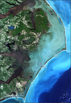
Researchers Matthew Stutz and Orrin Pilkey were able to find undocumented barrier islands using a global collection of Landsat images together with topographic and navigational charts. The Landsat images were acquired circa 2000 and mosaicked together by Earthsat as part of the Geocover project funded by NASA and USGS.
The world’s largest chain of barrier islands was discovered in equatorial Brazil, just south of the mouth of the Amazon River. The island chain includes 54 islands that together stretch more than 350 miles. Brazil along with Madagascar and Australia yielded the most extensive undocumented island chains. Most of the newly discovered islands, however, were not major island chains, but cumulatively they account for the massive jump in the global number and length of barrier islands.
The four nations with the most barrier island miles are the United States (24 percent), Mexico (11 percent), Russia (8 percent), and Australia (7 percent). Nearly a quarter of all barrier islands are found in the Arctic. These islands are most vulnerable to the effects of climate change. The permafrost that previously fortified these islands is thawing and at the same time the sea ice that once protected the islands from destructive wave action is present for shorter portions of the year. Erosion rates in Alaska’s Beaufort Sea are 6.5 feet per year on average.
Barrier islands are ephemeral; they are sediment build-ups greatly affected by wave action, tides, and severe storm events. Climate change is the largest influence on sediment supply to barrier islands, so we can expect barrier islands to be dramatically altered with a changing climate and rising sea levels. This “underscores the need to improve our understanding of the fundamental roles these factors have played historically in island evolution, in order to help us better predict future impacts,” Pilkey explains. As population growth surges toward the sea, barrier islands are retreating due to sea level rise, storm activity, and reduced sediment supply; all necessitating a better understand of barrier island processes.
Further Information:
+ Stutz, M.L. and O.H. Pilkey (2011). “Open-Ocean Barrier Islands: Global Influence of Climatic, Oceanographic, and Depositional Settings.” Journal of Coastal Research, vol.27, no. 2, pp. 208–222.
+ Duke Press Release [external link]
+ “More barrier islands on Earth than previously thought,” EarthSky [external link]
+ “Hundreds of Islands New to Science,” DiscoveryNews [external link]

Be Part of What’s Next: Emerging Applications of Landsat at AGU24
Anyone making innovative use of Landsat data to meet societal needs today and during coming decades is encouraged to submit and abstract for the upcoming “Emerging Science Applications of Landsat” session at AGU24.


