Landsat’s Role in Managing Ecosystems and Biodiversity
Our world is made of complex networks of living things and physical elements that constantly interact and affect each other. Such networks are known as “ecosystems.” Healthy and economically important ecosystems such as temperate forests, wetlands, grasslands, coastal zones, coral reefs, and rainforests all play roles in human life. For example, farm and rangeland ecosystems must be healthy to produce the grains and livestock on which we depend as a nation. Marine ecosystems depend on the health of land ecosystems, because coastal areas provide habitat needed to support the productivity and diversity of aquatic organisms. Landsat has brought valuable capabilities to ecosystem studies. Landsat instruments measure reflected light in visible and infrared wavelengths. Because plants reflect little visible light and a lot of infrared light when they are healthy, the measurement of both types of light simultaneously gives scientists a way to assess plant health and density over a landscape. Measurements are detailed enough while still covering a wide area that ecologists can expand their interpretations of local events and processes, such as an insect infestation in a specific forest, to a regional scale. This helps them to gauge the health of larger ecosystems. Because Landsat data are accurately mapped to reference points on the ground and adjusted for topographic relief, they can be integrated with other geographic data sets and models to explore more complex studies of ecosystems and biodiversity across space and time.
![A false color Landsat image showing a small portion of Australia's Gulf of Carpentaria](https://landsat.gsfc.nasa.gov/wp-content/uploads/2019/12/Gulf-of-Carpentaria-fc-768x272-1.png)
Mapping the Mighty Mangrove
A new longitudinal study from Australia has harnessed thirty years of NASA/USGS Landsat data to map the nationwide movement and migration of mangrove forests.
![tornado damage](https://landsat.gsfc.nasa.gov/wp-content/uploads/2019/07/tornado-damage-1.jpg)
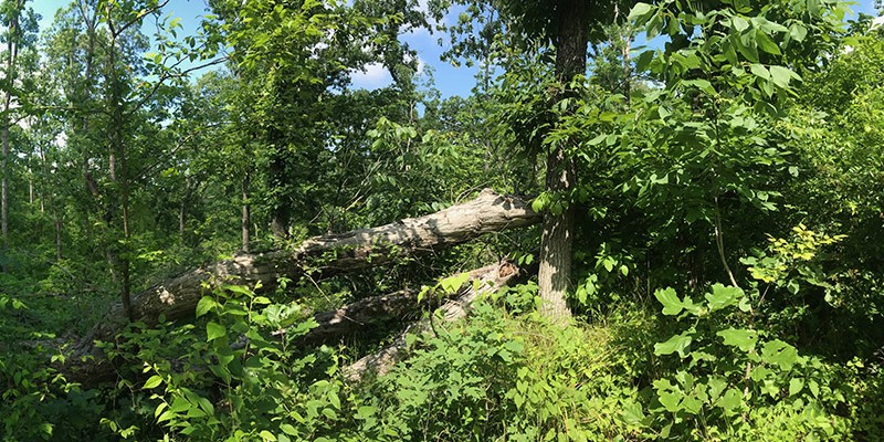
Tornadoes, Windstorms Pave Way for Lasting Plant Invasions
Landsat shows that large blowdown areas in southern Illinois forests are more heavily invaded by invasive species and slower to recover than smaller areas after a tornado.
![Aerial photograph of Mount Michael](https://landsat.gsfc.nasa.gov/wp-content/uploads/2019/07/Mount-Michael.-Credit-Pete-Bucktrout-British-Antarctic-Survey-1024x483-1.jpg)
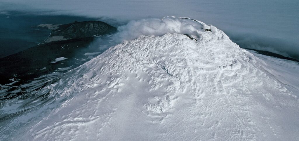
Landsat Aids Discovery of Rare Lava Lake on Remote Sub-Antarctic Island
Landsat, Sentinel-2, and ASTER confirm a rare lava lake in Mt. Michael’s crater on the sub-Antarctic Saunders Island—a “remarkable geological feature.”
![Eastern Reef Egret](https://landsat.gsfc.nasa.gov/wp-content/uploads/2021/10/EasternReefEgretQueensland.png)
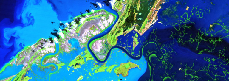
More than Naught: The “Z” of Where Land Meets Sea
Harnessing 30 years of Landsat data, a team of researchers from Australia has created the first 3D model of Australia’s entire coastline.
![Landsat-mapped spread of Prosopis](https://landsat.gsfc.nasa.gov/wp-content/uploads/2019/05/figure1-CABI-pressrelease-2000x2053.png)
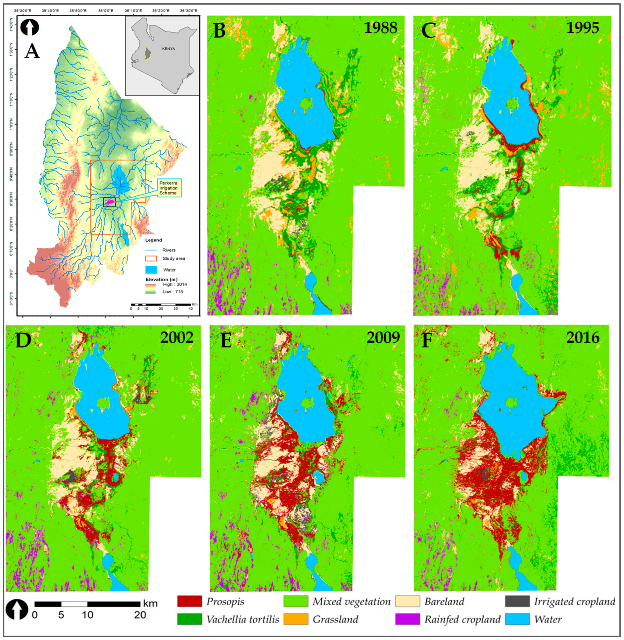
Containing a Woody Weed in Kenya
Prosopis was introduced to Kenya in the 1980s to provide fuelwood; it has since turned into an environmental scourge. Landsat has tracked its fast-paced spread.
![This map shows land cover in the conterminous U.S.](https://landsat.gsfc.nasa.gov/wp-content/uploads/2019/05/NLCD_2016_Landcover-1.jpg)
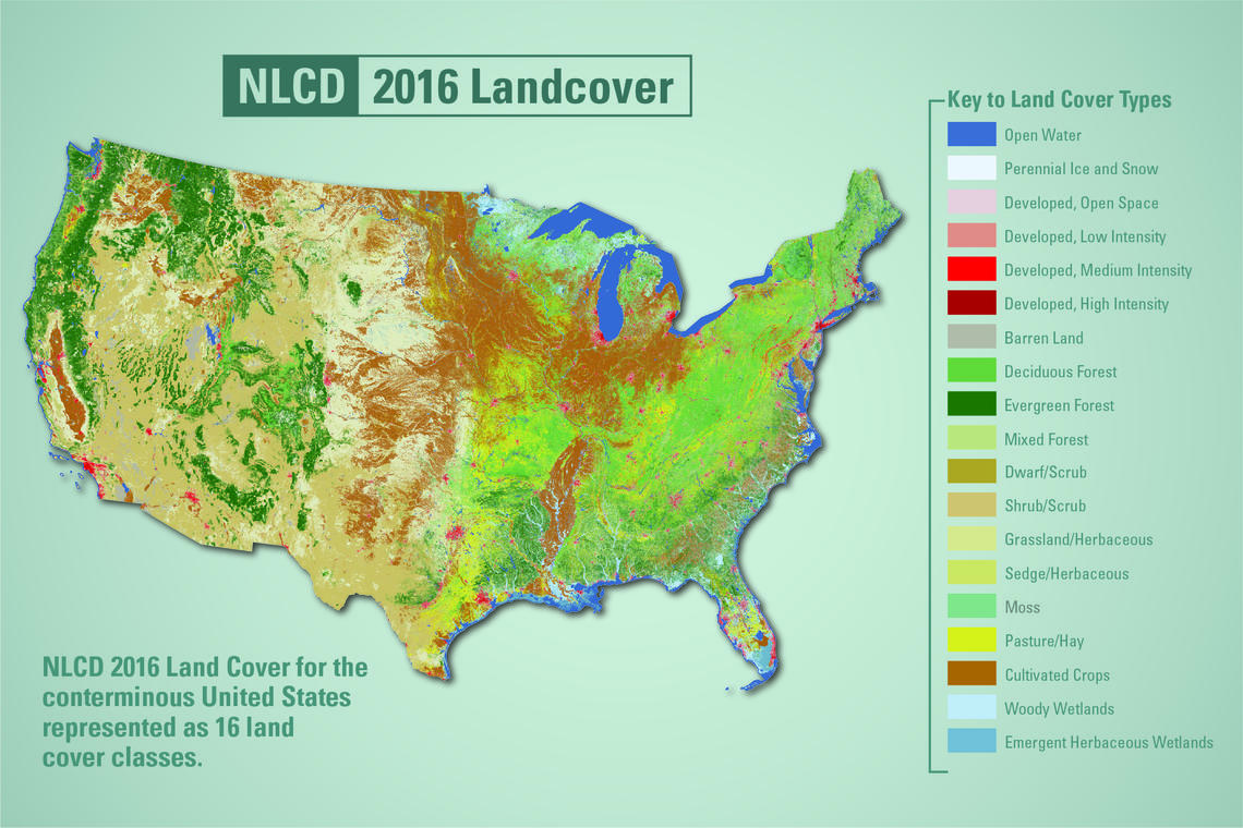
New Land Cover Maps Depict 15 Years of Change Across America
USGS released the latest edition of the National Land Cover Database (NLCD) for the U.S.—the most comprehensive land cover database that the USGS has ever produced.