
Critical Milestone Reached for 2012 Landsat Mission
Source: Rani Gran, NASA/GSFC; Jon Campbell, USGS; Roz Brown, BATC The Operational Land Imager (OLI), built by Ball Aerospace & Technologies Corp., Boulder, Colo., has been approved by NASA Goddard
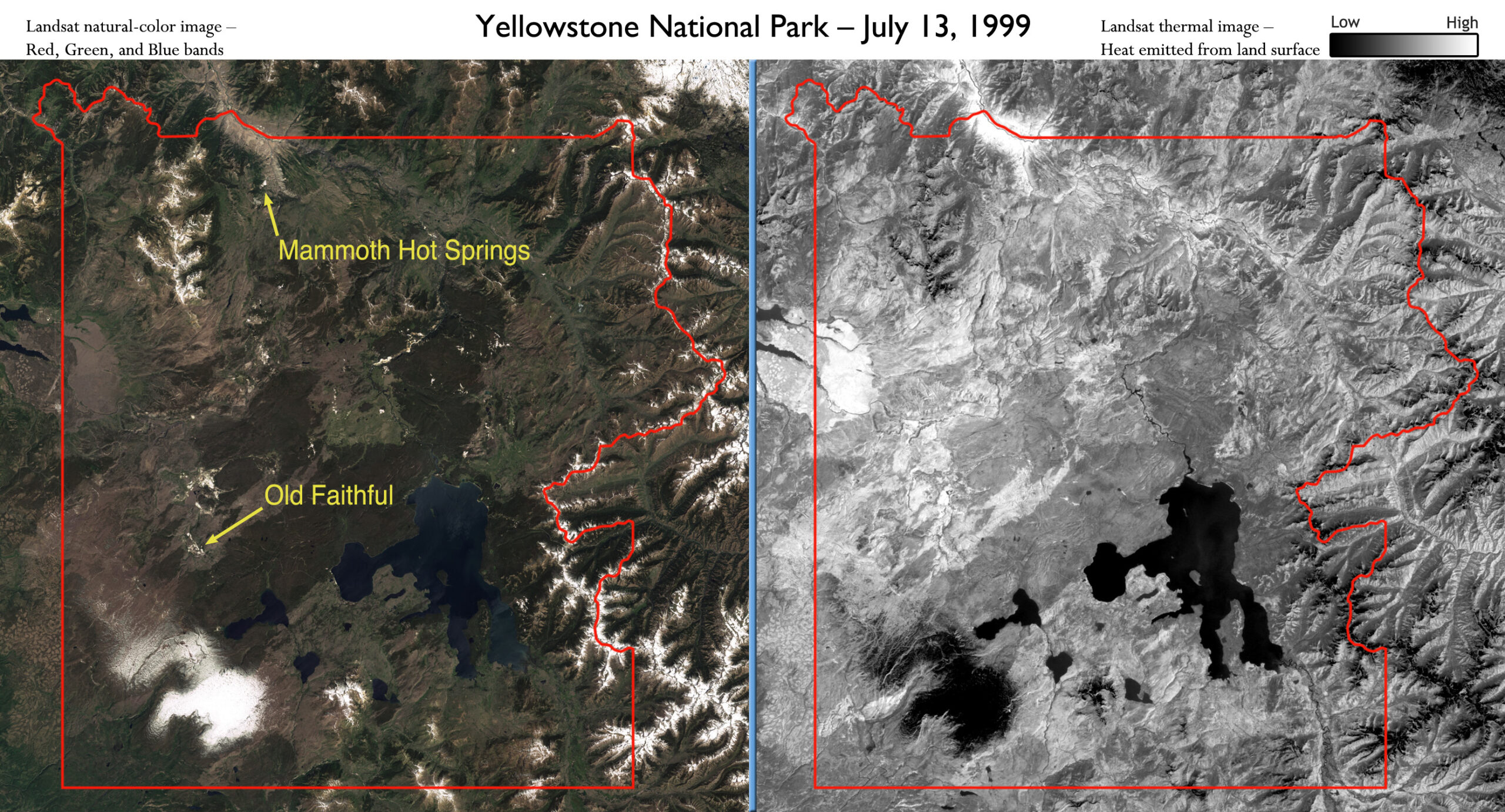
Landsat Satellites Track Yellowstone’s Underground Heat
Yellowstone National Park sits on top of a vast, ancient, and still active volcano. Heat pours off its underground magma chamber, and is the fuel for Yellowstone’s famous features—more than
Landsat Update – Volume 5 Issue 3 2011
The USGS Landsat Update is now available. Articles include: Landsat Images on Display at the Library of Congress Landsat Document Donation Wind, Fire, and Water Landsat Technical Working Group Meeting Held Upcoming
Landsat-Based Maps Aid German Relief Work in East Africa
Eastern Africa is in the grip of the worst drought it has seen in 60 years and the region is facing severe famine. In Somalia alone, it is estimated that
Landsat Satellites Track Continued Missouri River Flooding
Flooding along the Missouri River continues as shown in recent Landsat satellite images of the Nebraska and Iowa border. Heavy rains and snowmelt have caused the river to remain above
Monitoring Waterbird Habitat
In an article published this month in The International Journal of Avian Science,Spanish researchers used Landsat data to map waterbird habitat in rice paddies adjacent to the Doñana National Park in
LDCM Operational Land Imager (OLI)—VIS/IR Instrument
Special Topics: LDCM and LDCM Components The Operational Land Imager (OLI) is being built by the Ball Aerospace and Technologies Corporation. The Ball contract was awarded in July 2007. OLI
Landsat 5 Captures Missouri River Flooding Near Omaha
Landsat 5 captured an image of flooding occurring along the Iowa/Nebraska border on June 30, 2011. Flooding is still occurring on July 6, and Flood Warnings are still in effect
The Calibration Subsystem for LDCM's Operational Land Imager
Special Topics: LDCM and LDCM Components The Calibration Subsystem for the Operational Land Imager (OLI) on LDCM uses both the sun and the absence of light to establish the light
Critical Milestone Reached for 2012 Landsat Mission
Source: Rani Gran, NASA/GSFC; Jon Campbell, USGS; Roz Brown, BATC The Operational Land Imager (OLI), built by Ball Aerospace & Technologies Corp., Boulder, Colo., has been approved by NASA Goddard
Landsat Satellites Track Yellowstone’s Underground Heat
Yellowstone National Park sits on top of a vast, ancient, and still active volcano. Heat pours off its underground magma chamber, and is the fuel for Yellowstone’s famous features—more than
Landsat Update – Volume 5 Issue 3 2011
The USGS Landsat Update is now available. Articles include: Landsat Images on Display at the Library of Congress Landsat Document Donation Wind, Fire, and Water Landsat Technical Working Group Meeting Held Upcoming
Landsat-Based Maps Aid German Relief Work in East Africa
Eastern Africa is in the grip of the worst drought it has seen in 60 years and the region is facing severe famine. In Somalia alone, it is estimated that
Landsat Satellites Track Continued Missouri River Flooding
Flooding along the Missouri River continues as shown in recent Landsat satellite images of the Nebraska and Iowa border. Heavy rains and snowmelt have caused the river to remain above
Monitoring Waterbird Habitat
In an article published this month in The International Journal of Avian Science,Spanish researchers used Landsat data to map waterbird habitat in rice paddies adjacent to the Doñana National Park in
LDCM Operational Land Imager (OLI)—VIS/IR Instrument
Special Topics: LDCM and LDCM Components The Operational Land Imager (OLI) is being built by the Ball Aerospace and Technologies Corporation. The Ball contract was awarded in July 2007. OLI
Landsat 5 Captures Missouri River Flooding Near Omaha
Landsat 5 captured an image of flooding occurring along the Iowa/Nebraska border on June 30, 2011. Flooding is still occurring on July 6, and Flood Warnings are still in effect
The Calibration Subsystem for LDCM's Operational Land Imager
Special Topics: LDCM and LDCM Components The Calibration Subsystem for the Operational Land Imager (OLI) on LDCM uses both the sun and the absence of light to establish the light
