News Archives
Wetland Restoration Challenges
A recent publication inGeophysical Research Letters has called into question the effectiveness of current wetland restoration methods. Using more than two decades worth of Landsat data, Dr. Michael Kearney of the
Six Million Landsat Scenes Downloaded for Free
Source: USGS Landsat Program The U.S. Geological Survey’s Landsat group has announced that the six-millionth free Landsat scene has been downloaded from the USGS archive. USGS made Landsat data available for
Critical Milestone Reached for 2012 Landsat Mission
Source: Rani Gran, NASA/GSFC; Jon Campbell, USGS; Roz Brown, BATC The Operational Land Imager (OLI), built by Ball Aerospace & Technologies Corp., Boulder, Colo., has been approved by NASA Goddard
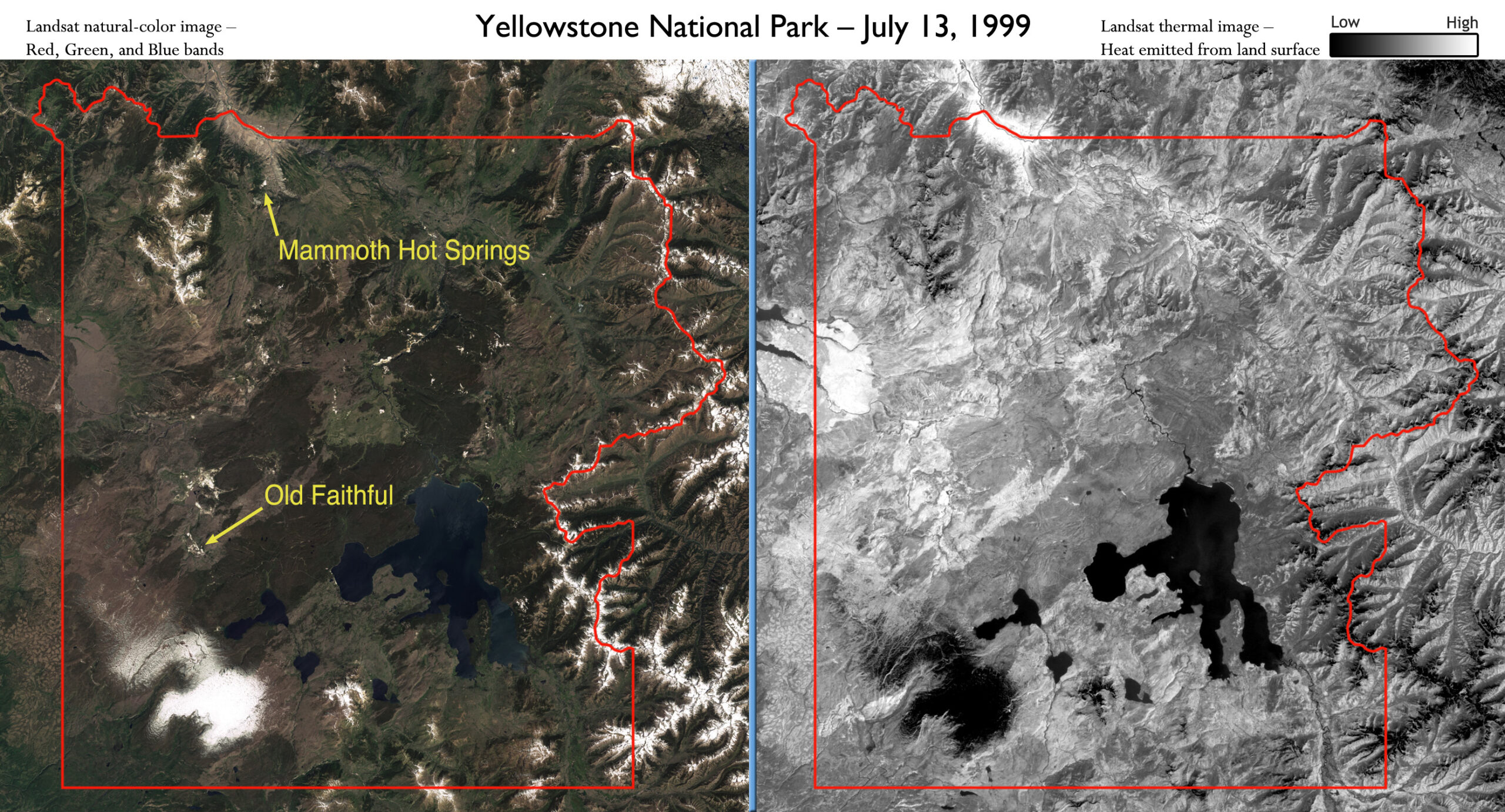
Landsat Satellites Track Yellowstone’s Underground Heat
Yellowstone National Park sits on top of a vast, ancient, and still active volcano. Heat pours off its underground magma chamber, and is the fuel for Yellowstone’s famous features—more than
Landsat Update – Volume 5 Issue 3 2011
The USGS Landsat Update is now available. Articles include: Landsat Images on Display at the Library of Congress Landsat Document Donation Wind, Fire, and Water Landsat Technical Working Group Meeting Held Upcoming
Landsat-Based Maps Aid German Relief Work in East Africa
Eastern Africa is in the grip of the worst drought it has seen in 60 years and the region is facing severe famine. In Somalia alone, it is estimated that
Landsat Satellites Track Continued Missouri River Flooding
Flooding along the Missouri River continues as shown in recent Landsat satellite images of the Nebraska and Iowa border. Heavy rains and snowmelt have caused the river to remain above
Monitoring Waterbird Habitat
In an article published this month in The International Journal of Avian Science,Spanish researchers used Landsat data to map waterbird habitat in rice paddies adjacent to the Doñana National Park in
News Archives
Understanding Disaster Aftermath in Japan
Contributors: Laura Rocchio and Julia Barsi After the violent March 11 Tohoku earthquake and devastating Japanese tsunami, the U.S. Geological Survey (USGS) coordinated a volunteer GIS-based analysis effort as part
Global Land Survey 2010 Processing Begins
Source: Jan Nelson, USGS In the past, the USGS and NASA collaborated on the creation of four global land datasets using Landsat images: one from the 1970s and one each
MSS orders held until April 1st
Source: USGS Landsat Mission Starting on Friday, March 25th, MSS orders will be held so that radiometric enhancements can be implemented. MSS processing will recommence on April 1st, and notices will
Within Reach: Easily Turning Landsat Data into Information
Source: South Dakota State University via Newswise Far-sighted data policy and cloud computing are leading to the “democratization of satellite mapping,” one expert says—and the payoff will be wider access
EarthSky Interview with Robert Bindschadler: First ever image mosaic of entire Antarctica detail
Scientists have created a mosaic of digital images collected from space showing the frozen continent of Antarctica—one of the most remote and least known places on Earth—in amazing detail for
Thirst for Knowledge: NASA Eyes World's Water
As the world moves toward adding a few more billion people in the coming decades, many people who keep an eye on the horizon find themselves worried about water. Drinking
Las Vegas 1972-2010
The city explodes across the desert! thumbnail: http://svs.gsfc.nasa.gov/vis/a010000/a010700/a010721/City_Center_CU_lrg_gal.png