
New Study Brings Antarctic Ice Loss Into Sharper Focus
A NASA study based on an innovative technique for crunching torrents of satellite data provides the clearest picture yet of changes in Antarctic ice flow into the ocean.
Landsat 9 Cryocooler Delivered Ahead of Schedule
Ball Aerospace delivered the TIRS-2 Flight Cryocooler for the Landsat 9 TIRS-2 instrument ahead of schedule to NASA’s Goddard Space Flight Center.
Landsat Summer 2017 Science Team Summary Available
A five-page summary of the 2017 Landsat Science Team Summer Meeting is now available.
Seeing Earth From Space Never Gets Old: Five Years of Landsat 8
Landsat 8 continues a streak of engineering and science success unmatched in spaceflight.
USGS Video: Landsat in Action—Monitoring Crop Land with Martha Anderson
Martha Anderson talks about the value of Landsat and its thermal data for understanding agricultural lands.
USGS Video: Landsat in Action—Minnesota Lakes with Leif Olmanson
Leif Olmanson talks about the value of Landsat data for monitoring the thousands of lakes in Minnesota.
UNESCO Launches a Pioneering Tool to Monitor Water Quality
Using data from Landsat and Sentinel-2, UNESCO is providing freshwater quality information at the global scale.
Measuring the Wide World of Rivers
Using Landsat to measure river widths around the world.
USGS Video: Landsat in Action—Changing Forest Phenology with Andrew Elmore
Elmore delves into the changing phenology of forests and how that impacts the amount of carbon dioxide going into the atmosphere.
Calculating Carbon: Tidal Marsh Contributions
Modeling the aboveground biomass and carbon of tidal marshes across the U.S.
Floating Forests: Citizen Scientists are Mapping Giant Kelp with Landsat
Learn more about the huge citizen science kelp mapping endeavor called Floating Forests.
What Lies Beneath: Mapping Benthic Habitats with Landsat
A method for mapping coral reefs or other benthic habitats over time.
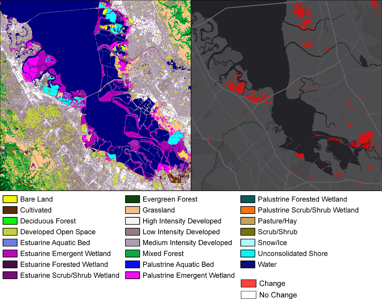
How Much Swamp Are We Talking Here? Towards Better Mapping of Coastal Wetlands
Ways to better estimate the greenhouse gas contributions of wetlands.
Graphing a Path to Survival: Habitat Connectivity in Australia's Murray-Darling Basin
Quantifying the impact of historic land-use and hydroclimatic variability on landscape connectivity dynamics across Australia’s breadbasket.
How Scientists Watched the Larsen C Ice Shelf Give Birth to an Iceberg in the Polar Night
Using Landsat 8’s thermal data to monitor calving events in Antarctica.
How Do Coastal Marshes Respond to Climate Change?
Using Landsat data from 1984-2014 to investigate the blue carbon change in Louisiana’s coastal marshes.
Measuring the Wide World of Rivers
Using Landsat to measure river widths around the world.
USGS Video: Landsat in Action—Changing Forest Phenology with Andrew Elmore
Elmore delves into the changing phenology of forests and how that impacts the amount of carbon dioxide going into the atmosphere.
Calculating Carbon: Tidal Marsh Contributions
Modeling the aboveground biomass and carbon of tidal marshes across the U.S.
Floating Forests: Citizen Scientists are Mapping Giant Kelp with Landsat
Learn more about the huge citizen science kelp mapping endeavor called Floating Forests.
What Lies Beneath: Mapping Benthic Habitats with Landsat
A method for mapping coral reefs or other benthic habitats over time.
How Much Swamp Are We Talking Here? Towards Better Mapping of Coastal Wetlands
Ways to better estimate the greenhouse gas contributions of wetlands.
Graphing a Path to Survival: Habitat Connectivity in Australia's Murray-Darling Basin
Quantifying the impact of historic land-use and hydroclimatic variability on landscape connectivity dynamics across Australia’s breadbasket.
How Scientists Watched the Larsen C Ice Shelf Give Birth to an Iceberg in the Polar Night
Using Landsat 8’s thermal data to monitor calving events in Antarctica.
How Do Coastal Marshes Respond to Climate Change?
Using Landsat data from 1984-2014 to investigate the blue carbon change in Louisiana’s coastal marshes.
