
Wind, Warm Water Revved Up Melting Antarctic Glaciers
A NASA study has located the Antarctic glaciers that accelerated the fastest between 2008 and 2014 and finds that the most likely cause of their speedup is an observed influx of warm water into the bay where they’re located.
Landsat 9 Preliminary Design Review Successfully Completed
The mission team demonstrated to an independent Standing Review Board that all design plans for the Landsat 9 mission are both sound and well integrated.
Hurricane Irma Turns Caribbean Islands Brown
Irma battered several Caribbean islands in September 2017; when the clouds cleared the destruction became obvious even from space.
Upcoming Landsat 9 Preliminary Design Review
The Landsat 9 Preliminary Design Review (PDR) is scheduled for September 12-14, 2017.
Latest Harmonized Landsat Sentinel-2 (HLS) Version Released
When Landsat 8 and Sentinel-2 data are used together observations can be more timely and accurate.
Finding Baltimore's Mosquito Hotspots with Help from Landsat
High levels of residential abandonment and unchecked vegetation growth in low-income neighborhoods are strong indicators of mosquito prevalence. Higher income neighborhoods are also susceptible to mosquito-borne disease due to the presence of irrigated vegetation, which creates mosquito-friendly habitat.
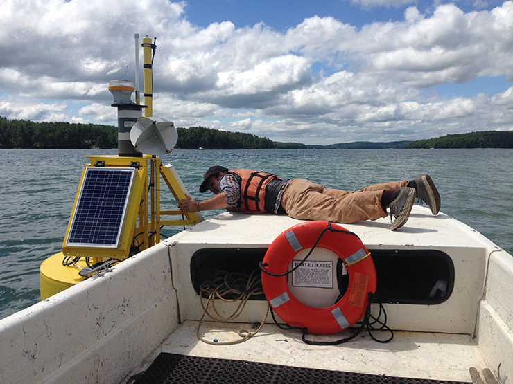
Oyster Prospecting with Landsat 8
In the first study of its kind, researchers from the University of Maine have demonstrated that Landsat 8 satellite data can be used to find locations where oysters farms should thrive.
On Iceberg Watch with Landsat's Night-Vision
NASA Goddard research scientist Chris Shuman spoke recently to National Geographic about Delaware-sized iceberg that broke away from the Larsen C ice shelf last month.
Be Part of the Next Landsat Science Team
The USGS, in cooperation with NASA, is requesting proposals for membership on the 2018-2023 Landsat Science Team.
People & Projects Shaping the Future of Land Imaging: Introducing S.J. Ben Yoo
To learn how current investments could impact the future of Landsat we are conducting a series of interviews with ESTO-funded researchers working on technology for the Landsat 10 era and beyond.
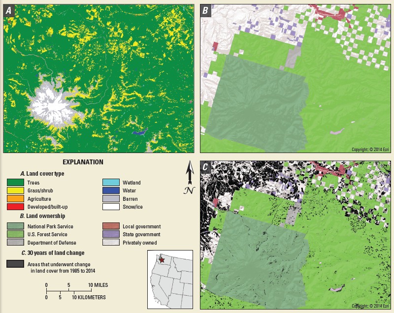
Mt. St. Helens, 37 Years of Recovery
In the decades since the Mount St. Helens eruption, scientists have studied the recovery of the ecosystem around the mountain using the Landsat series of satellites.
Myanmar’s Extensive Forests Are Declining Rapidly
The loss of intact forest cover in Myanmar has accelerated in the past decade, according to a study by Smithsonian Conservation Biology Institute scientists and partners.
"Listening to Landscapes" Wins Science's People Choice Award for 2017 Data Stories Contest
The data animation based on LandTrendr-derived land cover change illustrates the effects of political boundaries on forest cover as well as the relationship between insect infestations and forest fire behavior.
How Landsat Data Led to a Breakthrough for Lake Erie Toxic Algal Blooms
With the growing frequency and magnitude of toxic freshwater algal blooms becoming an increasingly worrisome public health concern, Carnegie scientists Jeff Ho and Anna Michalak, along with colleagues, have made new advances in understanding the drivers behind Lake Erie blooms and their implications for lake restoration.
Revolutionizing Land Cover and Land Change Research
A new initiative called Land Change Monitoring, Assessment, and Projection provides definitive, timely information on how, why, and where the planet is changing.
Landsat Images Provided to the Disaster Charter, Apr. 2017
This month, 20 Landsat scenes were ingested by the USGS Hazard Data Distribution System to provide data for Charter activations.
Landsat365
Each day of 2017, a project called Landsat365 is sharing a stunning Landsat 8 image with the public.
Be Part of the Next Landsat Science Team
The USGS, in cooperation with NASA, is requesting proposals for membership on the 2018-2023 Landsat Science Team.
People & Projects Shaping the Future of Land Imaging: Introducing S.J. Ben Yoo
To learn how current investments could impact the future of Landsat we are conducting a series of interviews with ESTO-funded researchers working on technology for the Landsat 10 era and beyond.
Mt. St. Helens, 37 Years of Recovery
In the decades since the Mount St. Helens eruption, scientists have studied the recovery of the ecosystem around the mountain using the Landsat series of satellites.
Myanmar’s Extensive Forests Are Declining Rapidly
The loss of intact forest cover in Myanmar has accelerated in the past decade, according to a study by Smithsonian Conservation Biology Institute scientists and partners.
"Listening to Landscapes" Wins Science's People Choice Award for 2017 Data Stories Contest
The data animation based on LandTrendr-derived land cover change illustrates the effects of political boundaries on forest cover as well as the relationship between insect infestations and forest fire behavior.
How Landsat Data Led to a Breakthrough for Lake Erie Toxic Algal Blooms
With the growing frequency and magnitude of toxic freshwater algal blooms becoming an increasingly worrisome public health concern, Carnegie scientists Jeff Ho and Anna Michalak, along with colleagues, have made new advances in understanding the drivers behind Lake Erie blooms and their implications for lake restoration.
Revolutionizing Land Cover and Land Change Research
A new initiative called Land Change Monitoring, Assessment, and Projection provides definitive, timely information on how, why, and where the planet is changing.
Landsat Images Provided to the Disaster Charter, Apr. 2017
This month, 20 Landsat scenes were ingested by the USGS Hazard Data Distribution System to provide data for Charter activations.
Landsat365
Each day of 2017, a project called Landsat365 is sharing a stunning Landsat 8 image with the public.
